Walk #943: A linear walk from Godmanchester to Yelling and Houghton
 |
 |
|
General Data
| Date Walked | 23/01/2012 |
| County | Cambridgeshire |
| Start Location | Godmanchester |
| End Location | Godmanchester |
| Start time | 08.09 |
| End time | 14.49 |
| Distance | 18.6 miles |
| Description | This walk follows the Pathfinder Long Distance Route south from Godmanchester across high ground to Graveley and Yelling, before returning via the same route to Godmanchester. After this I followed the trail northeastwards across the Great Ouse to Houghton, before returning along the Ouse Valley Way to Godmanchester. |
| Pack | Today I carried my 30-litre Karrimor rucksack, filled with water, my waterproofs, a book and other odds and ends. |
| Condition | I feel very tired after this walk and my feet ache a fair bit, although nowhere near as badly as they did after the last walk. |
| Weather | Today's weather was a mixture of sunshine and cloud, with sunny periods interspersed with cloud. There was quite a chilly breeze that was bothersome when fully exposed to it. |
| OS map | Landranger number 153 (Bedford & Huntingdon, St Neots & Biggleswade) |
 |
 |
|
Map of the walk
Maps courtesy of Google Maps. Route for indicative purposes only, and may have been plotted after the walk. Please let me have comments on what you think of this new format. For a detailed table of timings for this walk, please see the table file.
 |
 |
|
Notes
I had some problems with my feet during my previous walk last week, perhaps due to the two-month gap from my last walk of 2011. My initial plan for 2012 is to do the Pathfinder walk in Cambridgeshire because it is very local to me and will not involve too much driving. Last week's walk saw me do a short stretch along the southern part of the circular trail, and today I set out to do part of the western edge. Public transport appeared to be problematic, so I decided to do a there-and-back walk along the trail. I finished last week's walk in the small village of Yelling, but as there did not appear to be any public parking, or even any decent side roads to park on, I decided to drive to Godmanchester and start the walk from there.
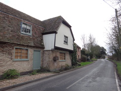
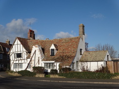
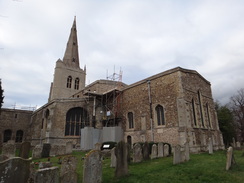
The car park in Godmanchester was free; it is also in a pleasant spot beside a weir on the Great Ouse. I was soon striding along the pavement past a series of picturesque houses and cottages that line the road, including some that are thatched. It was school time and care had to be taken to avoid a series of schoolchildren cycling at speed along the pavement; I was pleased to see that many were wearing safety helmets. It was a bit of a relief when I turned off to follow a minor road that plunged southwards, passing a man on a bike that was being pulled along by two very excitable dogs.
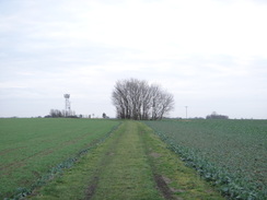
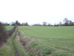
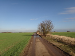
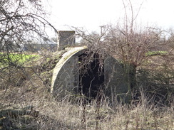
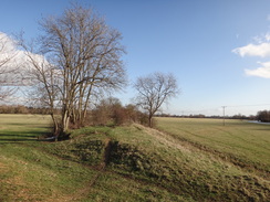
The road slowly climbed, although most of the best view lay behind me. The surfacing ended just before a farm, after which a rough track headed on between fields. There were no hedges which meant that I had no protection from the chilly breeze, but the bright skies overhead meant that it was not too miserable. It was a relief when the muddy track became better surfaced as it approached the public road opposite the old Graveley airfield; indeed a couple of concrete air-raid shelters indicates that the airfield may have extended further north than I expected from the map.
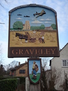
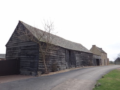
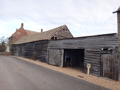
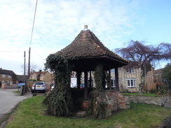
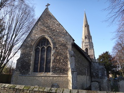
A road took me down into the village of Graveley which had some nice features, including an old pump-house that reminded me of the one in the village where my parents live. The village sign commemorates the airfield and has a solitary figure of an airman and a plaque giving information about the airfield. The road was left behind at a rather splendid farm building before a track took me southeastwards, falling and rising several times before reaching the road in Yelling. It was then a simple stroll down and uphill to reach the church where I had left the trail on the previous walk.
I turned around to start the stroll back to Godmanchester. I have an instinctive dislike of there-and-back walks which is strange as I walkways find the return walks fly by. Today proved no exception and I was surprised how quickly the walk went. Three horseriders were waiting for me on the bridleway just before Graveley and I clambered up a bank to let them past, tweaking a leg muscle in the process; this little problem would nag me for the rest of the day. When I first started long-distance walking these sort of injuries bothered me, but now I just see them as part of the hobby; something to be avoided but not concerning unless they last for several days.
The long track north towards Godmanchester was much better; the wind was slightly warmer now and the views were now ahead instead of behind me. The spire of Offord D'Arcy church was clearly visible off to the left in the Ouse Valley, and I found myself revelling in the walk, the weather and even the views. A few joggers came past, two of which had a distinct military air and one who definitely needed to wear a bra when she was out running; the latter made a guiltily pleasant sight as she bounced towards me.
Even the long walk along the road towards Godmanchester proved to be enjoyable and soon I was heading through the village, passing a small bakers and then a butchers - it was good to see independent shops flourishing in the pleasant setting. A road was closed to traffic but I sneaked past a digger and several men, none of who seemed to be doing anything other than standing around. A major road took me out of the village and under the A14(T), after which a minor one took me past a tip on the left and a sewage works on the right - hardly classic walking terrain!
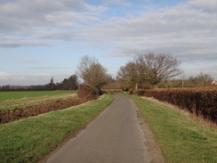
Things soon improved as a surfaced path took me eastwards across meadows, running alongside the low embankment of the old Cambridge to Huntingdon railway line. This was a splendid walk in the sunshine, with the grass seeming lusciously green against the blue sky. Sadly this stretch had to end all too soon and a road took me past what looked like very expensive houses , one of which was being built in a very curious fashion - one gable wall and the roof was complete with tiles, but the other gable end was missing - it was if they were building it from one end to the other, rather than from the bottom up.
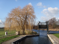
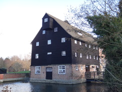
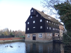
The road took me to a rather industrial-looking bridge over a river stream and to the embankment of the old railway line. Another pleasant path took me to a lock on the Great Ouse and onto the rather stunning Houghton Mill, now in the care of the National Trust. It is a fantastic building in a breathtaking location on the river. The village of Houghton itself is equally nice, with a main village square filled with interesting architectural oddities. My feet felt as though they were in need of a rest so I nipped into the Three Horseshoes pub for a while to have a pint of shandy.
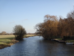
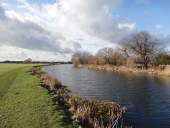
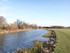
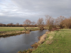
The path between Godmanchester and Houghton had not been particularly pleasant for the most part, so I decided to follow the Ouse Valley Way back rather than the Pathfinders Trail. This took me alongside the river, although sadly the earlier bright sunshine had been replaced by cloud. The breeze was also chillier and there was not much shelter on the floodplain. Despite this it was a pleasant walk and there were many boats moored on the other side of the river.
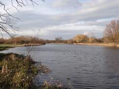
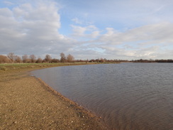
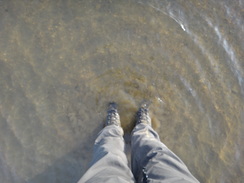
A long diversion had to be made around a tributary of the river at the Four Gate Weir, and shortly after rejoining the river the trail diverted off past a series of lakes, the remains of gravel pits. One of these had a little foreshore and I waded out a short distance to wash the mud off my boots. The path then climbed up onto the old railway embankment before passinf another lake and reach a bridge under the A14(T).
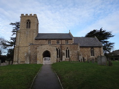
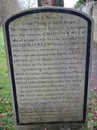
I had walked this path years ago as part of a stroll between Waterbeach and Huntingdon, and on that occasion I had seen a flight of Spitfires fly over on their way to Duxford and a cricket match progressing on the playing fields at Godmanchester. Neither of these archetypal English scenes were visible today, the cricket square being covered to protect it from the weather. It did not matter as the trail took me on towards the village church. A prominent gravestone beside the path commemorates a 21-year old woman who was murdered by her husband. It was a poignant note on which to end what had hardly been a classic walk.
 |
 |
|
Directions
This walk starts off at a free car park in the Millyard in Godmanchester, beside the river at TL244707. Leave the car park and turn right to head south along the B1044, passing close to the church which lies behind buildings on the left. Soon a mini-roundabout is reached next to the Town Hall; turn half-right to continue south along Causeway. Ignore the first road leading off to the right and take the second, Silver Street. This heads southwards past houses with a good pavement on the left; when the pavement curves to the left into a housing estate, leave it and continue straight on along the road as it slowly starts to climb to the south. 1.6 miles after the road junction in Godmanchester, the public road ends at TL246677.
A good track continues on from the end of the public road, but after a few hundred yards this curves to the left towards Debden Top Farm. Leave the track at the bend and start following a rough track south. Initially it continues to climb until it passes a mobile phone mast before starting a long and gentle descent. The surface varies in quality as it slowly falls and then climbs; just keep to the main track as it heads south. It passes Great Parlow Close Farm on the right before the track ends at a T-junction with a road at TL242647 opposite Cotton Farm and the site of the old Graveley airfield.
Turn left and follow the road as it starts to curve to the right and then left, falling to pass a road junction on the right. It starts to climb through the village, passing the Three Horseshoes pub on the left. Shortly afterwards the road curves to the left to head eastwards. Just before the road leaves the village, turn right up a bridleway that follows a track that passes the imposing stone farmhouse of Home Farm on the left.
Continue past some barns; the track soon falls and curves to the left at the bottom of a small dip. It then curves to the right and climbs in a rough southerly direction; it crests a summit before falling into a shallow valley and climbing up the other side. At the top of the climb the track becomes surfaced before it ends at a T-junction with a road in Yelling at TL258627. Turn left to follow the road as it falls downhill into a little valley; continue up the other side until Yelling Church is reached on the left at TL262624.
At the church turn around and retrace your steps back towards Godmanchester. The road heads downhill past the village hall into a little valley before climbing up the other side. As the road curves to the left near the village sign, turn right to continue straight on along Bridle End. This soon curves to the right; as it does so continue straight on along a bridleway that runs along a track. Soon the track forks; continue straight on along the main track with a hedge to the right.
The track descends northwestwards into a little valley before climbing up the other side. It becomes a sunken lane at the summit before falling once more; near the bottom it curves to the left and then the right before climbing once again. The track becomes firmer as it passes some ramshackle barns and Home Farm on the right before ending at a T-junction with a road in Graveley at TL251639.
Turn left and follow the road as it heads westwards; soon it curves to the right to head northwestwards, passing the Three Horseshoes pub on the right. The road starts to climb after passing a road junction on the left, curving to the right and then the left before levelling out beside the site of the old Graveley airfield. About 250 yards after the left-hand bend, a track comes in from the right at TL242647.
Turn right to follow a bridleway that follows the track northwards; initially it is concrete as it heads past the farm at Great Parlow Close, but soon afterwards it curves to the right and the bridleway continues straight on along a grassy path. It rises to a little summit before gently undulating; none of the slopes are in any way taxing. 1.6 miles after leaving the road a gravel track is reached near Debden Top Farm. Continue straight on down this gravel track; after a couple of hundred yards it becomes a surfaced public road.
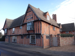
Follow this road as it slowly descends northwards; it eventually passes housing and after 1.6 miles ends at a T-junction with Old Court Hall in Godmanchester at TL245702. Turn right and follow this road as it soon curves sharply to the left, becoming London Street. As this curves to the right towards the Exhibition pub, continue straight on along Earning Street. This curves to the left and passes a series of attractive half-timbered houses; after a fifth of a mile it ends at a T-junction with the B1044 road at TL248705.
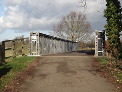
Turn right and follow the B1044 road eastwards. It soon passes under a large bridge that carries the A14(T) overhead and then starts to curve to the right, passing allotments on either side of the road. Just before the road reaches a roundabout , turn left down a dead-end road called Cow Lane. This heads northeastwards, passing between a large tip on the left and a sewage works on the right. After three-quarters of a mile the road climbs a slight slope to reach the course of the old Cambridge to Huntingdon railway line at TL263715.
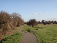
Just before the road reaches the railway line it passes a few parking spaces on the right. Immediately after these and before the slope, turn right through a bridleway gate that leads onto a surfaced path that runs eastwards across a common, with the old railway line running along a low embankment to the left. The path undulates and winds before going through a pedestrian gate beside a field gate to reach the end of a public road in Hemingford Abbots. Head straight on along the road for a third of a mile before turning left down Meadow Lane.
This leads to a metal bridge over a channel of the River Great Ouse; the bridge is somewhat inaccurately called Black Bridge. On the northern side of the bridge head across Hemingford Meadow; the path soon reaches a pedestrian gate beside a field gate. Go through this and cross the embankment of the old railway line, then continue straight on along the surfaced path as it leads to Houghton Lock at TL280719.
Go through the wooden gate and cross the bridge over the lock. Continue along the path as it winds before reaching Houghton Mill; the path crosses a small bridge and heads under the mill. On the other side pass through some wooden barriers and then turn left along a track. Soon afterwards turn right up a surfaced road that heads northwards, passing the church on the left before reaching the centre of the village of Houghton at TL281721.
The return journey to Godmanchester uses the Ouse Valley Way. Turn around and follow the road as it heads south past the church on the right; at the end of the road turn left for a few yards along a gravel track that reaches some wooden barriers on the right. Turn right past the barriers and head under Houghton Mill. On the other side cross a small bridge and follow a path that curves to the right and then the left, passing a boathouse on the left before reaching a footbridge over Houghton Lock. Cross the footbridge and go through the wooden gate on the other side.
Once through the gate, turn right and follow a path that climbs up onto the top of the flood bank. This heads westwards with the river to the right; after a third of a mile a sluice at Four Gate Pit is reached. Here the route of the Ouse Valley Way marked on the map differs from the one indicated on the ground. Go through a metal gate and cross the sluice; go through a gate at the end of the sluice and follow the path as it turns half-left to cross the floodplain. After a short distance this reaches a wooden footbridge over another channel.
Cross the bridge and on the other side turn right to follow the channel on the right. After a short distance the path curves slightly to the right to head towards a wooden footbridge. Go through a clapper gate and cross the bridge. On the other side go through another clapper gate and turn right to follow a channel on the right. Continue along the edge of the field as it curves to the left past The Rhymers Weir, after which the river is rejoined. Head westwards with the river on the right; the proper path follows the edge of the river bank with a hedge on the left; however an easier path can be found in the field behind the hedge, although this means you do not get the views across the river.
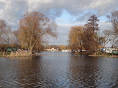
After a while the path jinks off the riverbank to go through a clapper gate before rejoining the riverbank. It passes the entrance to Hartford Marina on the other side of the river before curving to the left across a field. Cross a footbridge guarded by clapper gates and turn right along an obvious path, keeping a lake to the left. Go through a clapper gate and cross another footbridge over a ditch. Pass the end of a bridge on the right and go through a clapper gate before continuing along the path with an avenue of trees to the right.
Go through a pedestrian gate beside a field gate and continue on with Cook's Stream to the right and a lake to the left. The path curves to the left to reach another clapper gate. Continue on, still alongside the stream to reach a clapper gate. Go through this and turn right to follow the edge of the lake on the left. Follow the path as it curves to the left; at the end of the lake head straight on to reach a footbridge. Cross this and go through a field gate before turning half-left to cross a field. At the end of the field go through a hedge to reach an old railway embankment at TL253714.
Turn right to follow the embankment westwards; after a sixth of a mile turn left off the embankment and negotiate a couple of clapper gates guarding a footbridge to reach a field. Head straight on with a fence on the left; go through another clapper gate and cross a footbridge over a stream before turning half-right to follow a hedge on the right and a lake on the left. At the end of the lake the path curves to the left with the embankment carrying the A14(T) to the right. Soon the path curves to the right to head through a culvert under the A14(T).
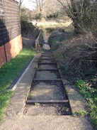
On the other side, follow the path as it curves to the right across a grassed area, with a cricket pitch to the left and then houses on the right. The path becomes surfaced as it heads on with the houses to the right. When the path ends at a T-junction with another path, turn left down another surfaced path for a few yards before turning right down a path, keeping a hedge on the right, to reach pedestrian gates. Go through these and continue on across the graveyard of Godmanchester church, following a wall to the left. The path passes the church and then turn left through a gate to reach Chadley Lane. Turn right along the lane to reach a mini-roundabout with the B1044; here turn right to head north along the road; the car park where this walk started is soon reached on the left.
 |
 |
|
Distances
| From | To | Distance (m) | Ascent (ft) | Descent (ft) |
|---|---|---|---|---|
| Godmanchester car park | Yelling church | 6.0 | 292 | 154 |
| Yelling church | Godmanchester | 6.0 | 157 | 299 |
| Godmanchester | Houghton | 2.9 | 43 | 56 |
| Houghton | Godmanchester car park | 3.7 | 30 | 13 |
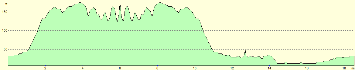
This makes a total distance of 18.6 miles, with 522 feet of ascent and 522 feet of descent.
For more information on profiles, ascents and descents, see this page
 |
 |
|
 |
 |
|
 |
 |
|
 |
 |
|
 |
 |
|
 |
 |
|
 |
 |
|
 |
 |
|
 |
 |
|
 |
 |
|
 |
 |
|
 |
 |
|
 |
 |
|
 |
 |
|
Disclaimer
Please note that I take no responsibility for anything that may happen when following these directions. If you intend to follow this route, then please use the relevant maps and check the route out before you go out. As always when walking, use common sense and you should be fine.
If you find any information on any of these routes that is inaccurate, or you wish to add anything, then please email me.
All images on this site are © of the author. Any reproduction, retransmissions, or republication of all or part of any document found on this site is expressly prohibited, unless the author has explicitly granted its prior written consent to so reproduce, retransmit, or republish the material. All other rights reserved.
Although this site includes links providing convenient direct access to other Internet sites, I do not endorse, approve, certify or make warranties or representations as to the accuracy of the information on these sites.
And finally, enjoy your walking!
Nearby walks
| # | Title | Walk length (miles) |
|---|---|---|
| 108 | Waterbeach to Huntingdon | 21.6 |
| 119 | Huntingdon to St Neots | 11.8 |
| 120 | St Neots to Biggleswade | 13.0 |
|
|

|