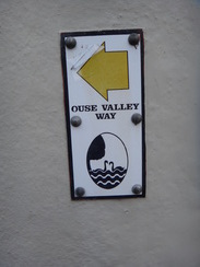
Walk #977: Ouse Valley Way: Godmanchester to Earith
 |
 |
|
General Data
| Date Walked | 08/11/2017 |
| County | Cambridgeshire |
| Start Location | Godmanchester car park |
| End Location | Earith |
| Start time | 07.48 |
| End time | 12.26 |
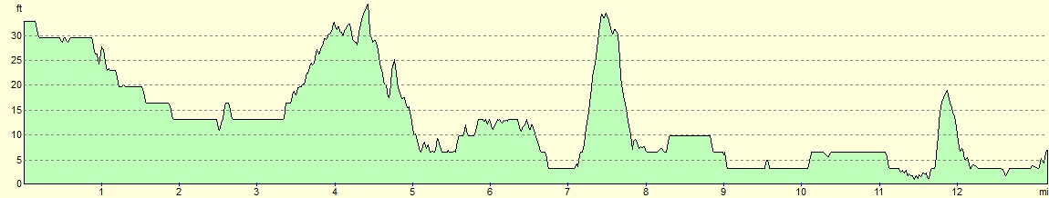
| Distance | 13.1 miles |
| Description | This was a varied walk along the Ouse Valley Way; the walk started off as a bitty and indistinct route mostly away from the river, before becoming a much more riverine stroll. |
| Pack | Today I carried my 30-litre Karrimor rucksack, filled with water, my waterproofs, a book and other odds and ends. |
| Condition | I feel absolutely fine after this walk. |
| Weather | The say started off cold and cloudy, and although there were occasional glimpses of blue sky, it drizzled late-on for well over an hour. Coupled with the stiff breeze, it made that part of the walk slightly uncomfortable. |
| OS map | Landranger number 153 (Bedford & Huntingdon, St Neots & Biggleswade), Landranger number 154 (Cambridge & Newmarket, Saffron Walden) and Landranger number 142 (Peterborough, Market Deeping & Chatteris) |
 |
 |
|
Map of the walk
Maps courtesy of Google Maps. Route for indicative purposes only, and may have been plotted after the walk. Please let me have comments on what you think of this new format. For a detailed table of timings for this walk, please see the table file.
 |
 |
|
Notes
I wanted to do another walk along the Ouse Valley Way today, so I set off early in the morning to get to Godmanchester, where I left the trail during my last walk. I know this pretty little village well, and I managed to park in a car park sited right on the trail - it's not often that happens! Opposite there is a shop and, more importantly, a bakery that make some rather tasty food. I bought a sausage roll and a BLT baguette; the former was eaten quickly whilst the latter was stuffed into my rucksack for later.
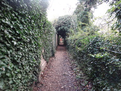
I've done the first part of this walk to St Ives several times before in both directions, and know it fairly well. It's a bit of a fiddly walk with lots of gates to negotiate as it winds past a series of lakes. It leaves Godmanchester by heading under the A14, and soon I was walking in a very different environment. It was a chilly November morning and I tried to walk a little faster, but I found I just couldn't warm up. My plans for the day were nebulous, but my initial aim was to walk to Holywell and then return following the same route. However, as I joined the embankment of the old St Ives to Huntingdon railway line, I decided I didn't want to walk this section again. I've done it twice in the last few months, and the thought of doing it again at the end of the day appalled me.
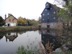
The grey skies meant that opportunities for photography were limited, and the river was often hidden from view. My mood sunk slightly and I slowed down, although I felt more positive when I finally reached Houghton Mill, a fantastic 17th-Century water mill, its brick and black-tarred woodwork is spectacular even on a grey day like today. It marked the trail's brief flirtation with Houghton, a village I like a lot. But the Ouse Valley Way took me on eastwards along roads and tarmac paths, eventually entering an area of woodland rather unimaginatively called the Thicket.
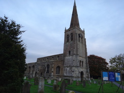
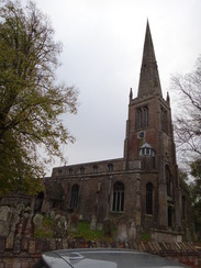
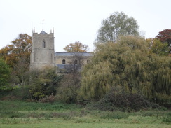
the Thicket was a pleasant walk, and I saw a rather brave black squirrel climbing a tree; only the second black squirrel I have ever seen. It was too quick for my camera, and a passing jogger stared at me, as if wondering why this idiot was so captivated by the upper branches of a tree. Soon the path took me past All Saints church in St Ives, whose spire was decapitated by a plane in March 1918. No sign of any damage is obvious, but contemporary pictures show the spire as a torn stump. At least the church was eventually restored, which is more than can be said for the plane or its unfortunate pilot.
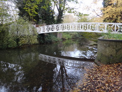
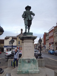
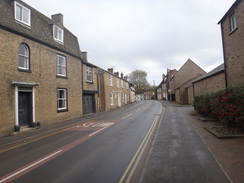
I've always liked St Ives. It's a pleasant little town, not too busy, but with enough bustle throughout the day to avoid seeming quiescent. The most famous structure in the town is perhaps its delightful bridge over the river, which has a little chapel mid-span. The town's most famous resident was Oliver Cromwell, who lived there from 1631, and whose statue stands in the market place. It seems slightly odd that both of these are celebrated in the same town, as Cromwell had two arches of the bridge pulled down during the civil war. Perhaps the bridge has won, however, as it is Grade-I listed, whilst Cromwell's statue is only Grade-II.
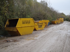
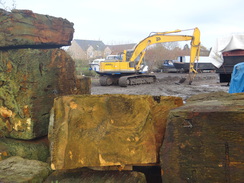
As I headed eastwards out of the town, I started to hit paths that I had never walked before. Perhaps the least pleasant stretch of path today was the arrow-straight road that headed for nearly a mile past an industrial estate, the guided bus park and ride, and finally a large complex belonging to a local plant hire and skip firm. In one place the path was nearly flooded, and lorries caused waves as they ploughed on through. I just about managed to get past with dry socks, although after heavy rain I bet it'd be a different matter. Stacks of yellow skips formed an almost artistic display near the end of the track, as if someone as hoping they would be noticed by the Tate Modern.
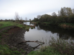
Thankfully the path left this behind and rejoined the river for a short distance, and it was perhaps the most pleasant stretch of riverside path so far today - the river burbled along gently, the sun had made a rare appearance, and I knew I was soon to reach the midpoint of the day and could start heading back. Unfortunately I was only to be in the river's company for a few hundred yards, as the map showed the trail heading away from it. There was no sign of the place the path diverted inland, but I correctly guessed that the path headed off to follow a ditch, eventually climbing to enter the small village of Holywell.
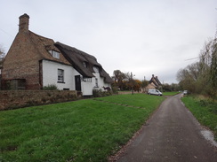
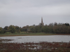
I'd never visited this village before, and it was a real treat. Everything about it is picturesque; from the thatched cottages to the green that lay between them and the road. Scatter gravel over the tarmac, put a few geese and sheep on the verges, and you might just be back in the 17th century. I ate my BLT baguette as I walked on, genuinely happy for the first time today. A tractor was cutting grass in front of the ancient Old Ferry Boat Inn, which might be the oldest inn in the country, with alcohol allegedly having been served on the site as far back as 560AD.
I was tempted to nip into the pub for a drink, especially as the village was the place I intended to turn back towards my car. However I couldn't really face doing the stretch between Godmanchester and St Ives again, and it was still relatively early in the morning. Instead I continued along the trail, which followed a path that runs along the top of a low flood bank. After a while I met two men walking in the other direction who were walking the stretch of the trail from St Earith to Huntingdon. We chatted for a few minutes before continuing our adventures. The path passed another pub, the Pike and Eel pub, but I was keen to get on and so ignored its attractions.
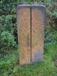
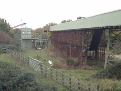
A light drizzle started to fall as I followed the flood bank, the wind blowing it in from my left. The water soaked my arm, but I couldn't be bothered to don my coat. At one point a brown metal post stuck out of the ground on the banking, an unexpected marker for the Greenwich Meridian. My mood lowered as I approached a large grey-green structure spanning the river - a conveyor belt that carries aggregate from pits away to my left. A low drone of the machines in the pit was not in the least intrusive. A lock was hidden away under the conveyor, as if it was afraid to show itself.
Here the path joined the Pathfinder Long Distance walk for a short distance, which I walked a few years ago. In fact this stretch of river has several trails along it, leading to a patchwork of waymarker blazes on each waypost. The ground became muddier after the Pathfinder route diverted inland towards Bluntisham, but at least the drizzle had decided to stop. A semi-flooded fen lay to the left of the flood bank, a culvert showing how much lower the land on that side was from the river on the right.
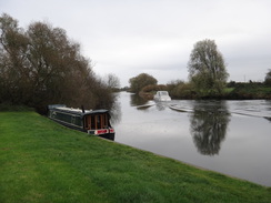
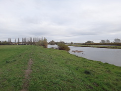
Eventually the path descended onto a lower flood bank beside some low brick abutments that lay on islands in the river, the remains of the old railway line from St Ives. The path became open on either side, with some good views over the river, but soon a marina was reached and I headed inland to reach Earith. A bus was due in an hour, and the one after was due three hours after that. Instead of hanging around (and trying to avoid the pub), I walked on along the trail. Every lamppost seemed to have a waymarking blaze when the route simply followed the road; there are certainly places on the trail that deserve them more!
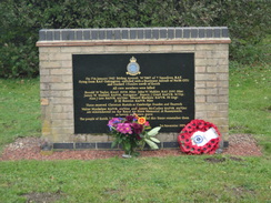
I soon reached a bridge over the start of the Old Bedford River, a long canal dug to help drain the Fens. I passed a memorial stone to a Lancaster bomber that crashed nearby in the war and started along the busy road, before realising that a seemingly newly-built path ran alongside the road. I headed down to this and followed it across the washes to a bridge over the New Bedford River. The washes are an area of land that can flood after heavy rain, and gates at either end can be closed to stop traffic. I had hoped to use a car park marked on the map for my next walk, but it seemed rather dismal, a black patch on the grass showing where a car had recently been set alight. Having decided not to use it, I headed back into Earith, arriving at what I hoped was the bus stop with half an hour to spare.
Two busses took me to Huntingdon via St Ives for 7 pounds, after which I walked a mile back to my car in Godmanchester. It had been a walk of two halves; the first half familiar and sadly boring, whilst the second was much more pleasant and enjoyable. I now need to decide what to do next: do I walk east from Earith towards Ely, joining a section of the route to King's Lynn that I have done many times before, or do I do the Bedford to St Neots stretch? I daresay I might make up my mind when I get into my car to drive to the start ...
 |
 |
|
Directions
This walk starts off at a car park in Godmanchester at TL243707. Leave the car park to reach the B1043 road. Carefully cross the road (there is a pedestrian crossing a short distance away), and then turn right for a few metres to reach a road called Church Place that passes between cream-coloured buildings. This curves to the right to reach some gates leading into the churchyard. Turn left to go through the gates, and follow a path that passes the church on the right. Go through some gates leading out of the churchyard, and then turn left along a path with a hedge on the left for a few metres. When this meets a cyclepath, turn left to follow it alongside a hedge on the left.
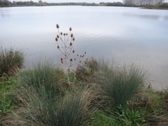
When the cycle path curves to the left after ten metres, turn right to follow a hedge on the left, cutting across grass to pass a cricket pitch to the right. Aim for a willow tree ahead; pass through a gap between it and some bushes on the right and continue on towards a bridge under the A14. On the other side of the bridge, join a track that turns to the left to parallel the A14, with a lake on the right. The track soon curves to the right to follow the lakeside. Shortly after the lake ends, continue on for a few metres to reach a footbridge over a ditch, and then go through a clapper gate to reach a field.
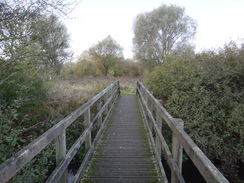
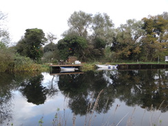
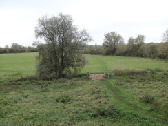
Head across the field, keeping a hedge and fence on the right. When the field ends, cross a footbridge guarded by clapper gates and climb a small bank to reach the top of an old railway line embankment at TL250714. Turn right to follow the old line eastwards. After a fifth of a mile turn left off the embankment to enter a field. Head straight on north across the field, aiming for a clapper gate in a hedge ahead. Go through the clapper gate and cross a footbridge over a ditch to reach a gap in the hedge that leads into a nature reserve, with a lake nearby. Turn left and follow the path as it runs between the lake on the right and a broad waterway called Cook's Backwater on the left.
The path curves to the right, still with a lake on the right. At TL257718 two gates are reached, one ahead and one on the left. Take the one on the left that leads through a fence, and follow a path across a small patch of land. Ignore a ramshackle bridge on the left and continue on to reach another clapper gate. Go through this and turn left to join a path that parallels a lake on the right. The path follows the lakeside as it curves to the right, still with Cook's Backwater away to the left. Eventually a clapper gate is reached beside a blocked-off metal footbridge over the backwater to the left.
Cross a little track leading to the bridge and head on through a small wooded area to reach another footbridge and clapper gate. The path parallels the backwater for a short distance, before curving to the right, roughly following a fence away to the right. The path soon curves to the left to reach a larger footbridge over a ditch, each end of which is guarded by gates. Cross this and turn half-right to follow the path, aiming for some trees in the far corner of the field, where it meets the River Ouse at TL265723.
At the trees the path curves right and goes through a broad gap in a hedge to follow the river, which mostly remains out of sight behind a hedge on the left. At the end of the field the path squeezes through another gap in a hedge with a clapper gate to enter a second field. After a little under half a mile beside the river and before the end of the field is reached, the path turns abruptly to the right to head across the field towards a stream that is crossed by a footbridge guarded by gates. On the other side, head straight on to join a tributary of the river on the left. Follow this tributary for a couple of hundred metres until a broad farm bridge is reached on the left at TL273718.
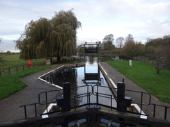
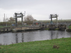
Go through a clapper gate to enter a field on the other side of the tributary, and then continue straight on across the field to reach a weir. Go through a gate and cross the footbridge over the weir; a gate on the other side leads to another path that soon rejoins the southern bank of the river. Continue along this path with the river on the left for six hundred metres until it meets a surfaced path coming in from the right, with Houghton Lock on the left. Turn left to join the path for a couple of metres until it reaches a metal pedestrian gate. Go through this to reach a footbridge over Houghton Lock at TL281719.
Continue along the path as it winds around the lock complex, soon reaching Houghton Mill. The path passes under the mill; head straight on and past a low wooden barrier. Go through the gap and turn right to enter the mill's car park, with some public toilets and a tearoom away to the right. Head straight on along a gravel path, with a caravan park to the right. Go through a gap in another low fence and head on along a tarmac path that leads to a wooden clapper gate. Go through this and turn right to join a surfaced path that follows a wall and then fence on the left.. When the path meets a track, turn left down this track for a few metres and then right to head eastwards down a road called Thicket Road.
After a fifth of a mile the road curves to the left and right to cross a ditch on a narrow bridge at TL288719; continue along the road as it continues eastwards. It becomes narrower and enters an area of woodland; after a little over a mile it meets another road at TL307717, with a scout hut off to the right. Turn half-right and continue along the path for another three hundred metres until it reaches the end of a road in front of All Saints' church, with a rather lovely white footbridge over the river on the right.
Turn left up the road for a few metres, and then immediately right through a gate to enter the churchyard. Follow a path through the churchyard, with the church on the right. Leave the churchyard through a gagte to enter a narrow lane, and follow this for about ten metres until it emerges out onto a road called The Waits in St Ives, with the river to the right. Follow this road as it heads through the town; after a little under half a mile the bus station is reached on the left. Turn left up Market Road, which becomes Cromwell Place. When this ends, turn right along Meadow Lane, which soon ends at a roundabout with the A1096 at TL317712.
Carefully cross the roundabout (the road is busy) and continue straight on along the road, which is still called Meadow Lane. It passes an industrial estate on the right, then the entrance to park and ride, and finally a large industrial area as it becomes much rougher and muddier. A mile after the roundabout the road, now little more than a track, ends at TL330704.
Turn right to follow the track southwards; when it curves to the left to a field gate after a short distance, carry straight on along a path that soon curves to the left to meet the northern riverbank. At the end of the first field, go through a clapper gate and head on across a second field. When a small ditch is reached in this second field turn left across the field, keeping the ditch on the right, aiming for the tower of Holywell church ahead; do not continue following the river. At the end of this field go through a gap in a hedge and continue on, still with the ditch on the right. The path soon reaches a clapper gate in the hedge on the right; go through this and cross a footbridge over the ditch, and then turn left to head across a field towards the church. The path crosses a farm bridge over the Marley Gap Brook and then climbs a bank to reach a clapper gate that leads to a road in Holywell at TL336707.
Turn right to follow the road as it heads through the village. After about 600 metres a road leads off to the left; continue straight on to pass the ancient Old Ferry Boat Inn on the left. Pass the pub and take a path that leads through a narrow band of trees before climbing onto a floodbank on the left. Continue along the top of this floodbank for a little over a mile until it suddenly ends at a road leading down from Needingworth to the Pike and Eel Inn at TL358713.
Cross the road and continue straight on along the low floodbank. It passes the Pike and Eel Inn, and then goes through a couple of gates to leave the inn's grounds, before joining the riverbank. After another mile a long conveyor belt spans the path and river, below which is Brownshill Lock. Continue north along the flood bank with the river to the right. Pass a little green pumping station and go through a gate and continue on. A short distance further on, ignore a path heading off inland to the left and turn right to continue along the flood bank. 1.3 miles after the lock, the path descends down from the bank to reach a clapper gate near the remains of an old rail bridge and continues alongside the river for another few hundred metres. When a fence is reached in front of a marina, turn left to follow the path away from the river, keeping a fence and then a hedge on the right. At the end of a field go through a clapper gate and up a short lane to reach the A1123 road in Earith at TL38087480.
Follow the A1123 eastwards through the village for half a mile until a bridge over the Old Bedford River is reached. Cross the bridge and pass a memorial to a bomber that crashed in the war. Shortly after this a clappergate on the left leads to a path that runs alongside the road - a much safer alternative to walking along the road. After a fifth of a mile another clapper gate leads out to a small car park beside the bridge over the New Bedford River. Here I turned back to walk back to Earith and the bus stop, which is at the junction with the B1050 Chapel Lane on the right at TL384748.
 |
 |
|
Distances
| From | To | Distance (m) | Ascent (ft) | Descent (ft) |
|---|---|---|---|---|
| Godmanchester car park | Houghton mill | 3.2 | 43 | 50 |
| Houghton Mill | St Ives bus station | 2.4 | 25 | 26 |
| St Ives bus station | Earith bus stop | 6.3 | 50 | 55 |
| Earith bus stop | Earith bus stop | 1.2 | 16 | 16 |
This makes a total distance of 13.1 miles, with 134 feet of ascent and 147 feet of descent.
For more information on profiles, ascents and descents, see this page
Transport
Five bus services a day run from Earith back to St Ives on route 21, operated by Dews coaches. Busses regularly travel from St Ives bus station to Huntingdon, from where it is a mile's walk back to Godmanchester.
 |
 |
|
 |
 |
|
 |
 |
|
 |
 |
|
 |
 |
|
 |
 |
|
 |
 |
|
 |
 |
|
 |
 |
|
 |
Disclaimer
Please note that I take no responsibility for anything that may happen when following these directions. If you intend to follow this route, then please use the relevant maps and check the route out before you go out. As always when walking, use common sense and you should be fine.
If you find any information on any of these routes that is inaccurate, or you wish to add anything, then please email me.
All images on this site are © of the author. Any reproduction, retransmissions, or republication of all or part of any document found on this site is expressly prohibited, unless the author has explicitly granted its prior written consent to so reproduce, retransmit, or republish the material. All other rights reserved.
Although this site includes links providing convenient direct access to other Internet sites, I do not endorse, approve, certify or make warranties or representations as to the accuracy of the information on these sites.
And finally, enjoy your walking!
Nearby walks
| # | Title | Walk length (miles) |
|---|---|---|
| 108 | Waterbeach to Huntingdon | 21.6 |
| 119 | Huntingdon to St Neots | 11.8 |
| 142 | Huntingdon Station to Hargrave | 17.3 |
|
|

|