Walk #976: Ouse Valley Way: St Neots to Godmanchester
 |
 |
|
General Data
| Date Walked | 03/11/2017 |
| County | Cambridgeshire |
| Start Location | St Neots Market Place |
| End Location | Huntingdon railway station |
| Start time | 09.54 |
| End time | 13.58 |
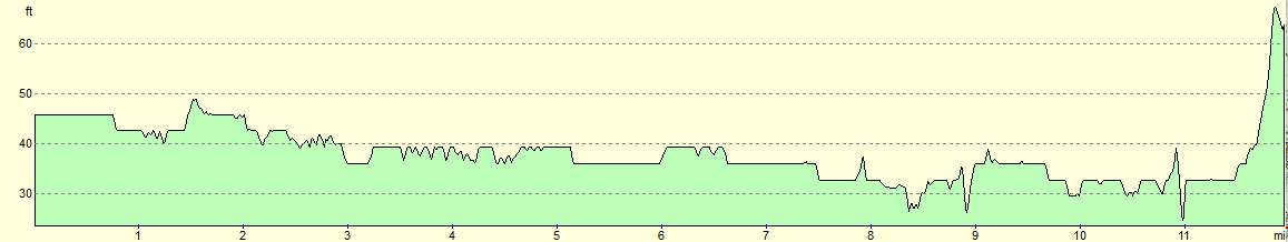
| Distance | 12.3 miles |
| Description | This pleasant walk follows the Ouse Valley Way as it heads north from St Neots to Huntingdon, spending most of the time in the company of the river. |
| Pack | Today I carried my 30-litre Karrimor rucksack, filled with water, my waterproofs, a book and other odds and ends. |
| Condition | The underside of my feet ache slightly after this walk, a symptomn of how long it has been since my last 'proper' walk. Aside fdorn this, I feel fine. |
| Weather | The day started off grey and cloudy, making some rail seem likely. Instead the clouds parted, meaning it ended up a perfect autmunal day for a riverside stroll. |
| OS map | Landranger number 153 (Bedford & Huntingdon, St Neots & Biggleswade) |
 |
 |
|
Map of the walk
Maps courtesy of Google Maps. Route for indicative purposes only, and may have been plotted after the walk. Please let me have comments on what you think of this new format. For a detailed table of timings for this walk, please see the table file.
 |
 |
|
Notes
It has been four and a half years since I logged my last walk on this website, so it may perhaps be best to explain what I've been doing. And no, I've not been in jail. A devastating death, an irksome injury, a beautiful birth, fantastic fatherhood and finally ickly illness have all conspired against my doing another 'significant' walk.
I have not been static in that period: in fact, I have been fairly active. It is just that the time required to do walks and write them up has been in short supply. Fatherhood has also meant that it has been impossible to go away on trips. Oh! If only I lived somewhere a little hillier than Cambridge!
I have a little more time now that my son has started pre-school, and my health is pretty much back to where it was. However my feet are not ready for twenty-milers just yet, and available time means that I cannot drive too far, do a walk, and get home before the end of school. After looking at my maps I decided on walking the Ouse Valley Way, which passes through my 'local' town, St Neots.
I'd walked the stretch from Huntingdon to St Neots seventeen years ago, although on that occasion I'd followed the river upstream, and my current plan is to follow it downstream. After dropping my son off at school, I drove to St Neots and parked in my usual car park (this would add a mile on after my walk, as I'd need to get back from the station to the centre of town).
St Neots is a very pleasant little town, and I visited a couple of shops and bought some food for the day before heading to the most convenient notable starting place - the market square (although the bridge over the river might have been a more sensible choice). The route north out of town skirts the site of the old Benedictine Priory (which all appears to have been built over), and passes through the car park belonging to an ugly Waitrose store which sells rather scrumptious food. Soon afterwards I got my first glimpses of the Great Ouse between buildings.
My daysack has been little-used over the last few years, and I was wearing my black Patagonia fleece that was a staple of my coastal walk. I caught a glimpse of myself in a mirror and was startled to see how scruffy I looked - evidently I've become more refined over the last few years! I've always been slightly sartorially challenged, and most of the time I care little about my appearance - which is probably a good job given how mud seems to be attracted to me.
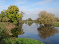
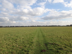
The day had started cold and overcast, but it was already warming up as I started along the grassy riverside path. Expansive gardens swept down from expensive-looking houses to the river, many fronted by private moorings. The stroll across the meadow was pleasurable, but ended too soon as the path diverted away from the river and headed towards the road leading into Little Paxton. A raised stretch of path ran alongside the road as if waiting for the next flood. Soon the river was reached once more, and a narrow path led between houses and gardens, gates in the fences on either side allowing the householders' access to their riverside land.
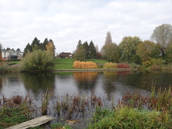
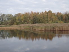
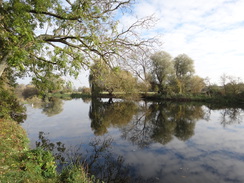
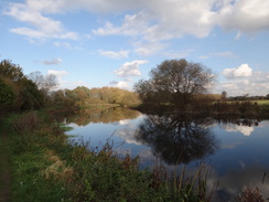
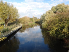
Soon the path entered the Paxton Pits Nature Reserve, a series of old gravel pits that have been flooded and made into wildlife refuges. The river and lakes were often hidden behind trees and vegetation, and the occasional glimpses I got were all the more welcome. I ignored the signs for the visitor centre and continued along the path as the clouds slowly parted and the temperature rose.
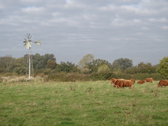
The path stuck rigidly to the riverside after leaving the reserve, and it proved to be a very pleasant stroll. Steel columns protruded high above the trees on the other side of the river, the only visual sign of the East Coast Main Line that shares the valley. The muted roars of passing trains were unintrusive, and I put my mind into neutral as I walked along. Some Highland Cows in a field provided a glimpse of Scotland.
The trail's signage was generally quite good, but I took a slight wrong turn at the approach to Buckden Marina. A clappergate led out towards a lock and I continued alongside a tributary of the river instead of heading away to a footbridge over a stream. I realised my mistake after a hundred yards (if only because the land ended with no way across the water), and I headed back to the gate and footbridge. It was one of the annoying cases where there are plenty of markers for the trail in places where the path seems obvious, and none where it is not.
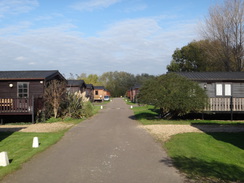
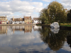
I remember being impressed with Buckden Marina when I first walked past it in 2000. It is not just a marina, but a series of waterside chalets alongside the river and a large lake. The chalets are built up on stilts, presumably to save them from floods, and every single one of them, indeed the entire marina, seemed very well-kept. It was the same this time, and even the track that wound between the chalets back to the riverbank was immaculately tidy.
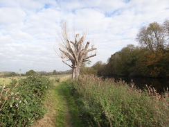
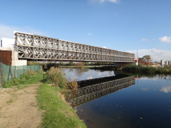
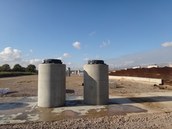
A vast metal-lattice structure spanned the river a short distance to the north, whilst the far riverbank was a hive of activity as cranes and diggers moved industriously about. The structure was a temporary bridge to allow construction traffic to cross the river as the new A14 bypass is built between Brampton and Cambridge. The bridge seemed so substantial that it's almost unthinkable that it is only temporary, and that it will be gone once the new road is open. The concrete columns that will take the new road over the river and nearby railway line stood looked more or less complete, and I can imagine the scene will appear very different in a few months, yet alone when the road opens in a few years.
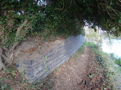
The path continued along the riverside and squeezed past a low blue-brick wall - the only remains of the bridge that had once carried the Huntingdon to Kettering railway line over the river. This line opened in 1866, but traffic was not as expected. It closed to passengers in 1959, and the line was lifted a few years later. Beeching could hardly be blamed for that particular closure!
Soon a golf course appeared on the left, and after passing a lock the path headed slightly away from the river, joining a track that headed under imposing twin bridges that carry the railway line overhead. After this the track ended and a path continued on across Port Holme meadows, the largest flood plain meadow in the UK. A path leading off to the left across the meadow offered a short cut towards Huntingdon, but instead I carried on along the trail as it cut across the meadow towards Godmanchester.
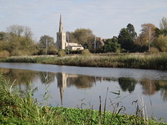
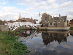
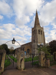
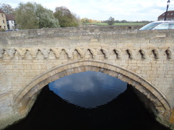
The path into Godmanchester was the highlight of the day's walk. The vista of the town's buildings above the water is always superb in good weather or foul, and proved no disappointment today. A beautiful white bridge spans the water, although the trail follows a river tributary (an old mill stream?) to reach the site of an old mill and a car park.
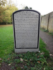
I'd planned to follow the road from Godmanchester into Huntingdon, but I was feeling fine after what had been a short walk, and wanted to go into the churchyard to see quite a remarkable object. Most tombstones are grey, austere affairs, but that of Mary Ann Weems is painted gleaming white, with black text telling the story of her sad demise in 1819. It is worth a look, even if the trail bypasses it by a few yards.
"As a warning to the young of both sexes this stone is erected by public subscription over the remains of Mary Ann Weems who at an early age became acquainted with Thomas Weems formerly of this parifh this connextion terminating in a compulfory marriage occafioned him foon to defert her and wifhing to be married to another woman he filled up the measure of his iniquity by refolving to murder his wife which he harbaroufly perpetrated at Wendy on their journey to London towards which place he had induced her to go under the mask of reconciliation May the 7th 1819 He was taken within a few hours after the crime was committed, tried and subfequently executed at Cambridge on the 7th of Auguft in the fame year Ere crime you perpetrate survey this stone learn hence the God of justice sleeps not on his throne but marks the sinner with unerring eye the suffering victim hears and makes the guilty die."
More on her sad story can be read here.
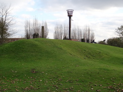
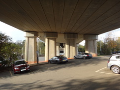
I continued out of the churchyard and followed the trail for a few yards, before heading off back to the main road through the village. I followed this under a viaduct that carries the A14 overhead - which will be removed once the new road I passed earlier opens - and into Huntingdon. As I was fresh and it was still early afternoon, I headed over the grounds of Huntingdon castle, which is now little more than a few lumps and bumps of grassy ground, with traffic bustling past on the A14. Many castles were destroyed during the civil war, but Huntingdon's had a much shorter life, being dismantled after the revolt of 1173-4. Given this, it is surprising that anything remains at all. It has survived the coming of the railway and the A14, both of which snipped away at its land, but still remains as a little oasis in the town. When the A14 closes it may once more regain some peace.
I took a little diversion to explore south of the A14, before heading back and taking a cycle path to reach Huntingdon station. I managed to buy a ticket two minutes before the train was due, and soon I was being whisked back south to St Neots. A Chinook helicopter appeared on the right of the train, heading south and travelling at roughly the same speed. I watched it for a few minutes before it slowly turned to head over us and away on the other side.
I had to walk for a mile from St Neots station back to my car in the car park; instead of following the road I took a path that is slightly more direct as it skirts schools before joining local roads. By the time I reached my car my feet were slightly sore, but it felt good to have done an 'official' walk for the first time in years. I wonder how many more I'll get to do before life once more intrudes.
 |
 |
|
Directions
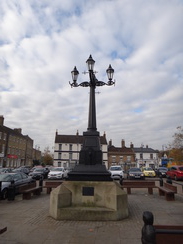
This walk starts off at the four-light decorative memorial lantern that stands in the middle of St Neots market place at TL182602. Leave the market place and head towards the road; cross the road by one of the pedestrian crossings and turn left to walk west along the road. When the Bridge House pub is reached, turn right along The Priory, and follow it as it curves to the right to head towards an ugly Waitrose store. Before the store is reached, a small car park on the left is passed; enter the exit to the car park and follow a low wooden fence on the right; when the car park ends the path squeezes between a wall on the left and the fence on the right before reaching a road called St Anselm Place at TL18196043.
Cross the road and pass some cycle barriers to continue along the path as it passes between two walls. The walls end at a cycle barrier; continue straight on up Priory Road, and when this curves to the right, head straight on along a footpath that follows a wall on the right for a few metres before passing through a hedge to reach a track. Cross the track and go through a clapper gate to enter a field; immediately turn half-left to head diagonally across the field to reach an often-muddy gateway through a hedge.
Go through the gateway into another field, and turn left to follow the edge of the field towards the river. Once the river is reached, turn right to follow the river on the left. Continue along the path for nearly half a mile; a hedge is reached shortly after a marina is passed on the other side of the river. Turn right to follow the hedge on the left to reach a gate beside a field gate. Go through this and turn half-left to follow a ditch on the right that angles towards a road ahead. The field narrows; at the tip turn right to cross a culvert over the ditch to reach a clapper gate that leads onto New Street at TL186616.
Cross the road using the pedestrian crossing and then turn left to immediately reach a crossing over another road. Cross this and continue along a tree-lined path that runs to the right of the road as it heads north for a fifth of a mile; it soon becomes a raised footbridge/causeway. It crosses two weirs over streams of the river, before passing a lock on the left to reach a wooden fence in Little Paxton at TL186619.
Turn right to follow a path that runs between fences or hedges, with the river off to the right; after about a quarter of a mile the hedge on the left ends. Continue straight on to reach a broad tarmac path with houses away to the left; just before the houses end, follow a path that angles away to the right, keeping a hedge on the right. This soon reaches a clapper gate at the entrance to Paxton Pits Nature Reserve at TL190622.
Go through the clapper gate and follow the obvious path as it follows the edge of a lake on the left; the lake ends, and soon the river becomes visible on the right. Just before the track curves away to the left at TL199625, turn right along a path that follows the river on the right. When a hedge is reached ahead, the path turns to the left away from the river, following a hedge on the rightmetres. When a metal farm gate is reached after about a hundred metres , turn right to follow an obvious path. When the path forks, turn left for about a hundred metres towards a gravel path. Turn right along this path, keeping the river off to the right. The path rejoins the riverside and finally reaches a metal clappergate leading out of the Paxton Pits Nature Reserve.
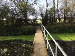
Continue along the path as it follows the river. It passes a water intake with a building on the left at TL214661. Half a mile further on, the path turns to the left to follow a tributary of the river on the right. Go through a clapper gate beside a field gate, and then immediately turn left to join a path that heads through a gap in a hedge to enter a field. Cross a section of boardwalk and follow the path as it angles towards a hedge. Go through this hedge to reach a long footbridge over a stream. Cross this, and on the other side turn right to follow a hedge on the right, with fields to the left. This path crosses a footbridge over a ditch before ending at a clapper gate that leads onto the road that joins Offord Cluny and Buckden at TL213672, with a converted mill off to the right.
Turn left to follow the road; it soon curves to the left. A few metres past the main entrance to Buckden Marina on the right, turn right through a metal clappergate in a hedge. Cross a small stretch of grass on the other side to reach a surfaced track in the marina. Follow this track as it heads north, with a lake to the left and chalets away to the right. It winds around as it passes more chalets, before ending at a turning circle beside the river.
Here turn left to follow a riverside path, following a hedge on the left. The path soon curves to the left to meet a track; immediately turn right off the track to go through a gap in the hedge and rejoin the riverside path. There are several gates and a footbridge to be negotiated; just keep the river on the right. The path eventually passes a golf course on the left, and then enters a wooded area; just under two miles after the marina, the path reaches TL223706, with Brampton Lock away to the right across the river.
The path then curves to the right before ending at a concrete path. Turn left to follow the path as it passes a pond and picnic area on the left. When a farm gate is reached, turn left along a path that curves around to the right, rejoining the path after a few metres. It then crosses a footbridge over a mill leat and curves to the right, passing a caravan site on the left. The concrete path becomes tarmac, and when a T-junction is reached turn left down a track, keeping the caravan park on the left and a little mooring area for boats on the right.
When the entrance to the caravan park is reached on the left at TL224708, turn right to follow a track called Bromholme Lane. This track soon crosses a bridge over a stream before curving to the left to head towards a railway line. It passes under two railway bridges, and the track becomes rougher as it approaches a bridge over a little stream. On the other side of the bridge, go through a clapper gate to enter some meadows. Head straight across the meadows, aiming slightly to the right of Godmanchester church's spire.
After two-thirds of a mile a clapper gate is reached at the far end of the meadows. Go through two gates and climb up to a footbridge over Godmanchester lock, and then follow a tarmac path that turns to the left to follow the river on the right. It crosses a couple of weirs before crossing the river on a third bridge. Immediately after this the path curves to the left; ignore a graceful white bridge on the right, and instead continue on following a stream on the right. This ends at a bridge over the stream; turn right to cross this to reach a car park in Godmanchester at TL243707.
Leave the car park to reach the B1043 road; this can be followed back to Huntingdon, but I extended the walk slightly. Carefully cross the B1043 (there is a pedestrian crossing a short distance away), and then turn right for a few yards to reach a track called Church Place that passes between cream-coloured buildings. This soon curves to the right to reach some gates leading into the churchyard. Turn left to go through the gates, and turn half-right to follow a path that passes to the left of the church. Go through some gates leading out of the churchyard, and turn left along a path with a hedge on the left, and then turn left to join a cycle path with a hedge on the left. Here the Ouse Valley Way is left as it heads on towards Houghton.
Instead, continue along the cycle path as it heads northwestwards; it joins Park Lane, and this is followed until it reaches the B1043. Turn right to follow the B1043 northwards; use a pedestrian crossing to reach the left-hand side of the road and continue northwards. The road passes under a large viaduct carrying the A14 overhead before curving to the left to reach the old town bridge over the Great Ouse; there is a pedestrian bridge alongside on the left.
When the roads ends at Huntingdon's ring road, turn left to follow the ring road westwards. After a few yards turn left to follow a tarmac path that heads through the castle grounds; after leaving the grounds it squeezes between fences and becomes a track called Castle Hill. This soon ends at a T-junction with a surfaced road called Mill Common. Turn right up Mill Common, passing a car park on the right, to reach the ring road.
Turn left to follow the ring road past a grassy area on the left, and once the bus station is reached across the road on the right, turn left to join a surfaced cycle path that heads across a cattle grid. Initially there are some houses on the right; these are left behind and the path continues on across some rough grassy land as it heads towards the A14. It skirts the bottom of the A14's embankment for a short distance before crossing another cattle grid to enter Huntingdon station car park. Turn left to pass under the A14 viaduct to reach the station at TL232716.
That is not the end of the directions. The train drops you off at the railway station in St Neots, whilst the walk started from the centre of the town, a mile away. To get back, use the following directions:
Leave the station and turn left, passing some railway cottages on the right. At the end of the cottages, turn right down a short path that leads out onto Hawkesden Road. Cross the road using the pedestrian crossing, and continue straight on along a cycle path. This passes some flats on the left and a school on the right; when Longsands Road is reached, cross it and continue along the path. The path curves to the left to pass Longsands Academy on the right. Just past the school, the cycle path turns to the left to reach Princes Drive.
Turn right to follow Princes Drive west for a short distance until it ends at a T-junction with King's Lane. Turn left down King's Lane, and then take the first road off to the right, Avenue Road. Follow this westwards for a quarter of a mile until it ends at the B1043 Huntingdon Street. Turn left to follow this road south for a couple of hundred metres until it meets the B1428 High Street in the centre of St Neots. Turn right to follow this westwards through the town; the market place where this walk started is on the left before the river bridge.
 |
 |
|
Distances
| From | To | Distance (m) | Ascent (ft) | Descent (ft) |
|---|---|---|---|---|
| St Neots marketplace | Buckden Marina | 6.3 | 0 | 20 |
| Buckden marina | Godmanchester car park | 4.2 | 29 | 27 |
| Godmanchester | Huntingdon railway station | 1.8 | 45 | 16 |
This makes a total distance of 12.3 miles, with 74 feet of ascent and 63 feet of descent.
For more information on profiles, ascents and descents, see this page
Transport
Regular services run between Huntingdon and St Neots stations, after which you need to walk a mile back to the centre of St Neots (as described in the directions above).
 |
 |
|
 |
 |
|
 |
 |
|
 |
 |
|
 |
 |
|
 |
 |
|
 |
 |
|
 |
 |
|
 |
 |
|
 |
 |
|
Disclaimer
Please note that I take no responsibility for anything that may happen when following these directions. If you intend to follow this route, then please use the relevant maps and check the route out before you go out. As always when walking, use common sense and you should be fine.
If you find any information on any of these routes that is inaccurate, or you wish to add anything, then please email me.
All images on this site are © of the author. Any reproduction, retransmissions, or republication of all or part of any document found on this site is expressly prohibited, unless the author has explicitly granted its prior written consent to so reproduce, retransmit, or republish the material. All other rights reserved.
Although this site includes links providing convenient direct access to other Internet sites, I do not endorse, approve, certify or make warranties or representations as to the accuracy of the information on these sites.
And finally, enjoy your walking!
Nearby walks
| # | Title | Walk length (miles) |
|---|---|---|
| 108 | Waterbeach to Huntingdon | 21.6 |
| 119 | Huntingdon to St Neots | 11.8 |
| 120 | St Neots to Biggleswade | 13.0 |
|
|

|