Walk #1011: A meandering circular walk between the Falkirk Wheel and the Kelpies
 |
 |
|
General Data
| Date Walked | 09/08/2018 |
| County | Central Scotland |
| Start Location | Falkirk Wheel |
| End Location | Falkirk Wheel |
| Start time | 12.46 |
| End time | 17.18 |
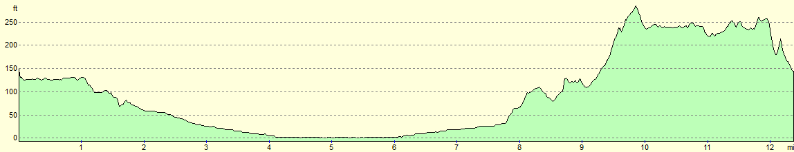
| Distance | 12.5 miles |
| Description | This was a surprisingly interesting walk, following parts of the Forth and Clyde and Union Canals, to take in the Falkirk Wheel, the Kelpies, the Helix park and the centre of Falkirk. |
| Pack | Today I carried my 30-litre Karrimor rucksack, filled with water, my spare waterproofs, a book and other odds and ends. |
| Condition | I wore normal socks today, and the underside of my feet ached slightly by the end of the walk. Aside from this, I feel fine. |
| Weather | Today was bright and sunny, with a little breeze. It was not too warm, and once or twice I even considered putting my fleece on. |
| OS map | Landranger number 65 (Falkirk & Linlithgow, Dunfermline) |
 |
 |
|
Map of the walk
Maps courtesy of Google Maps. Route for indicative purposes only, and may have been plotted after the walk. Please let me have comments on what you think of this new format. For a detailed table of timings for this walk, please see the table file.
 |
 |
|
Notes
Sencan has taken Robert to Turkey for a week, and so I decided to take my own little trip. The seven days available didn't leave me enough time to do any of the named trails on my list, so I decided to head up to Scotland to do a walk I'd been meaning to do since my coastal walk: to walk the canal between Edinburgh and Glasgow, and hence connect up the east and west coasts. I set off at ten to six this morning, and after a reasonable drive I arrived in Falkirk just before one. I had wanted to stay in Edinburgh, but unfortunately the Edinburgh Fringe had made the few available rooms very expensive. Instead, Falkirk seemed a reasonably central place to use as a base.
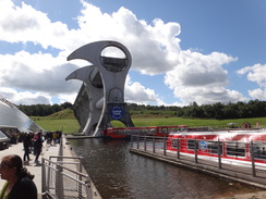
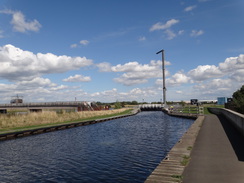
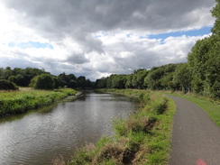
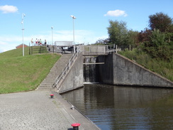
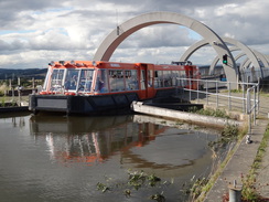
The sun was shining when I arrived, and as it was far too early to go to the hotel, I decided to do the short stretch of canal between the Falkirk Wheel and Grangemouth, which would connect this trip up with my coastal walk. The Falkirk Wheel was just as impressive as when I last saw it fifteen years ago, and I watched as it slowly revolved to deposit a boat in the lower pond. After having a quick look around the visitor's centre, I crossed a swing bridge over the canal and started heading down the Forth and Clyde Canal towards the River Carron.
Scotland's Central Belt has two main canals: the Forth and Clyde Canal spans the country from Grangrmouth on the Forth to Bowling on the Clyde, and is the major canal. However the capital city of Edinburgh lies further west, so the Union Canal stretches from Edinburgh east to Falkirk, where it meets the longer canal. The canals fell into disuse in the mid twentieth century, but were reopened over a number of years to the Millennium, a process that in places required major works such as the Falkirk Wheel.
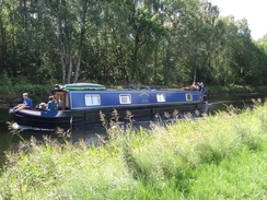
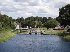
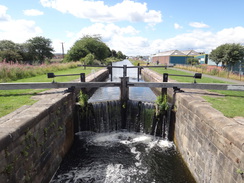
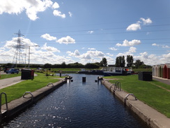
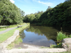
A canal boat passed me as I followed the canal eastwards, but it soon disappeared into the first of many locks that take the canal down to the sea. A pub marked the place where the Union Canal from Edinburgh used to join the Forth and Clyde by a series of locks; these were destroyed after the canal was closed, and the junction was moved further west when the link was rebuilt at the Millennium. A flight of locks led down, and there were signs that this canal had also been redesigned, if not as dramatically: a narrowing of the canal between stone walls marked an old, disused lock, a new lock having been built 'upstream' to lower the water to provide headroom under a new bridge.
A railway line blocked the towpath, so a long flight of steps led up to a road bridge, on the other side of which more steps led back down to the towpath. The canal led on, and a long (and sadly fairly boring) stretch ran alongside a road, on the other side of which was an industrial estate. It was not the most pleasant plod, but eventually the road was left behind and the canal carried on – at least it did on the ground, but my now-dated 1:50,000 map showed it ending, whocinghow much this area has changed over the last twenty years.
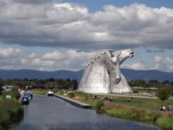
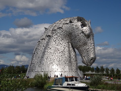
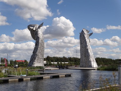
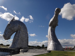
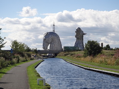
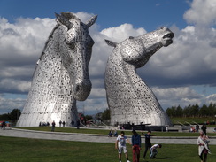
Suddenly, through the hedge on my left, I got a glimpse of two gleaming metallic horses' heads. These are the Kelpies, two thirty-metre high horse sculptures, and the largest equine sculptures in the world. I had vaguely known about them when they were built five years ago, and I had been rather dismissive of them. The canal turned, and my solitary walk became invaded by hordes of people taking photos of the sculptures. And who can blame them, for the Kelpies are breathtaking, both in beauty and scale. I headed along the canal, past another lock, to the sea lock where the new canal joins the River Carron and then the sea.
But this was not the end for me; my main target was to connect up with my coastal walk, which annoyingly lay on the other side of the M9. My planned route was to follow roads, but Google Maps had showed an intriguing path – not marked on either of my maps – heading under the motorway. A path led past the Kelpies and a lock, where I was surprised to find another canal leading under the motorway. I followed its towpath, which is named after the Charlotte Dundas, a steamship built by William Symington in Grangemouth in 1803. This was the first steamship with enough power to do useful work, in this case to tow two seventy-ton barges to Glasgow. As such it is a ship that heralded a massive change in world trade.
On my coastal walk I had followed the A905 road across the river Carron, and was intrigued that the canal appeared to carry on beyond it. A sign stated that this canal was an extension that had only opened the previous year, which perhaps explained the crystal clear water within it. Further research shows that it was built because the new sea lock I had passed at the Kelpies was not very good operationally, with the motorway bridge and a low pipe bridge across the river downstream causing problems. The extension had been built to allow boaters a better access, and indeed it ended at a lock just downstream of the pipe bridge. It had been an unexpected and pleasant walk along the canal, and a path continued on along what had used to be a ropewalk; this ended at a nondescript local road in Grangemouth; this new stretch from the A905 might actually make a 'better' route for a coastal walk.
At the road I turned around and headed back to the Kelpies, which were surrounded by people in the sunshine – and who could blame them on what was a fairly warm day. The Kelpies are just part of a larger park called 'the Helix' and it's hard to think of a more successful regeneration of an area, turning what was once bleak wasteland into one of Scotland's busiest visitor attractions. I nipped into the visitor centre for a quick look, and then walked along the canal past the locks, taking frequent glances backwards towards the Kelpies.
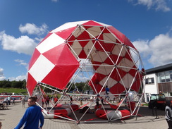
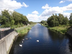
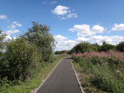
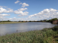
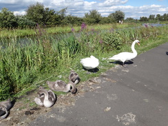
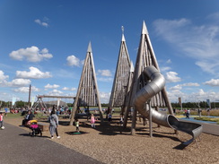
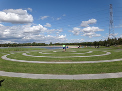
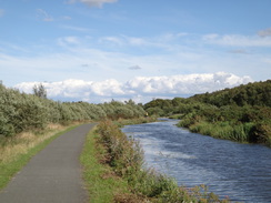
Earlier on I had noticed people walking along the other bank of the canal, and I decided to follow this past a family of swans that were nesting by the towpath. This seemed a mistake when the path soon left the canal and went deeper into the Helix. This led to a rather pleasant meandering stroll through the park, which was very well laid our and appointed. A childrens' play area had a massive climbing frame, and there was a lake with adjacent splash area – I'd love to bring Robert here.
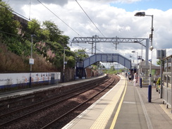
Eventually I had to leave the park, and I crossed a busy road to reach another that led into Falkirk town centre. This was very nondescript, and a bit of a let-down after the walk through the Helix. I reached Falkirk Grahamston station, and then cut through the town to climb towards the town's second station, Falkirk High. The Union canal runs immediately behind this, and I joined that canal and started following it westwards. There were some occasional glimpses of good views north over the adjacent railway line, and the path underfoot was good.
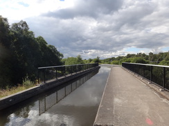
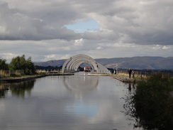
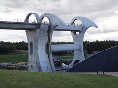
I passed the place where the Union Canal used to descend down through eleven locks to reach the Forth and Clyde canal at lock 16, which I had passed earlier. That route was unavailable when they reopened the canal, and so they built a new stretch, with the Falkirk Wheel replacing the locks. The new stretch was a pleasant enough walk, the occasional views glimpsed through the trees showing why the Romans built the Antonine Wall here. Eventually two locks were reached, which took the canal down in two large drops to head under a railway line and through a tunnel, the arched roof of which perfectly matched the steel arches of the Falkirk Wheel beyond. I walked as far along the wheel as I could, and then headed back down to the visitors centre.
This had been an unexpected half-days walk, and a very rewarding one – in fact, in places it was spectacular. It was a very good start to this trip.
 |
 |
|
Directions
Note: This walk can only be walked when the Falkirk Wheel Visitor's Centre is open, as the centre controls access to the footbridge required to cross the Forth and Clyde canal at the start of the walk. The alternative route is to folow roads to Lock Sixteen in Falkirk, where the canal can be crossed to join the towpath on the northern bank.
This walk starts off outside the Falkirk Wheel Visitor's Centre at NS85278020. From the main entrance of the visitor's centre, head north away from the wheel, passing between a lock on the left and a building on the right. At the far end of the lock, turn right along a surfaced path that passes the building on the right to reach a gate - this gate is only open when the visitor's centre is open. Go through the gate to reach a swing-footbridge over the canal at NS85318023.
Cross the bridge, and then turn right to start following the surfaced canal towpath eastwards, with the water on the right. After 1.6km lock 16 is passed, and immediately beside the lock the towpath joins a road for a short distance to reach a bridge that carries a road over the canal, with a roundabout on the left. Carefully cross the road and continue along the towpath on the other side, still with the water on the right. Pass the Canal Inn on the left, and then locks 15-11. Immediately after lock 11, follow the towpath as it angles right to head under the A803 bridge (bridge #6). Locks 10 and 9 follow in quick succession, with a low bridge carrying a rail line above the canal immediately ahead of the latter at NS87858050.
At lock 9, turn left for a few metres to a long flight of steps that leads up onto the A9. At the top, turn right along the pavement to cross a bridge over the railway line, and immediately on the other side turn right through a gap between the bridge's parapet and a crash barrier to reach some steps that lead down to the canal's towpath. Turn left to continue following the towpath, with the water on the right. This passes lock 8 and crosses a minor road. Locks 7 and 6 soon follow, after which the canal heads northeastwards to reach lock 5 at NS88758117.
When the towpath forks at lock 5, take the right-hand branch that heads down steps under a bridge that carries Grahams Road over the canal. On the other side the canal curves right to head eastwards for 1km towards lock 4, with a road on the left. Pass this, and on the other side the towpath continues on as it heads under a curving bridge that carries the A9 overhead. Shortly after this the towpath jinks around an old sluice and passes under power lines before curving left to reach lock 3. Continue on north along the towpath, still with the water to the right, and follow it past the Kelpies which sit on the other side of the water. The towpath passes some moorings and when it forks, take the right-hand branch to reach lock 2 at NS90578221, immediately in front of the River Carron.
Turn right to cross the lock gates, and on the other side turn partly right to head towards the Kelpies. Pass one of the Kelpies and a lock, to reach a footbridge over a canal branch. Cross this, and on the other side turn left to immediately reach a bridge that heads under the M9, with the canal to the left. Follow the towpath eastwards for about 350 metres until the path curves right for about twenty metres to reach the A905 road. Cross the road using the pedestrian crossing, and on the other side follow the towpath as it curves left and right to rejoin the canal. Follow this eastward for another 400 metres until it reaches another sea lock (“New River Carron Sea Lock”, number 1 on the canal) near a pipe bridge at NS91468232.
Pass the lock, and continue on along a surfaced path that roughly parallels the River Carron on the left. This passes through a wooded area and then curves right, passing a wall on the left to reach Dalgrain Road in Glensburgh at NS91848215.
From here, head back to the Kelpies. Turn around and follow the narrow path as it passes a wall on the right. The path curves left through a wooded area to parallel the river, and soon reaches a sea lock near a pipe bridge at NS91468232.
Join the canal towpath and follow it westwards back towards the Kelpies; 400 metres after the lock it curves left to reach the A905 road. Cross this using the pedestrian crossing, and on the other side follow a path that curves right and then left to rejoin the canal. Follow this westwards for another 350 metres to reach a bridge under the M9. Head under this to reach a footbridge over the canal on the right beside the Kelpies. Turn left to head past one of the Kelpies on the right and a visitors centre on the left to reach the eastern bank of the canal. Follow a path with the water on the right to reach lock 3 at NS90688177.
Do not cross the bridge at the lock, and instead keep the canal on the right. The canal soon curves right, and after a while the path curves left away from the canal to meet a road. Stay on the path as it follows the road around to the left, passing a car park on the right, and at a crossing by the car park's entrance cross the road to the left-hand side. Immediately angle right along a path that heads south, and when the path forks take the right-hand branch that gently curves right. It passes the end of a large ornamental wall. At the wall turn right along another path that gently curves left. When this forks near a cafe, take the right-hand branch that curves right towards a large childrens' play area on the left. Pass this, and on the far side, and before a road is reached, turn left along another path that passes the play area on the right. This path curves right and passes a circular lake on the left. When the path forks once more, take the right-hand branch that angles away from the lake, and at another fork take another right-hand branch that passes cycle barriers to reach the A9 beside a roundabout at NS90508065.
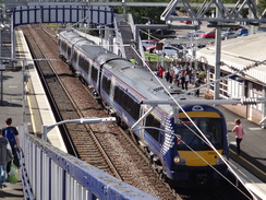
There is no pedestrian crossing over the A9, so carefully cross the busy road, and on the other side head straight on down the A904 Grangemouth Road. Follow the road westwards; after 1.2km it passes under a railway bridge and continues on into the centre of Falkirk. 500 metres after the bridge the road curves right and then left; when it forks take the right-hand fork and continue along the road as it curves left to reach a roundabout. Take the first road off to the right, which immediately crosses a railway line. Carefully cross the road on the bridge to reach Falkirk Grahamston station at NS88838024.
At the station entrance, turn left to head back towards the roundabout, but after a few metres descend some steps that leads to an underpass. Head south under a road, and on the other side follow a ramp that slopes up to join Vicar Street. Head up the road until it ends at a T-junction with the High Street; turn left along the High Street and then take the second road off to the right, Cow Wynd. When this road ends at a T-junction, angle right across the end of Rosehall Terrace and continue on for a few metres to reach a roundabout. Cross this and head on southwards uphill, crossing a second roundabout. Just before the road curves left beside a tower block, turn right down Gartcows Road and after a few metres use a pedestrian crossing to cross the road, and then head up High Station Road. This soon ends at a turning circle outside Falkirk High station at NS88297910.
Turn around and head back down High Station Road for a few metres, and then right up a little cul-de-sac. When this soon ends, take a path that leads to steps that climb up onto a bridge carrying Slamannan Road. Turn right to follow the road west uphill over the railway line. Pass an entrance to a station car park on the right, and then turn right down a steep path, initially with a wall on the right. This leads down to reach the surfaced canal towpath just to the north of a tunnel portal at NS88107909.
Turn right to follow the towpath north away from the tunnel; it immediately curves left to take a more west-northwesterlyt course. It passes the site of an old lock, which is the old top lock of the flight down to the Forth and Clyde. If the Falkirk Wheel Visitors Centre is not open, then you will need to turn right to head down towards the other canal. After 1.6km the towpath passes a little stub of the canal away to the left, and curves right to reach an aqueduct over a road. 700 metres after this, the towpath passes a vehicle barrier to reach a track. Turn left along this and follow it as it immediately curves right. When it curves left to cross a bridge over the canal, head straight on past vehicle barriers to descend a slope that rejoins the canalside. Follow the towpath westwards for another 400 metres to reach a lock at NS85397962.
Take a path that dives down past the lock and a second lock. After the second lock, the towpath curves right to head north to reach Rough Castle tunnel. Head through this, and on the other side continue on for a few metres until the path forks. Take the right-hand fork that descends down, passing a car park on the right and then curving left to descend back towards the Falkirk Wheel visitors centre at NS85278020, where this walk started and ends.
 |
 |
|
Distances
| From | To | Distance (m) | Ascent (ft) | Descent (ft) |
|---|---|---|---|---|
| Falkirk Wheel | Glensburgh | 5.2 | 17 | 145 |
| Glensburgh | Falkirk Grahamston station | 3.4 | 115 | 42 |
| Falkirk Grahamston station | Falkirk High station | 1.1 | 158 | 4 |
| Falkirk High station | Falkirk Wheel | 2.8 | 45 | 144 |
This makes a total distance of miles, with 335 feet of ascent and 335 feet of descent.
For more information on profiles, ascents and descents, see this page
Accommodation
I spent the night at the Premier Inn hotel in Larbert, near Falkirk. This was about half a mile from Larbert railway station, which has regular services to and from Edinburgh and Glasgow, granting easy access large swathes of the central belt.
Unfortunately it was rather expensive when I visited, as the Edinburgh Fringe was on in Edinburgh, and the European Championships in Glasgow, pushing up prices.
 |
 |
|
 |
 |
|
 |
 |
|
 |
 |
|
 |
 |
|
 |
 |
|
 |
 |
|
 |
 |
|
 |
 |
|
 |
 |
|
 |
Disclaimer
Please note that I take no responsibility for anything that may happen when following these directions. If you intend to follow this route, then please use the relevant maps and check the route out before you go out. As always when walking, use common sense and you should be fine.
If you find any information on any of these routes that is inaccurate, or you wish to add anything, then please email me.
All images on this site are © of the author. Any reproduction, retransmissions, or republication of all or part of any document found on this site is expressly prohibited, unless the author has explicitly granted its prior written consent to so reproduce, retransmit, or republish the material. All other rights reserved.
Although this site includes links providing convenient direct access to other Internet sites, I do not endorse, approve, certify or make warranties or representations as to the accuracy of the information on these sites.
And finally, enjoy your walking!
Nearby walks
| # | Title | Walk length (miles) |
|---|---|---|
| 564 | Aberdour to Culross | 22.0 |
| 565 | Culross to Boness | 16.8 |
| 566 | Boness to Muirhouse | 18.9 |
|
|

|