Walk #1017: Barrow-on-Trent to Melbourne via Thringstone, Whitwick and Breedon-on-the-Hill
 |
 |
|
General Data
| Date Walked | 25/08/2018 |
| County | Derbyshire, Leicestershire |
| Start Location | Barrow Upon Trent |
| End Location | Melbourne |
| Start time | 06.04 |
| End time | 13.39 |
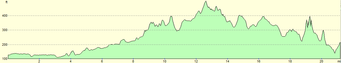
| Distance | 21.1 miles |
| Description | This was an interesting walk following roads, canal towpath and an old railway line, that explores the Derbyshire / Leicestershire border. |
| Pack | Today I carried my 30-litre Karrimor rucksack, filled with water, my spare waterproofs, a book and other odds and ends. |
| Condition | I feel absolutely fine after this walk. |
| Weather | The day started off slightly chilly, with a mixture of sunshine and clouds. It warmed up considerably as the morning progressed, although the combination of sunshine and cloud continued. There was a very heavy downpour about an hour after I finished. |
| OS map | Landranger number 128 (Derby & Burton upon Trent) and Landranger number 129 (Nottingham & Loughborough, Melton Mowbray) |
 |
 |
|
Map of the walk
Maps courtesy of Google Maps. Route for indicative purposes only, and may have been plotted after the walk. Please let me have comments on what you think of this new format. For a detailed table of timings for this walk, please see the table file.
 |
 |
|
Notes
Yesterday I attended a funeral for my uncle, Simon Heath, who died a few weeks ago. It was a sad event – funerals are rarely joyous – but there were also laughter and smiles amongst the tears. I stayed with my parents overnight, and it felt like a good opportunity to do a walk today whilst I was up in Derbyshire.
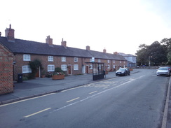
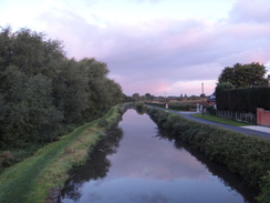
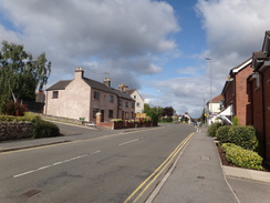
A few years back I It felt unusual to be able to get up out of bed, shoulder my rucksack, and head out of the door for a walk without having to jump into my car, but that was exactly what I did just as it started to get light. The first task was to walk through the village of Barrow-on-Trent and cross a main road – deadly quiet at this time of the morning – to reach the canal.
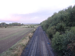
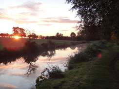
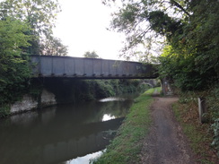
Heavy overnight rain had wet the grass on the towpath, but the skies were blue and the few clouds glowed orange as the sun rose above the horizon. A railway line paralleled the canal – the freight-only line from Stenson Junction (which is just south of Derby) to Sheet Stores Junction near Long Eaton. I had been born near this line, and as a child innumerable coal trains had clanked past on their way to various Trent Valley power stations. Today, however, several passenger trains sped past. The tracks through Derby station are closed for weeks for remodelling, and many passenger trains are being diverted via this line.
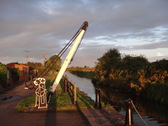
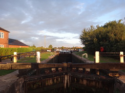
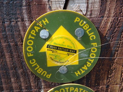
A farm sits at the top of a hill to the left, where my aunt lives, and I was in a good mood as I followed the canal eastwards, passing a lock at the junction with the Derby branch of the canal – a branch that may well be restored to navigation. I'd love to walk all ninety-odd miles of the Trent and Mersey Canal sometime, but so far I have only done a few little bits, and I'd be doing no more today, as after a few miles I diverted off to join the route of the old Derby to Ashby railway line, which now carries the Cloud Trail.
This railway line has an interesting history: it opened to Melbourne in 1868, and to Ashby-de-la-Zouch six years later, the latter section involving the reuse of part of the old Ticknall Tramway. For most of its existence it was a fairly unremarkable line, carrying a few passenger services and some freight until 1930, when passenger services were stopped. However in 1939 the army started looking for a line that they could use to train troops on, as their Longmoor Military Railway was at capacity. The Melbourne line's proximity to the railway centre at Derby saw it being taken over for this purpose, and a large army camp was built near Chellaston Junction. The line was handed back to the LMS in 1945, and continued in operation until 1982 for freight, after which the track was finally lifted in 1988. Despite its military use, it seems a curiously unregarded line, and there is little information about its post-war use on the web. It seems that the stretch north of Worthington was kept open for lime from the Cloud Hill Quarry and coal from New Lount mine.
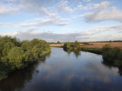
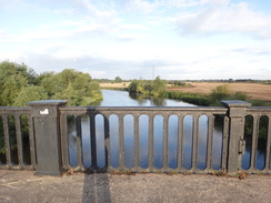
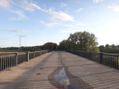
After closure, the stretch from the Castle Donnington line to Worthington was converted into a cycle path, the Cloud Trail. A few metres after joining, this crossed the River Trent on the Grade-II listed Trent Viaduct. This has some ornate cast-iron parapets, and I hoped there would be a way to get down to the valley floor in order to get a picture, but sadly there seemed no way through the trees. Online pictures seem to show that it is as ornate below as it is on top.
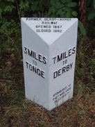
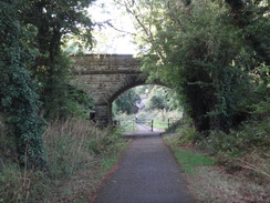
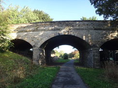
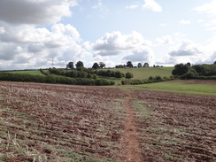
The next few miles followed the trackbed south; there was not many signs of the old railway, aside from some modern mileposts measuring the distances between Derby and Tonge. The surface was tarmac, and the going was easy. The old bridges seemed magnificent, with many having three stone arches so common on old Midland Railway lines – for some reason I always find these attractive. A few joggers and cyclists passed, but there was little of note until I passed the site of an old station that was still largely intact despite having lost its passenger services the best part of a century earlier.
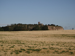
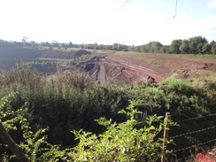
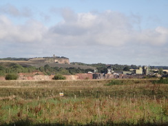
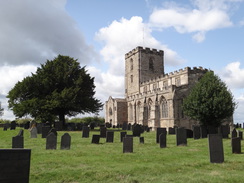
Eventually the old railway trackbed was left as the A42(T) dual carriageway was approached, which cuts the old line into two. A track led up to a local road leading down from Breedon-on-the-Hill, and to my right was a startling sight - a church sitting at the top of a cliff, the hillside below it having been removed by Breedon Quarry. The local road led back down to the old railway line, which I followed past the massive Cloud Hill Quarry. The bulk of this lay out of sight behind a fence and below trees, but occasional glimpses allowed me to see nearly to the bottom - and it seems vast.
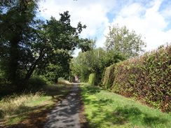
The railway path ended soon afterwards, and I took a surfaced path that was not shown on my map, but which carried part of the National Cycle Network south past Worthington. This ended at another track, which in turn soon ended at a road. The next few miles followed roads south towards the oddly-named village of Griffydam and then on to the larger village of Thringstone. This village had a nice feature: large blue plaques stating some of the history of select buildings. One used to be a blacksmiths; another a school whose head was the first soldier killed on the home front in world war one. The plaques added a little life to what otherwise might have been a rather ordinary village.
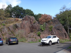
I had not eaten anything today, so I nipped into a Co-Op to buy a pack of sandwiches which I munched as I followed roads southeastwards towards Whitwick. A bit of a slog uphill led to a road that I had reached on a previous walk, where I sat down on a bench for a minute to take a stone out of my boot. The road led back downhill, and I made a slight mistake by taking another road that led towards a brick church. I soon realised that this road would take me back to where I had just walked, so I turned around and found the proper route. On the way there was a massive outcrop that stretched behind houses – perhaps a sign of historic coal or mineral mining.
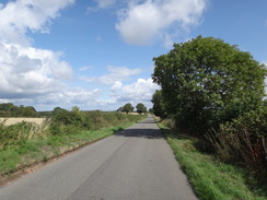
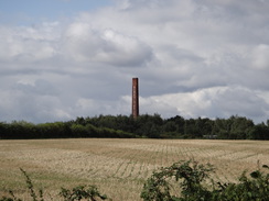
Roads took me through Thringstone, and then a slightly busier one past Swannington Common to Peggs Green and Geismoor. It was all rather uneventful walking along roads, and soon I reached Newbold, where a large chimney to the west was marked with 'Newbold Brick'. This area of Leicestershire and Derbyshire has been mined for coal for centuries, and some outcrops lay right at the surface - there was a 'pit' here as early as 1520. The chimney is on the site of the New Lount colliery, which opened in 1924 to exploit shallow coal seams. The presence of the mine, and its forward-thinking manager, Frank Hodges MP, meant that Newbold was one of the first villages in the country to have electric lighting. The colliery closed in 1968, although an open-cast mine was opened for a short period in the 1980s. The Newbold Brick Company, builder of the chimney that still stands, was opened in the early 1930s using local clay and coal to create bricks and pipes.
Aside from the chimney, there was little sign remaining of all this industry, and it seemed like just an ordinary, quiet village. A woman was striding purposefully towards me, her walking poles clacking on the tarmac as she approached. We stopped to chat for a minute, and it turned out she was practising for a 50 kilometre walk in the Peak District next week - I hope it goes well for her.
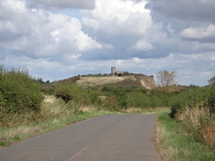
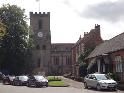
Another road led north out of the village, reaching Worthington, which it skirted to the west. I had skirted to the east of it earlier on this walk, and on neither occasion did I actually enter it. Another road headed north, passing the abutments of an old railway bridge on the same line I had followed earlier, and then passed near to the massive Cloud Hill Quarry before crossing the A42 dual carriageway on a high bridge and on into Bardon-on-the-Hill. This little village is dominated by the church that sits on top of what was once a hill, and is now half-a-hill.
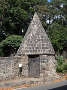
I had planned to walk along the west side of the hill, but the church and cliff looked just to tempting not to visit. By the main road in the village is a beautiful stone circular building with a high conical roof, which is an old lock-up. This was quite magnificent, if small, and I wished I could look through the wooden door (if not inhabit it), but sadly I had to continue on along a road, and then a path, that led steeply up the hill towards the church.
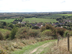
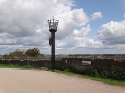
Grand views unveiled themselves from the summit; initially east over the quarry, past a large fence designed to stop people falling over the edge, and then north and west towards Derbyshire and Staffordshire. I paused and admired the views near a jubilee beacon, trying to make out the landmarks shown on a board. It was a little too hazy to make out the most distant ones, such as Crich, but it was a grand view nonetheless.
The church's access road took me down the hill, before a local man pointed me to a footpath that led steeply downhill through trees - steeply enough that walking poles would have come in handy. He also told me that I should take a footpath that crossed the 'old' golf course. I found the right footpath and started across the greens, but something looked a little wrong: everything was a little too unkempt. A sign stated that the footpath was well marked, but after a couple of posts I had to use dead reckoning, which I fortunately got right. I get the impression that the golf course has not been used for a while, although a matter of months rather than years, as it was not only empty on a Saturday lunchtime, but also could have done with a good mow.
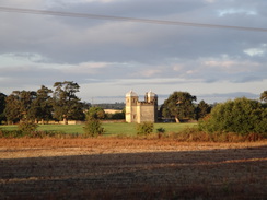
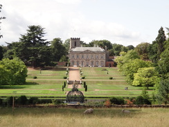
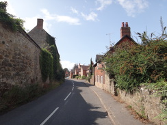
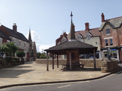
The path left the golf course and ascended and descended a hill, before settling down and passing an unexpected, beautiful glimpse of Melbourne Hall. Despite having had family in the area all my life, I've only ever paid cursory visits to Melbourne, and have never visited the hall that seems to dominate the village. That would have to wait, as my parents were waiting for me in the centre of the village. A road led uphill towards the market place, where an attractive square shelter seemed as good a place as any to wait, directly opposite my favourite cake and savouries shop, Birds Bakery.
It had been a surprisingly enjoyable stroll, where the area's industrial past was rarely far from view.
I would like to dedicate this walk to my late uncle, Simon Heath.
 |
 |
|
Directions
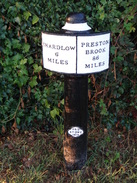
This walk starts off at the junction between Church Lane and Twyford Road near Barrow-on-Trent church at SK35322854. Head north up Brookfield, passing the Brookfield pub on the right, until the road soon ends at the A5132 road. Carefully cross the main road, turn right for a few metres and then left up another road, Sinfin Lane. This climbs to cross a bridge over a railway line, and continues on a few metres towards a canal bridge (number 16). Just before the canal bridge, turn right down some steps to meet the towpath of the Trent and Mersey canal at SK35512899.
Head straight on eastwards along the towpath. It passes the entrance to the Derby Canal over the water and the adjacent Swarkestone Lock, and after 4.1 kilometres an old railway bridge over the canal (number 11a) is reached at SK38902779. A path leads off to the right just before the bridge, climbing up onto an old railway line that runs over the canal. The trackbed now carries the Cloud Trail. Follow the trackbed and trail south; it soon crosses an en elegant bridge over the River Trent. Continue south as the trail passes through King's Newton, Wilson and Tonge, although the villages mostly remain out of view. After 6.6km thee old railway line is interrupted by the A42(T) dual carriageway. Follow the cyclepath as it curves right and slowly climbs up along a track. After 300 metres some steps lead up to reach a road at SK41022230.
Step across the safety barrier and turn left to follow the road across a bridge over the A42(T) dual carriageway; there is a pavement on the left. Follow the road as it curves left and descends downhill, before the pavement splits away left from the road, descending down to rejoin the course of the old railway line. At the bottom, turn right to head under the bridge that carries the road overhead, and follow the old railway south, passing close to the western edge of the massive Cloud Hill quarry. After 1.1km a car park is approached ahead at SK40762101.
Just before the car park is reached, turn left along a surfaced cycle path that carries National Cycle Route 6. This soon curves right to head south through trees, initially alongside the edge of the quarry; after 500 metres the track turns sharply left and climbs uphill for about 300 metres before ending at a T-junction with another track. Turn right to follow this track south for nearly 400 metres until it ends at another T-junction with a road at SK41262029.
Turn right along the road for a few metres, and then left to head south down a road. After 1.2km this road ends at a T-junction with the B5324 immediately to the north of Griffydamm, beside an old chapel. Turn left to carefully follow the road uphill; there is no pavement, but the verge on the right was reasonably wide. At the top of the hill, after 150 metres, turn right down a road for a few metres, and then left to start down Stordon Lane. This winds around in a rough southesterly direction, and after 1.5km ends at a triangular junction with the A512 at SK42391827.
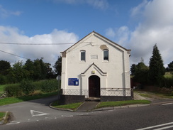
Carefully cross the main road, and turn right to follow it around a left-hand bend. Pass the George and Dragon pub on the left, and then immediately turn left down another road, Lily Bank, immediately passing the side of the pub on the left. The road curves right and then left, entering Thringstone, and a pavement starts on the right as it becomes Main Street. 1.4km after the pub, the road ends at a dead-end. Pass some bollards and continue along the pavement alongside The Green on the left for a short distance until Gracedieu Road leads off to the left at SK42781707.
Turn left along Gracedieu Road; this heads east before curving to the right to take a more south-southeasterly course into Whitwick; after 850 metres the road passes the Hare and Hounds pub and ends at a T-junction. Turn left to head eastwards up Loughborough Road for 550 metres until Cademan Street leads off to the right. Turn right to head down Cademan Street; it eventually curves left, and after nearly 600 metres turn right down Skinners Lane, which passes the side of a Co-Op store. The road soon ends: continue on for a few metres to reach Market Place. Turn right to follow the road northwestwards, becoming North Street. After a kilometre, Talbot Lane leads off to the left at SK42831686.
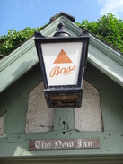
Turn left along Talbot Lane; this heads northwestwards, then curves left beside Talbot House Farm and then right; after 1.5km the road climbs to end at a T-junction with the A512. Carefully cross the main road, and on other side head straight on down New Road into the village of Peggs Green. This road soon ends at another T-junction with Nottingham Road. Turn right up Nottingham Road, and as it curves right after 50 metres, turn left down Zion Hill. This passes the New Inn on the right, and becomes Gelsmoor Road. After 1.1km the road ends at a T-junction with the B5324 at SK40401837, with the Gelsmoor Inn a short distance away to the right.
Carefully cross the road and heads straight on along a footpath that runs along the course of an old road. Continue along the path as it descends slightly to pass some new houses on the left, after which it becomes an access road and then climbs; ignore a road off to the left. After 200 metres the old road ends at a T-junction with School Lane in Newbold. Turn right to follow the road as it winds north into Newbold; it leaves the village and continues on. After 2.3km it enters the outskirts of Worthington and ends at a T-junction at SK40602065.
Carefully cross the road and head straight on down Breedon Lane. This crosses the A42(T) and after 2.3km ends at a T-junction in Breedon-on-the-Hill. Turn right along Main Street, and on a slight left-hand bend, and just before an old lock-up with a conical roof, take the first road to the left, The Delph, which climbs steeply uphill. The road passes a stone wall on the left, and as it curves left at the top of the hill, turn right up a track that heads steeply uphill to the northwest. When the track forks, take the right-hand branch, which soon meets another path. Turn right up this path and follow it uphill; at the top go through a squeeze-gap to reach a car park beside Breedon-on-the-Hill church at SK40592327.
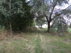
Follow the car park around to the left, with the church and churchyard away to the left. Pass a beacon on the right to reach a step-stile by the main gates. On the other side, continue along a surfaced track as it heads north past the churchyard on the left, with a quarry hidden behind trees on the right. The track curves sharply to the left; soon after the bend turn right down a path that plunges steeply down westwards through the trees, following a fence on the right. This path soon meets a small lane, and curves right to fall gently alongside the lane. A short distance along the lane at SK40442357, turn left to cross the road and go through a (broken in 2018) clapper gate.
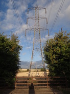
The gate leads onto a golf course. Follow a track northwestwards, initially between hedges. When the hedges end continue northwestwards across the golf course; the path is indistinct on the ground but eventually follows a band of tree on the left as it gently falls. At the end of the golf course, go through a pedestrian gate through a fence and continue on down a slope. Head under some power lines to reach another pedestrian gate that leads onto a road at SK40012412.
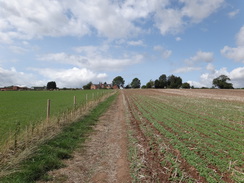
Turn right down the road for a couple of metres, and then left through a gap in a hedge to enter a field. Follow a fence on the left uphill across the field, aiming for the right-hand side of a house at the top. The fence on the left is replaced by a wall of an outhouse and then a hedge, which leads to a track. Cross the track and then a stile to enter another field. Follow a fence on the left for a few metres, and then turn half-right to angle diagonally downhill across the field, aiming for bottom right-hand corner at SK39622456.
At the corner, go through a field gate into a field; ignore a good track leading off ahead, and instead angle right across a path that climbs up a slope across the field. At the end of the field squeeze through a gap in a hedge and then cross a stile to enter another field. Angle slightly left across this field to reach a pedestrian gate. Go through the gate and then angle slightly left to cross the field diagonally, with Melbourne Hall away to the left. At the far side go through another pedestrian gate that leads into a grassy area with a hedge to the left. The path curves slightly to the right away from the hedge on the left. It then enters a small area of trees to reach a clappergate beside a field gate that leads out onto a road at SK39222510.
Turn left to start following the road westwards into Melbourne; after 650 metres the Market Place is reached with an attractive shelter on the left at SK38632518, where this walk ends.
 |
 |
|
Distances
| From | To | Distance (m) | Ascent (ft) | Descent (ft) |
|---|---|---|---|---|
| Barrow-on-Trent | Tonge | 6.5 | 131 | 59 |
| Tonge | Whitwick | 6.6 | 646 | 384 |
| Whitwick | Newbold | 3.0 | 259 | 328 |
| Newbold | Melbourne | 5.0 | 436 | 607 |
This makes a total distance of 21.1 miles, with 1472 feet of ascent and 1378 feet of descent.
For more information on profiles, ascents and descents, see this page
Transport
Until a month or so ago, there were regular (usually hourly) bus services between Melbourne and Barrow-on-Trent, o the way to Derby. Sadly these have been cut bck to just two or three a day, and those are at inconvenient times. Therefore, if the bus services have not been reinstated, you might need to extend the walk back to Barrow by the Cloud Trail, or rely on taxis.
 |
 |
|
 |
 |
|
 |
 |
|
 |
 |
|
 |
 |
|
 |
 |
|
 |
 |
|
 |
 |
|
 |
 |
|
 |
 |
|
 |
 |
|
 |
 |
|
 |
 |
|
 |
 |
|
 |
 |
|
 |
Disclaimer
Please note that I take no responsibility for anything that may happen when following these directions. If you intend to follow this route, then please use the relevant maps and check the route out before you go out. As always when walking, use common sense and you should be fine.
If you find any information on any of these routes that is inaccurate, or you wish to add anything, then please email me.
All images on this site are © of the author. Any reproduction, retransmissions, or republication of all or part of any document found on this site is expressly prohibited, unless the author has explicitly granted its prior written consent to so reproduce, retransmit, or republish the material. All other rights reserved.
Although this site includes links providing convenient direct access to other Internet sites, I do not endorse, approve, certify or make warranties or representations as to the accuracy of the information on these sites.
And finally, enjoy your walking!
Nearby walks
| # | Title | Walk length (miles) |
|---|---|---|
| 64 | Long Eaton to Willington | 14.0 |
| 68 | Willington to Doveridge | 12.6 |
| 581 | Burton-on-Trent to Derby | 16.3 |
|
|

|