Walk #20: Waterbeach to Ely
 |
 |
|
General Data
| Date Walked | 08/05/1999 |
| County | Cambridgeshire |
| Start Location | Waterbeach |
| End Location | Ely Station |
| Start time | 11.30 |
| End time | 15.20 |
| Distance | 12.2 miles |
| Description | I did this walk with a friend of mine, Mandy. It followed the western bank of the River Cam northwards. |
| Pack | Today I carried full kit, hopefully the same kit that I will be carrying on the Pennine Way. |
| Condition | I generally feel okay after this walk. |
| Weather | Today was warm, but overcast at times. It remained dry. |
| OS map | Landranger number 154 (Cambridge & Newmarket, Saffron Walden) and Landranger number 143 (Ely & Wisbech, Downham Market) |
Map of the walk
Maps courtesy of Google Maps. Route for indicative purposes only, and may have been plotted after the walk. Please let me have comments on what you think of this new format. For a detailed table of timings for this walk, please see the table file.
Notes
I had a friend staying over for the weekend, and we decided to do a walk together along the River Cam towards Ely. This is becoming my 'standard' training walk; there are few hills to be climbed, but it is good practice nonetheless. It felt slightly strange to be walking with someone, but Mandy's company was superb and the miles flew by.
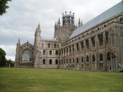
There is something almost magical about how Ely Cathedral appears on the horizon as you approach it; the reasoning behind its nickname of 'the ship of the Fens' is obvious when approaching by this route.
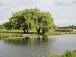
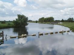
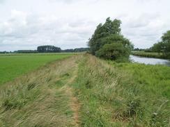
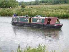
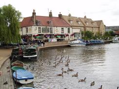
Please note that the photographs on this page were taken on a later walk, walk 611 in 2004.
 |
 |
|
Directions
This is a simple, flat but quite picturesque walk along the western bank of the River Cam / Great Ouse, mostly following the Fen Rivers Way.
From the village of Waterbeach make your way to Bottisham Lock. Just before the lock is reache turn left and take the road 'Long Drove' that heads for three miles directly northwards. After three miles (and near the end of the tarmacced road) there is a green lane (although usually brown!) called Black Drove heading off to the east towards the river. Follow this and climb onto the banking beside the river. There is a good information sign here giving information on the flora and fauna of the river.
The rest of the walk is fairly easy; just continue following the Fen Rivers Way as it heads northwards; for most of the time this follows the top of the flood banking, but in a couple of places it drops down onto the floodplain and follows the riverbank for short distances. These places are well marked, and continuing onwards along the flood bank would be hard through many years' worth of vegetation. The only problem comes at the point where the Cam and Great Ouse rivers meet; here a nice arched footbridge arches over the Ouse, and allows you to cross the river safely. A couple of miles further north there is a little inlet that needs crossing; simply follow it inland to the railway line and a path crosses the inlet using the side of the railway embankment.
A kilometre further on the Ely to Bury St Edmunds railway line is crossed, and then it is a short walk to the A142 road in Ely. Ely Station is now a hundred yards to the left, but if you want to explore Ely a little more cross the road and continue on northwards along the river. The path dives under a railway bridge and past a couple of marinas before reaching the Maltings, which is now a prettified commercial area, with some lovely views along the river. Walk past the Maltings for a short distance before turning to the left to head northwards along Waterside; this soon joins Fore Hill, which can be followed uphill to the market place. Continue straight on, with the war memorial built into the wall on the left, until a gateway is reached on the left. Go through this gateway to gain access to the cathedral. Once through the gate turn right, and walk along the side of the cathedral to reach the main entrance at the western end.
Explore the cathedral and the surrounding area if you want, and then turn left to walk southwards along The Gallery, passing the Bishop's House and King's School, until a gateway is reached in the wall to the left. Walk through this gateway, and follow a broad path that heads downhill to the east until it emerges out onto Broad Street at the bottom of the hill. At Broad Street turn right to head southwestwards for a few hundred yards until it ends at Station Road. Turn left along Station Road, pass a roundabout and then cross over the road using a pedestrian crossing. The entrance to the station is a few yards away on the right; this is where the walk ends
Distances
| From | To | Distance (m) | Ascent (ft) | Descent (ft) |
|---|---|---|---|---|
| Home in Waterbeach | A1123 road | 5.5 | 3 | 13 |
| A1123 road | Ely station | 6.7 | 98 | 92 |
This makes a total distance of 12.2 miles, with 101 feet of ascent and 105 feet of descent.
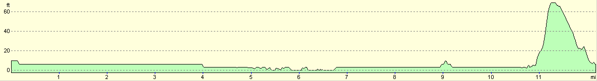
For more information on profiles, ascents and descents, see this page
Transport
There are regular (even on Sundays) trains from Ely to Waterbeach. The price of a single ticket is £3.00, and it costs £1.00 to park at Waterbeach Station at weekends, a short distance away from the start of the walk.
 |
 |
|
Disclaimer
Please note that I take no responsibility for anything that may happen when following these directions. If you intend to follow this route, then please use the relevant maps and check the route out before you go out. As always when walking, use common sense and you should be fine.
If you find any information on any of these routes that is inaccurate, or you wish to add anything, then please email me.
All images on this site are © of the author. Any reproduction, retransmissions, or republication of all or part of any document found on this site is expressly prohibited, unless the author has explicitly granted its prior written consent to so reproduce, retransmit, or republish the material. All other rights reserved.
Although this site includes links providing convenient direct access to other Internet sites, I do not endorse, approve, certify or make warranties or representations as to the accuracy of the information on these sites.
And finally, enjoy your walking!
This walk was mentioned in the following routes:
| A walk around East Anglia |
Nearby walks
| # | Title | Walk length (miles) |
|---|---|---|
| 11 | Stanton Moor | 2.9 |
| 12 | Darley Dale, Stanton Moor and Rowsley | 8.7 |
| 14 | Friden, Long Dale and Gratton Dale | 7.8 |
|
|

|