Walk #249: Gibraltar Point to Boston
 |
 |
|
General Data
| Date Walked | 28/10/2002 |
| County | Lincolnshire |
| Start Location | Gibraltar Point North car park |
| End Location | Boston Station |
| Start time | 07.05 |
| End time | 16.20 |
| Distance | 24.7 miles |
| Description | This is a long walk following the sea banks along the western side of the Wash and then up the Haven into the centre of Boston. |
| Pack | Today I carried my 30-litre Karrimor HotRock rucksack, which was filled with my packed lunch, waterproof coat, water bottle and a couple of spare shirts, together with the usual assortment of odds and ends. |
| Condition | The weather today was quite nice, particularly as the high weinds of yesterday had been replaced with much more manageable light breezes. Initially the sky was mostly sunny, but as the day went on it started to cloud iver, although there was not any sign of any rain. When the sun was in and the wind gusted I felt slightly chilly, but fortunately such occasions were far and few between. |
| Weather | I feel absolutely fine after this long walk, aside from the usual fatigue. I have no real problems, including yet another day with no blisters. The Compeed on the ball of my left foot has sorted out the hotspot that had been developing, and all in all everything seems okay. |
| OS map | Landranger number 122 (Skegness & Horncastle) and Landranger number 131 (Boston & Spalding) |
 |
 |
|
 |
 |
|
Map of the walk
Maps courtesy of Google Maps. Route for indicative purposes only, and may have been plotted after the walk. Please let me have comments on what you think of this new format. For a detailed table of timings for this walk, please see the table file.
Notes
It was with some trepidation that I looked out of the van window this morning after the high winds of yesterday. The news on TV stated that six people had died in the worst storms for ten years, so I was glad that I made the decision to cut the walk short. When I did look out of the window I was greeted with a nice sunny day, surprisingly with scarcely a hint of any wind. This cheered me up no end, and I resolved that I would try to walk as far as I could today.
The first obstacle of the day was the River Steeping, which I had to cross in order to gain access to the sea bank. If I had stuck to public routes then I would have had to walk inland for a few miles to get over it and then out the other side; I wanted to avoid this if possible so I went to explore the area around the river opposite Gibraltar Point. A couple of the other books mention a locked bridge over the river, and in her book Spud mentions that a local opened it for her. When I got to the bridge I was faced with an outer mesh gate beside a house that proved a trifle to climb over. The bridge, however, looked much harder as the gate was shockingly similar to the one at Tyninghame I had failed to climb early on in the walk. I looked at the gate for a few minutes and tested its stability before gingerly and very carefully climbing over. After a few minutes I had managed to get myself fully over it and down onto the other side. This was a fairly dangerous manoeuvre, and one that I would not recommend anyone to do, but I must admit that I did find it fun!
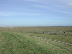
Just to the northeast of the little village of Freiston Shore I came across an area of land where the sea banks had had three large gouges taken out of them to allow the area to flood. This is part of a national scheme where some sea defences are being removed to allow the creation of new areas of salt marsh. This particular area is not very large, and the inland diversion by the car park was not very long or convoluted.
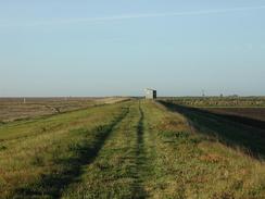
The next section of the walk was along the long stretch of sea bank that heads south-westwards. This soon became MOD land, part of the Wainfleet ariel bombing range. I walked along the banks past various ominous warning signs until I got to a place where the sea bank headed inland towards the second line of sea banks alongside an inlet. On the other side of the inlet there was an ominous military building, so instead of going back to the outermost bank I decided to walk along the second one. I followed this for a few miles, passing a large control tower on the way, before eventually meeting up with the first wall once more beside a military building near The Horseshoe. When I got there it looked as though I could have walked along the sea bank the whole way without diverting inland slightly, but at the time I had felt that what I had done was right.
Unfortunately on this walk I came across many dead seals which were probably victims of the distemper that is killing them at the moment. The first seal I came across I smelt before I saw it - it was badly decomposed and was far from a pretty sight. The others were thankfully less decomposed, but still a tragic sight to see dumped so mercilessly by the high tide against the sea banks.
Directions
This walk starts off at the north car park at Gibraltar Point. Leave the car park and turn left to walk south along the road. When you get to a track that leads off to the right, walk down this track and when it forks after a hundred yards take the left-hand fork, which follows an earth bank on the left.
This track soon ends at a large mesh gate beside a house. On the other side of the gate is a sluice and a bridge over the Steeping River; this bridge is the nearest crossing of the river to the sea; the next one involves a diversion of several miles to the sea. The route I describe here is obviously illegal and slightly dangerous; it is up to you if you decide to do it.
The mesh gate is easy to climb over; the gap in the mesh for the bolt and lock makes a good foothold. The bridge is a different proposition; there is a locked gate at one end that is climbable with extreme care, as there are nasty spikes located all over the gate. On the other side of the bridge continue straight on down the western side of the Steeping River.
Pass a pump house and continue on as the sea bank leaves the river and turns to the right to head westwards for a short distance before turning once again to head south-westwards along the edge of the Wainfleet Sands. After a couple of miles the path turns sharply to the right to head inland for a few hundred yards where a drain enters the marshes. At this point you can either choose to walk back along the other side of the drain to the sea bank, where there is an RAF bombing range, or you can turn left and walk along the second, more inland, sea defence.
Follow the sea bank as it heads south-westwards for a few miles, along paths that vary from non-existent to tarmac tracks. The banks passes right underneath an RAF control tower before eventually meeting up with the outermost sea bank once more by an RAF observation post near The Horeshoe.
When the sea banks join continue on along it, still in a south-westerly direction, for a few miles, passing Sailor's Home, until you are next to a pump house directly to the east of the little village of Leverton Outgate. Here the footpath continues south-westwards along a sea bank, but another sea bank heads off to the left for a short distance before turning to the right to head south-westwards. This is the outermost sea bank, and is the one I followed even though it does not have a footpath running along the top of it. Follow this sea bank as it heads south-westwards for a few miles, passing another pump house before reaching another sea bank coming in from the right.
Although the sea bank appears continues on to the southwest it has actually been removed in three places; therefore it is best to turn to the right and walk down the sea bank to a little car park. At the car park turn left and walk down another sea bank past the new area of marshland towards the village of Freiston Shore. Once past the marshland turn left along another sea bank back towards the sea and then turn right to continue along the outermost sea bank.
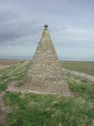
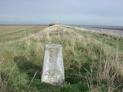
This sea bank then continues on in a more southerly direction with a large expanse of marshland leading to the Wash on the left. It passes a conical stone monument that is dedicated to the memory of the builders of the sea banks, and finally ends at a T-junction with a footpath at the north side of the Haven beside a trig point.
Turn right and walk westwards along the footpath at the top of a sea bank to the north of the Haven. This path passes a little house and a car park at Cut End before slowly turning to a more north-westerly heading and crossing a sluice over a large drain. The path continues on, skirting a road and passing a monument to the Pilgrim Fathers before passing a sewage works.
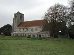
The path continues on to the northwest, passing between the river and a large industrial building before meeting a large surfaced track. The path continues on the bank between the river and this track and passes under a set of power lines. When the path reaches a beacon turn right past some gates and head northwards through the grounds of a church until a road is met. Turn left along this road and follow it as it crosses over a large drain and passes just to the left of the distinctive Hussey Tower. When the road ends at a T-junction with a main road turn right and follow it for a short distance until an section of dual carriageway is met with a bridge to the left.
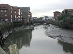
Cross over the dual carriageway and continue straight on up another road with the river on the left until you get to a roundabout. At the roundabout turn left and cross the river over an attractive bridge. On the other side of the bridge head through a little narrow alley which ends at a road. Turn right along this road and follow it to a level crossing. The railway station is a short distance to the right down Station Approach from this crossing.
Distances
| From | To | Distance (m) | Ascent (ft) | Descent (ft) |
|---|---|---|---|---|
| Gibraltar Point | Sailor's Home | 10.3 | 16 | 20 |
| Sailor's Home | The Haven | 8.1 | 33 | 33 |
| The Haven | Boston Station | 6.3 | 30 | 30 |
This makes a total distance of 24.7 miles, with 79 feet of ascent and 83 feet of descent.
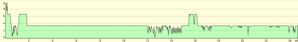
For more information on profiles, ascents and descents, see this page
Accommodation
We stayed at the White Cat Caravan and Camping Park, Shaw Lane, Old Leake, Boston, Lincolnshire, PE22 9LQ, and telephone 01205 870121. They can be emailed at whitecatpark.com. This site cost us seven pounds fifty for the night, and was reasonable for that cheap price. The showers were warm, but they are in a separate part of the building to the toilets and were hence slightly cold, which was fixed by leaving the shower on to warm the room up for a few minutes before I got undressed.
Disclaimer
Please note that I take no responsibility for anything that may happen when following these directions. If you intend to follow this route, then please use the relevant maps and check the route out before you go out. As always when walking, use common sense and you should be fine.
If you find any information on any of these routes that is inaccurate, or you wish to add anything, then please email me.
All images on this site are © of the author. Any reproduction, retransmissions, or republication of all or part of any document found on this site is expressly prohibited, unless the author has explicitly granted its prior written consent to so reproduce, retransmit, or republish the material. All other rights reserved.
Although this site includes links providing convenient direct access to other Internet sites, I do not endorse, approve, certify or make warranties or representations as to the accuracy of the information on these sites.
And finally, enjoy your walking!
This walk was mentioned in the following routes:
| My walk around the coastline of Britain |
Nearby walks
| # | Title | Walk length (miles) |
|---|---|---|
| 180 | Mablethorpe to Skegness | 15.6 |
| 181 | Boston to Fosdyke Bridge | 11.6 |
| 247 | North Somercotes to Skegness | 24.4 |
|
|

|