Walk #360: Instow to Saunton
 |
 |
|
General Data
| Date Walked | 18/02/2003 |
| County | Devon |
| Start Location | Instow |
| End Location | Saunton |
| Start time | 07.54 |
| End time | 16.00 |
| Distance | 20.3 miles |
| Description | This was a lovely walk, and for the first time 8in weeks it was a walk with virtually no ascents or descents. |
| Pack | Today I carried my 30-litre Karrimor HotRock rucksack, which was filled with my packed lunch, waterproof leggings, water bottle and a couple of spare shirts, together with the usual assortment of odds and ends. |
| Condition | I feel absolutely fine after this walk, and I could easily have walked further if I had so desired. No part of my body ached at any time today, which is nice given that I did a relatively long day. I wore my trainers for the majority of he walk as far as Branton, and my boots for the remainder, which may explain why my ankle did not give me any trouble. |
| Weather | The weather today was very much as it has been for the last few days; very cold initially with a heavy frost, followed by sunshine and a bitterly cold wind. The main difference today was that there was slightly more cloud in the sky at times, and the wind was stronger, particularly in the afternoon. |
| OS map | Landranger number 180 (Barnstable & Ilfracombe, Lynton & Bideford) |
 |
 |
|
 |
 |
|
Map of the walk
Maps courtesy of Google Maps. Route for indicative purposes only, and may have been plotted after the walk. Please let me have comments on what you think of this new format. For a detailed table of timings for this walk, please see the table file.
 |
 |
|
 |
Notes
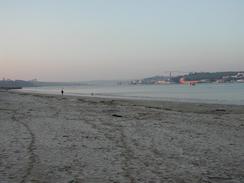
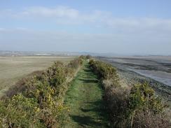
I very much enjoyed today's walk, and am exceedingly pleased that I managed to walk for more than twenty miles. The walking was very easy today, with over half of the walk being on cycle tracks running along old railway track beds, and the other half being along flood banks and tracks past huge sand dunes. As a consequence of this, today was the first day in weeks when I have had a day's walk with no real noticeable ascents or descents - today was nearly all flat. For some time I have been slightly concerned that I have been walking at a slower pace, especially when I compare the time it took me to do sixteen miles in (say) Suffolk to the time it has taken me recently. I thought that I could explain this by the fact that the walks for the last couple of months have involved much ascents and descents, but I still had a nagging doubt that I was walking slower than I was earlier in the walk. Fortunately today has disproved this, and I kept up a decent pace (for me), and any slowing down must have been caused by the hills.
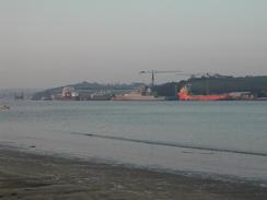
I set off early today, as I knew not only that I had a long distance to walk but I also wanted to do some shopping in Barnstaple, which was the first big town that I have walked through for a few days. The plan was for Sam to drive to Braunton and then cycle down the cycle tracks to meet me near Barnstaple. However before I could get to Barnstaple I had to walk six miles into the town, and this was where the only problem of the day reared its head. As I joined the cycle track I read a notice saying that it was closed for resurfacing works along a long stretch from Instow to Fremington Viaduct. There were no real alternatives to the cycle track along this long section and I decided it was best to cope with construction equipment rather than the traffic on the main road. Near the site of the old power station I came across a JCB, and I waited until the driver had seen me and then approached for a chat. He said it was okay to go on, and that there were two lorries and a paving machine further on. I soon reached these, and carefully passed them by walking in the cess for the small section that they were working on. After this I had a lovely walk along fresh tarmac all the way into Barnstaple.
Sam met me just before I reached the town, and I walked as she rode her bike into the town. We then had various things to do for a while - my nephew's birthday is in a few days, so we got him a card and a present, and of course all the walking shops were visited. Barnstaple is a pretty little town, and I enjoyed walking around it, studying some of the architecture on the buildings as I did so. Eventually we left the town and continued on along the cycle track (which is also part of the Tarka Trail as well as the South West Coast Path) to Velator Bridge in Barnstaple, where Sam had parked Mervan. It also proved to be a good place to eat my lunch out of the wind that was quite chilling - I did not want to have to stop outside in the wind if I could possibly avoid it.
The next section southwards from Velator Bridge took me along the flood bank of the River Caen, and it was on this section that the wind was most noticeable. It was strong and gusting, and caused me to walk crab-like during the strongest gusts. I met a couple walking in the opposite direction, and they confessed their gladness that they were walking with the wind rather than against it! Once I had dropped off the flood bank at Pill's Mouth (where the path turns to head westwards to the White House) I was much more protected from the wind, and I could make better progress as far as the car park. As I was walking through the car park (which is unsurfaced) I came across a small campervan that was stuck in the sand. I went over to see if I could help, and I found a woman, her baby and a lovely dog in the van. The front wheels were on firmer ground, but the rear, driving wheels were well bogged down. She was going to call someone to come and pull her out, but I offered to help her. Initially we attempted to rock the van out of the hole, but she was not good enough at using the clutch and gears and stalled the van. I therefore got stubborn and lay down on the sand and kicked a large trench out in front of both of the rear wheels. This worked, and the van drove out of the resultant hole. The lady gave me a few quid for my collection pot as a thank you, and I set off happy at having done a good deed for the day.
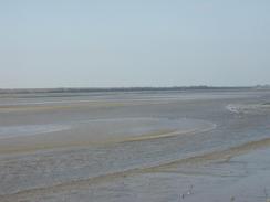
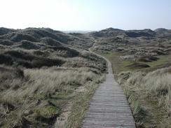
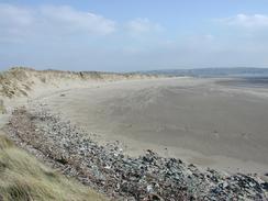
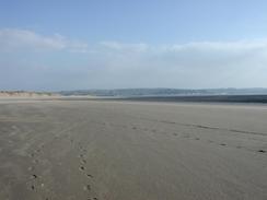
I made a slight diversion from the car park along the boardwalk to the beach, before returning and following the path past the sand dunes to the main road in Saunton. This part of the track was probably the hardest walking of the day, as it was very muddy and quite slippy in places. The dunes of Braunton Barrows were very visible to the left, as was a search and rescue helicopter that kept on flying overhead from its base at Chivenor airfield. The dunes are so big (many are thirty metres high) that a church is believed to be submerged under them somewhere in the Barrows! When I finally met Sam at the car park beside Saunton Beach she had been busy. She had needed to fill Mervan up with fresh water, and so she did her normal thing and visited a campsite to ask if she could fill it up. The gent kindly said yes, and also offered us a free spot for the night - his campsite was shut as it was out of season, but he let us stay in his yard and gave us power, which was indeed a kind act. This evening we went into his house and chatted to him for a few hours, and he was a very interesting man and it beat sitting in the van watching television.
The easy sections of walking have now finished, and the rest of the South West Coast Path involves much walking along cliffs. I have walked nearly all of this stretch before, so I know what to expect and am very much looking forward to it. Tomorrow I should get to Ilfracombe on a sixteen-mile day, and from there it is another couple of day to the end of the South West Coast Path. In a way I will be quite sad to see the end of this trail - I have been walking it for such a long time (nearly two months) that in some ways it is hard to remember when I was not walking it! The scenery has been fairly spectacular for most of the way, and has been far better than those long and dreary days along the sea wall in Suffolk and Essex.
Directions
| During this walk I followed the South West Coast Path, the route of which is detailed in the Ordnance Survey National Trail Guide 8, Minehead to Padstow (ISBN 1-85410-774-7). Unfortunately the route description is written in reverse to the direction that I am walking, but the 1:25,000 maps in the book are clear and the signs on the ground are very good. Also to be recommended is the South West Coast Path Association guidebook (ISBN 0-907055-04-4), which has less concise directions and no maps, but includes accommodation details and grades each section of the walk according to difficulty. They also publish reverse directions, which are suitable for walking in the direction that I walked the route. They have a website at www.swcp.org.uk, which is well worth a visit. | 
|
| 
| |
| |
| |
Distances
| From | To | Distance (m) | Ascent (ft) | Descent (ft) |
|---|---|---|---|---|
| Instow | Barnstaple | 6.8 | 223 | 233 |
| Barnstaple | Braunton | 5.2 | 102 | 98 |
| Braunton | Saunton | 8.3 | 262 | 213 |
This makes a total distance of 20.3 miles, with 587 feet of ascent and 544 feet of descent.
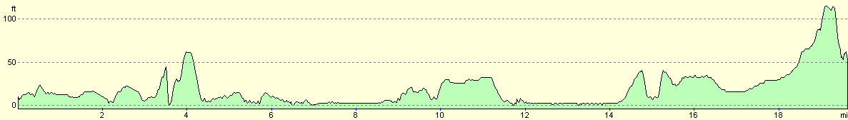
For more information on profiles, ascents and descents, see this page
Accommodation
We stayed at a farm in Heanton Punchardon, where the farmer allowed us to stay for free and gave us an electric hook-up, which was exceedingly kind of him.
Disclaimer
Please note that I take no responsibility for anything that may happen when following these directions. If you intend to follow this route, then please use the relevant maps and check the route out before you go out. As always when walking, use common sense and you should be fine.
If you find any information on any of these routes that is inaccurate, or you wish to add anything, then please email me.
All images on this site are © of the author. Any reproduction, retransmissions, or republication of all or part of any document found on this site is expressly prohibited, unless the author has explicitly granted its prior written consent to so reproduce, retransmit, or republish the material. All other rights reserved.
Although this site includes links providing convenient direct access to other Internet sites, I do not endorse, approve, certify or make warranties or representations as to the accuracy of the information on these sites.
And finally, enjoy your walking!
This walk was mentioned in the following routes:
| My walk around the coastline of Britain |
| South West Coast Path |
Nearby walks
| # | Title | Walk length (miles) |
|---|---|---|
| 87 | Horns Cross to Barnstaple | 17.2 |
| 88 | Barnstaple to Woolacombe | 11.9 |
| 89 | Woolacombe to Combe Martin | 13.0 |
|
|

|