Walk #749: Thames Path: Shepperton to Putney
 |
 |
|
General Data
| Date Walked | 12/11/2006 |
| County | Surrey, London |
| Start Location | Shepperton car park |
| End Location | Putney Bridge station |
| Start time | 08.12 |
| End time | 16.25 |
| Distance | 23.7 miles |
| Description | This was a long walk following the Thames Path as it winds through South London. |
| Pack | Today I carried my 30-litre Karrimor rucksack filled with my waterproofs, two litres of water, and various other odds and ends. |
| Condition | My feet ache after this walk, and I had a little trouble with my right knee, which has been giving me trouble over the last few walks. |
| Weather | Today was nice and sunny, and although it was initially cold it soon warmed up as the day wore on. There was little cloud and very litle winf at all. |
| OS map | Landranger number 176 (West London, Rickmansworth & Staines) |
 |
 |
|
 |
 |
|
Map of the walk
Maps courtesy of Google Maps. Route for indicative purposes only, and may have been plotted after the walk. Please let me have comments on what you think of this new format. For a detailed table of timings for this walk, please see the table file.
 |
 |
|
 |
 |
|
Notes
I had finished the last stretch of the Thames Path at Shepperton station, and I therefore had to get there to start the last stretch, which with luck will be the penultimate stretch of the trail. It had been my plan to drive down to Mile End and get the tube and train to Shepperton, but a late start meant that I ended up driving around the M25 to reach the start of the walk. Instead of stopping at the station, where I had ended last weekend's walk, I parked in a free car park by the village hall, which I had passed on the way to the station.
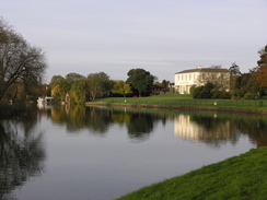
It did not take me long to pull all of my kit together, and I was soon walking down the road towards the war memorial in the village. On the previous Saturday I had walked this in the dusk, and it seemed a much nicer - if quieter - place on this Sunday morning. After passing the war memorial I walked the short distance to a car park in a park, where I had left the Trail on the previous walk, and started following the Thames Path. This went through the pleasant little park, before diving through trees to reach the river for a few yards; the views along the river are worth the diversion, with the white Manor House and its associated lawns contrasting with the blue water of the river.
The path then doubled back on itself to reach a road a short distance away from the park, and then followed a path alongside the road, passing near to a scout hut before joining the road proper, which led me on into Lower Halliford. I next saw the Thames as I crossed Walton bridge, which was fairly unusual; to the left was an old pedestrian footbridge slung off the road bridge, but this was now shut; the path followed the road bridge, whilst the road traffic now took the new road bridge to the right.
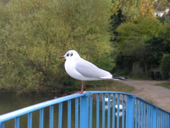
Once across the bridge I was greeted with some pleasant riverside view, an eight boat was passing under the bridge, the rowers rowing hard according to the coxes shouted instructions. The Trail then followed the river northeastwards through Walton-on-Thames; fairly soon it crossed a footbridge over the entrance to a marina, and there was a bird nonchalantly sitting on top of the handrail, allowing me to get very close for a photograph. Once down the bridge there were swans that seemed to be very much of the same mind, and I snapped several photographs before moving on.
The next item of any note was Sunbury Lock, the new one situated slightly downstream from an old one, of which I could see no trace. A short distance further on a high brick retaining wall started on the right, and the path squeezed between it and the river. On the other side of the long wall were the Moseley Reservoirs, although at no time did I actually see them. The wall itself was quite attractive, with the regular panels having inset lozenges in the brickwork, and half-brick ledges near the top and bottom - these little flourishes certainly made it more interesting than a plain brick wall would have been. About halfway along the wall there were some large, four-foot cube concrete blocks, the remains of Second World War tank traps - although I am unsure how tanks would have got to this point.
After the wall ended the river passed a little island, and further on a broad patch of grass started on the right - Hurst Park, where horse races were held for many years. The park was busy with walkers and joggers, and it was a pleasant enough stroll, with the views over the river being particularly pleasant. About halfway along the grass were some seats, and inset into these were some information boards - I was surprised to find that one of the first balloon flights in Britain occurred from Hurst Park, a short time after the Montgolfier Brothers managed the first ever flight.
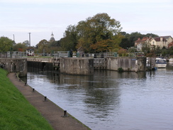
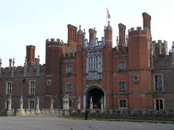
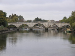
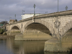
The park did not really end, and instead seemed to peter out; a short distance after this I came to Moseley Lock. The public toilets adjacent to the lock came in handy, and afterwards I took some photographs of the picturesque lock, before heading on to Hampton Court Bridge. The road across the bridge was busy, and I had to wait a couple of minutes for the lights to change to allow me to cross the road on the other side. The wait was worth it, however, as I was greeted with the sight of Hampton Court Palace.
The Trail followed the Barge Walk, from where there were some good views of the attractive palace. After a few yards a green Royal Parks Landrover passed me, and when I in turn passed it a couple of hundred yards further on I was surprised to find that there was a hole in the metal roof, with a circular lid on it - quite what this is for, I do not know. Although there were some good views of the palace from the Barge Walk, I probably did not get the best views from here, and the beautiful gold-inlaid gates that separated the formal gardens from the riverside were annoyingly fronted by some larger and less attractive fences.
As I walked along there were a few rowing boats on the river, the remains of a race that had been on the river earlier in the morning. A marshal was talking into a radio about the race as I passed, and I watched the rowers and the other river traffic as I walked along the wide path that followed the river as it looped around Hampton Court Park. As it headed northwards towards Richmond the scene became more built up, and after passing a ferry landing stage there were some nice views downstream towards Kingston Bridge.
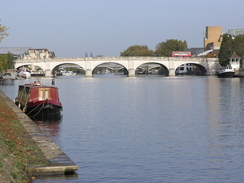
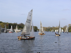
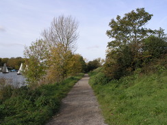
It is obvious that the area immediately around Kingston Bridge had been recently redeveloped, and there was a posh supermarket right beside the path as it headed down from the bridge to rejoin the river. A little further north there was a rail bridge, and beyond this there were a fair few sailing boats going around a loop in the river; it was entertaining watching them as they tilted over to take the sharp corner around a buoy; with several I was amazed that they did not get lots of water in them, they were so far tilted over.
After this there was a narrow road, with only a narrow gap left between the fishermen on the riverside and the parked cars on the right. This gap was just enough to allow cars along, but there was a bot of chaos when two cars met in the middle of the long stretch, and neither seemed willing to reverse. When this road curved to the right the Way stuck to the riverside, heading straight on towards Teddington Lock.
Teddington Lock is the first tidal lock on the Thames, and after this the river had a very different nature. The lock itself was very large, with boat rollers, a coffin (or skiff) lock, a launch lock and finally a barge lock. There was a little cafe next to the lock, and this seemed as good a place as any to stop for a break. I purchased a mug of hot chocolate and a lovely piece if chocolate cake, which were gladly welcome. Although the day was fairly sunny it was a chilly day, and the hot chocolate managed to warm me up nicely. For the next thirty miles to the source I had a choice; either to walk on the southern or northern bank of the river. I chose to do the southern bank, although I intend sometime to come back and do the northern bank (the National Trail follows both banks, so you can swap and change of you want).
I still had a long way to walk, and so I reluctantly ate quickly, put my tray away and headed on downstream. It immediately became obvious that here the river was tidal; there were some large mudflats to me left, and after a few yards there was a slightly overgrown pillar, a monument marking the limits of the powers of the Thames Conservators, who are in charge from the Thames all the way from Teddington to the source; further downstream, the river is the responsibility of the Port of London Authority.
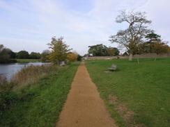
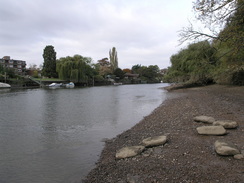
The path was quite rural as it headed downstream, crossing a footbridge over the entrance to the Thames Young Mariners water, an area where young people can yacht. Next came Eel Pie Island in the middle of the river, which must be a pleasant, if strange, place to live. Ham House dominated the views to the right, and shortly afterwards to the left I could see the beautiful white Marble Hill House. There were lots of people out walking as the path headed towards Richmond, eventually becoming more urban before Richmond Bridge was reached.
I stuck to the south bank of the river as I headed on, soon passing under a rail and then a road bridge, before reaching the strange Richmond Lock, which had a footbridge crossing high overhead. This is a half-tide lock, which is opened for a few hours every high tide, and unlike the other locks (which have weirs to allow the majority of the water past), this lock covers the entire width of the river. Shortly afterwards, Kew Park became visible on the right, and planes on the final approach to Heathrow flew low overhead, making me realise how much the Thames has looped through South London - it feels like only a few miles ago that they were flying overhead near Windsor.
The path curved around the Old Deer Park, and there were some pleasant views to be had over the river towards Isleworth and, shortly afterwards, one of the lodges of Syon House. It is a remarkably rural walk considering the fact that we are in the centre of London, and soon I could see the entrance to the Grand Union Canal on the other side of the river at Brentford. This brought many happy memories back to me, as when I had lived in London I had walked the Brentford branch of the canal on many occasions. The area around the mouth of the canal looked much more built up than I remembered it, and it looks as though (seemingly in common with much of the riverside in London) it has been redeveloped.
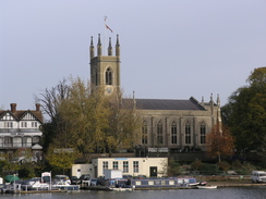
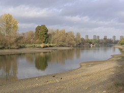
The red brick walls of Kew Palace soon became visible to my right, and this was followed by Kew Bridge itself. The walk through Kew was fairly pleasant, soon passing under a railway bridge and walking along a rural stretch past the Public Record Office to reach Chiswick Bridge. The Trail then followed the river to Barnes Bridge (a rail bridge), and by this time it was getting late in the day and I was starting to feel quite tired. It was also getting late in the day, and I started to seriously consider finishing the day's walk at Hammersmith instead of Putney Bridge. However I eventually decided against this, as it would add another couple of miles on the last day of the walk to get to the Thames Barrier, which was already going to be a fairly long day for the time of year.
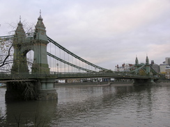
Instead I got my head down and continued following the river as it curved northwards and then northwestwards to reach Hammersmith Bridge. I resisted the temptation to cross here, and instead walked on, passing the Harrod's Furniture Depository on the right, and then having some reasonable views of the stands of the Craven Cottage ground of Fulham Football Club. Before I knew it I found myself at Putney Bridge, where the Trail headed away from the river slightly, heading inland a short distance to pass a smart pub in a redeveloped area to reach Putney Rail Bridge.
The skies were starting to get dark as I crossed the footbridge attached to Putney rail bridge, and consequently I could not get very good photographs downstream. With stiff legs I took the steps down from the bridge and walked the few yards to the tube station, where I bought some water and got on the platforms just in time for a train. A change at Westminster took me to Waterloo station, where I arrived on the concourse five minutes after a train had left. As there are trains every hour on a Sunday, I had a long wait on the platform, sitting for a while next to a rather dodgy bloke eating disgusting sandwiches that looked as though they had been picked out of a bin.
The train eventually came, and I was faced with the hour-long train journey back. Whilst I was on it I realised I could have saved much time by taking the tube from Putney Bridge to Wimbledon, where I could have caught the Shepperton train - something that had not occurred to me at the time. I eventually got back to my car and started the long drive home, eventually getting there fourteen hours after I had left - a really long day, including about four hours of driving.
 |
 |
|
 |
 |
|
Directions
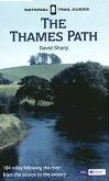
| The walk is also covered in detail in the Thames Path National Trail Guide, by David Sharp, ISBN 1-84513-062-6 published by Aurum Press Ltd. Click on the image to the right to go to the Amazon page for the book.
|  |
Distances
| From | To | Distance (m) | Ascent (ft) | Descent (ft) |
|---|---|---|---|---|
| Shepperton village hall | Hampton Court | 6.8 | 105 | 128 |
| Hampton Court | Richmond | 7.8 | 167 | 174 |
| Richmond | Putney Bridge station | 9.1 | 157 | 164 |
This makes a total distance of 23.7 miles, with 429 feet of ascent and 466 feet of descent.
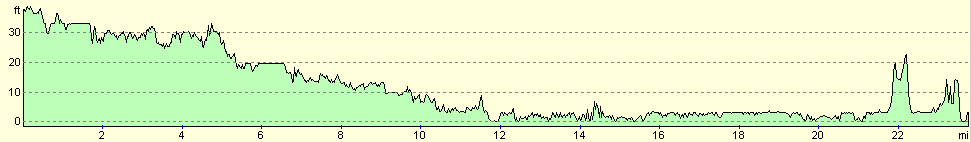
For more information on profiles, ascents and descents, see this page
Transport
Shepperton is served by trains from London Waterloo station, at a cost of £5.90. Putney Bridge is on thw Wimbledon branch of the District tube line, from where the centre of London can be rached. Note that I believe that the Shepperton train can also be caught from Wimbledon, and it will probably be quicker to go south to Wimbledon that it would be to catch the tube to Waterloo to catch it from there.
Disclaimer
Please note that I take no responsibility for anything that may happen when following these directions. If you intend to follow this route, then please use the relevant maps and check the route out before you go out. As always when walking, use common sense and you should be fine.
If you find any information on any of these routes that is inaccurate, or you wish to add anything, then please email me.
All images on this site are © of the author. Any reproduction, retransmissions, or republication of all or part of any document found on this site is expressly prohibited, unless the author has explicitly granted its prior written consent to so reproduce, retransmit, or republish the material. All other rights reserved.
Although this site includes links providing convenient direct access to other Internet sites, I do not endorse, approve, certify or make warranties or representations as to the accuracy of the information on these sites.
And finally, enjoy your walking!
Nearby walks
| # | Title | Walk length (miles) |
|---|---|---|
| 50 | Paddington to Mile End | 8.3 |
| 60 | Slough to Alperton | 16.7 |
| 65 | Alperton to Paddington | 6.4 |
|
|

|