Walk #39: Keld to Baldersdale
 |
 |
|
General Data
| Date Walked | 17/08/1999 |
| County | North Yorkshire, Durham |
| Start Location | Keld YHA |
| End Location | Baldersdale |
| Start time | 07.45 |
| End time | 14.25 |
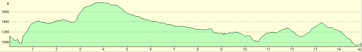
| Distance | 15.0 miles |
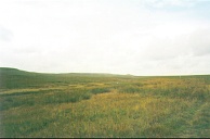
| Description | This was a reasonable walk, although the flat, boggy moorland was a bit of a let-down after the high hills of the last few days. |
| Pack | Today I carried full camping gear. |
| Condition | My back gave me more trouble today, a situation that I can put down to my pack after a lengthy investigation on Sleightholme Moor. My ankle is okay. I was generally very fatigued at the end of the 15 mile walk, which came as a slight surprise. |
| Weather | Today's weather was quite nice. It was generally a sunny with some occasional cloud early on, becoming more overcast later. It tried to rain around lunchtime, but hardly enough to get wet. It started really bucketing it down after I got to the YHA, but of course I missed that. |
| OS map | Outdoor Leisure number 30 (Yorkshire Dales - Northern & Central Areas) and Outdoor Leisure number 31 (North Pennines - Teesdale & Weardale) |
Map of the walk
Maps courtesy of Google Maps. Route for indicative purposes only, and may have been plotted after the walk. Please let me have comments on what you think of this new format. For a detailed table of timings for this walk, please see the table file.
Notes
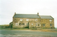
This was not the most spectacular of days, the high point for me (literally!) being the Tan Hill Inn which, due to the early hour, I did not even enter. Sleightholme Moor was a relatively easy slog, and I once more arrived at the YHA early.
The YHA here at Baldersdale is very nice, the welcome superb and the home-cooked food is delicious. It also has a nice atmosphere. Unfortunately the YHA at Langdon Beck is full tomorrow night, and so I have had to book myself into a B&B about 3/4 of a kilometre nearer Middleton.
The situation with my pack is getting plain silly. Not only is it ripped, but I am now sure that it is the main culprit for my back troubles. I will have to see what I can do about this tomorrow.
So how do I feel at what is styled as the halfway point of the Pennine Way? The answer is exhilarated to have even got this far, but nervous about the long days coming up especially the section from Dufton to Garrigill. If I can do that, then the Pennine Way has done its worst to me (longest day, highest point, steepest climb etc). I now feel that I have a 50-50 chance of completing the entire walk, and if I survive the Dufton to Garrigill section in a fit state a 75-25.
I have generally loved the scenery over the course of the walk so far. It has varied from the bogs of Kinder to the Karst landscape of Malham to the lucious greens of Keld, and it has always been on a large scale.
Even if, for some reason, I had to give up on the hike tomorrow, I would have had an extremely nice holiday. It has been strenuous, but I have seen areas of this fine land that I have not before seen, and experienced things that I have not before experienced. I just wish that the weather could have been better. ;*)
This youth hostel is exceptionally nice - the warden is very friendly, and there are lots of home-made biscuits and cakes available to buy. This evening is a classic example of exactly what youth hostelling is about - nice people and friendly chats.
Directions
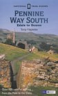
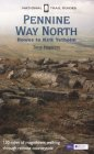
I am not going to bother giving any directions for any of the stages of the Pennine Way; there are many route descriptions produced that will better anything that I could produce. The main guides I used were the OS National Trail Guides, which come complete with strip maps of the route. Click on one of the links below to go to the Amazon page for each guide.
|
| 
|
| |
| |
Distances
| From | To | Distance (m) | Ascent (ft) | Descent (ft) |
|---|---|---|---|---|
| Keld | Tan Hill Inn | 4.4 | 991 | 377 |
| Tan Hill Inn | A66 | 6.5 | 305 | 879 |
| A66 | Blackton YHA | 4.1 | 459 | 646 |
This makes a total distance of 15.0 miles, with 1755 feet of ascent and 1902 feet of descent.
For more information on profiles, ascents and descents, see this page
Disclaimer
Please note that I take no responsibility for anything that may happen when following these directions. If you intend to follow this route, then please use the relevant maps and check the route out before you go out. As always when walking, use common sense and you should be fine.
If you find any information on any of these routes that is inaccurate, or you wish to add anything, then please email me.
All images on this site are © of the author. Any reproduction, retransmissions, or republication of all or part of any document found on this site is expressly prohibited, unless the author has explicitly granted its prior written consent to so reproduce, retransmit, or republish the material. All other rights reserved.
Although this site includes links providing convenient direct access to other Internet sites, I do not endorse, approve, certify or make warranties or representations as to the accuracy of the information on these sites.
And finally, enjoy your walking!
This walk was mentioned in the following routes:
| My sectional Land's End to John O'Groats walk |
| My Pennine Way Walk, 07th to 26th August 1999 |
Nearby walks
| # | Title | Walk length (miles) |
|---|---|---|
| 38 | Hawes to Keld | 12.9 |
|
|

|