Walk #232: Howdon Station to Sunderland Station
 |
 |
|
General Data
| Date Walked | 11/10/2002 |
| County | Tyne and Wear |
| Start Location | Howdon Station |
| End Location | Sunderland Station |
| Start time | 08.33 |
| End time | 14.48 |
| Distance | 15.3 miles |
| Description | This was a nice walk through a mixture of city and countryside, crossing the Tyne and Wear rivers. |
| Pack | Today I carried my 30-litre Karrimor HotRock rucksack, which was filled with my packed lunch, waterproof coat, water bottle and a couple of spare shirts, together with the usual assortment of odds and ends. |
| Condition | I feel fine after this walk, and have no problems that I can really complain about. The string wind made the walk harder than it would otherwise have been, and I am more fatigued for the same reason. Yet again I have no blisters, which I am thankful for. |
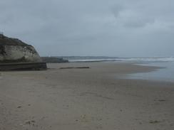
| Weather | Today was a very windy day, as it had been for the last few days. The worst thing was that it was essentially a headwind for the walk south along the cliffs, which meant that I found prgrfess quite had. There were a few showers of rain, and I was thankful that I had several layers on as the combination of both the rain and the wind was highly annoying and chilling. There was little if any sunshine all day, and it was generally far froma nice day to be walking. |
| OS map | Landranger number 88 (Newcastle Upon Tyne, Durham & Sunderland) |
 |
 |
|
 |
 |
|
Map of the walk
Maps courtesy of Google Maps. Route for indicative purposes only, and may have been plotted after the walk. Please let me have comments on what you think of this new format. For a detailed table of timings for this walk, please see the table file.
 |
Notes
As we were staying on at the caravan site in Whitley Bay for another night, I caught a bus to Whitley Bay Station and then the Tyne and Wear Metro to Howdon Station. This meant a long journey before I could even start the walk, and I was quite glad when I finally arrived at the station and do some stretches prior to starting the walk. The area around Howdon was not particularly nice, and I was keen to walk the short distance to the foot tunnel that runs under the River Tyne. I had been tempted to walk further into the centre of Newcastle to cross the river, but the thought of walking many more miles through the city was more than enough to dissuade me. The only downside to this was that I did not get to see the famous cityscape of Newcastle, the bridges; I also did not get to see the new latest addition to the bridges over the Tyne; a new pedestrian bridge that opens and closes like a blinking eye.
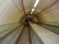
The foot tunnel under the Tyne is entered by a not very attractive entrance building, low and squat with a domed roof that makes it look more like a bomb shelter than an old symbol of civic pride. Once I entered the tunnel I was dismayed to see that the escalators were running as it was rush hour, and I was wondering whether taking an escalator down would means that I had not walked all the way around the coastline. I could not be bothered waiting around for nine when they stop, and so I took the escalator down into the tunnel. The interior of the tunnel was far preferable to the exterior, and it was well lit and looked reasonably nice, with the green and cream tiles giving it a thirties feel. Halfway through the tunnel there is a line of green tiles marking the boundary between Northumberland and Durham, with the names of the counties marked out on the tiles. I enjoyed the walk through the tunnel, and when I got to the southern end I was glad to see that the escalators were not working so that I could walk up them, to emerge blinking into the light at the top.
Some road walking took me to Jarrow, known for many things including shipbuilding and strikes. What it is less well known for, however, is the monastery; the church inside the grounds is very old indeed, as St Paul's Monastery was one of the cradles of Christianity in England, and the Anglo-Saxon scholar Bede (or the venerable Bede, as generations of schoolchildren will know him) lived and worked at the monastery for a long time. I wanted to have a look around the monastery but it was not due to open until later on in the day, and so I continued plodding on along the roads towards Tyne Dock. This involved walking along busy main roads, and I was exceedingly glad when I passed Tyne Dock and I could divert northwards along quieter road to gain access to the seafront in South Shields. Once I had reached the mouth of the Tyne in South Shields, the going became much better and enjoyable as I left the Tyne and started walking along roads and promenades southeastwards past the South Pier and on to the cliffs near Trow Point. On the way, however, I nipped into the Sundancer pub by the promenade for a quick drink; this was much needed, and the twenty-five minute break allowed me to relax, and I had a nice chat to the barmaid about the walk. The pub was nearly deserted, partly as a result of the early hour (it was not yet midday), and the fact that it was out of season.
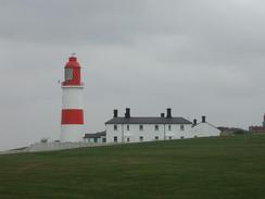
At Trow Point I came across a piece of military archaeology that I had never heard of before; a so-called 'disappearing gun'. This gun faced out to sea, and popped up out of concrete revetments to fire. Apparently the design was not a success, but it was nice to see the restored gun facing out to sea, another sign of the perils that these shores faced in World War Two. This led on to a very enjoyable little stroll as the clifftop path took me on past Frenchman's Bay before eventually meeting the A183 road at the northwestern end of Marsden Bay. The road took me past the Marsden Rock, which lies a short distance offshore from the cliffs. The rock is 130 feet high and 230 feet long and looks fairly spectacular. The cliffs also hide another secret; a lift that goes down from the cliffs to a cave that has been made into a restaurant; an unusual feature that I did not get time to explore. I only had to put up with the road for a short distance, however, before a footpath led along the top of some relatively spectacular cliffs to Lizard Point and the Souter Lighthouse. The lighthouse has a fluorescent red stripe painted around it to make it distinct from the other lighthouse in the area, and it made a fairly stunning sight. The views from near the lighthouse were quite impressive as well, and I enjoyed standing near it and watching the waves come rolling in.
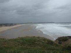
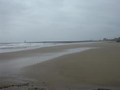
From Lizard Point I continued along the cliffs, and near Souter Point I passed across a rifle range that was fortunately silent; so far on this walk I have not had to change my route due to any firing ranges being active, although I do not know how long that luck will hold. Eventually I could descend down onto the beach at Whitburn Bay, and I enjoyed the short stroll along the sands to the Parson's Rocks, which separate the beach from Roker Beach. The sea was quite rough by the time that I reached Roker Beach, and I got a good view of waves breaking impressively over the north breakwater (called Roker Pier), which protects Sunderland Harbour. A short walks along a cycle path took me along the northern bank of the River Wear to the bridge over the River, which is an elegant arched structure. Unfortunately I could not get a good view of it, as maintenance was being done on it and it was covered up with scaffolding and sheeting. This was a shame, and I felt like one of the archetypal views of Sunderland had been stolen from me. I must admit I had expected Sunderland to be a fairly dark and dank place, but the riverside walk was actually surprisingly refreshing and satisfying.
I was quite keen to finish the walk early, as I was due to meet Sam so that we could do some shopping. For this reason when I reached Sunderland Station I did not stop for a look around but got on a train for the centre of Newcastle, where Sam was waiting for me. The first item on my shopping list was a new GPS, as I had to replace my old one that had gone wrong on the very first day of the trip. Ever since then I had felt almost naked without one, and I was keen to get an updated model. Once I reached Sunderland Station I got the Metro into the centre of Newcastle, and we then went to a couple of walking shops that Sam had found. After looking around them I decided on buying a Garmin ETrex; this is a much more capable model than my old Magellan GPS, and will allow me to download track logs onto my PC if I so desire in the future. I was tempted to go for a more advanced model such as the ETrex Vista, but I really could not justify the cost as I doubted that I would use the extra functionality that it offers on this trip. After visiting a few more shops we caught the bus back to Whitley Bay and the caravan site, where I started to play with my new toy.
Directions
This walk starts off at Howdon Station, on the north bank of the River Tyne to the east of Newcastle. Leave the station and turn right to head south along a road; when this road ends at a T-junction turn left to follow another road for a short distance until it ends at a roundabout. At the roundabout turn to the left and follow it for a short distance until the rotunda that marks the entrance to the Jarrow foot tunnel under the Tyne is reached. Enter the rotunda and cross the Tyne using the tunnel. On the other side turn left and walk along a minor road that passes a car park before ending at the B1297 road. At the road turn left and follow it as it almost immediately turns to the right to head southwards; shortly after this take a minor road that leads off to the left. This road heads in a rough southeasterly direction, passing a church that is the site of the old St Paul's Monastery. This road crosses a tidal stream before ending at the A185 road.
Turn to the left to start following the A185 road as it heads eastwards for a little over a kilometre. At a roundabout turn half-left to follow the road northeastwards; it almost immediately passes under a railway bridge. Continue on over another roundabout, after which there is another one; turn left at this roundabout and follow a minor road northwards as it runs to the east of Tyne Dock. Continue on along this road as it runs slightly inland of the river until it ends at a roundabout with the B1344 road. At the roundabout turn left and follow the B1344 road as it curves around the mouth of the river, before eventually settling on a southeasterly course past the South Pier. The B1344 road ends at a roundabout with the A183 road; continue straight on along the A183 for a short distance and then turn to the left to walk along either the promenade or the beach southeastwards.
Once the beach and promenade ends near Trow Point, join a footpath that climbs up and follows the top of the cliffs southeastwards, passing Frenchman's Bay and curving around to reach Marsden Bay, where the A183 road parallels the coast. You do not need to join the road as a path continues on along the top of the cliffs past the bay. After about a kilometre the road curves away to the right, leaving the path to continue on along the top of the cliffs to Lizard Point and the Souter Lighthouse. The path then continues on southwards to Souter Point, where there is an army firing range; the path here may be closed of firing is going on and a diversion around the range would be needed via footpaths and the A183 road. If the range is open then walk through it and continue southwards past Whitburn and on to the northern end of Whitburn Bay.
Here drop down onto the beach, and follow it southwards to the Parson's Rocks, and then on past a disused lighthouse and onto Roker Beach. Follow this southward past the Roker Pier towards the lifeboat station. At the lifeboat station head inland slightly to join the A183 road, and when this reaches a roundabout continue straight on for a short distance down a minor road. A cycle path then leads off to the right; this passes a lovely marina before joining the north bank of the River Wear and following it as it curves around for over a mile, eventually settling on a westerly course to Wearmouth Bridge over the River Wear. Climb up onto the bridge and turn left to cross the Wear; when the road meets a roundabout on the southern side of the river continue straight on southwards for a few hundred metres through the centre of the city; Sunderland Station is on the right and is well signposted.
Distances
| From | To | Distance (m) | Ascent (ft) | Descent (ft) |
|---|---|---|---|---|
| Howdon Station | South Shields | 5.3 | 207 | 305 |
| South Shields | Sunderland Station | 10.0 | 965 | 869 |
This makes a total distance of 15.3 miles, with 1172 feet of ascent and 1174 feet of descent.
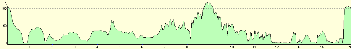
For more information on profiles, ascents and descents, see this page
Transport
I used the Tyne and Wear Metro to get back from Sunderland to Newcastle, where I met Sam to do some shopping. From there we got the bus back to the Whitley Bay caravan park where we were staying.
Accommodation
We stayed at the Whitley Bay Holiday Park, which is just off the A193 road to the north of Whitley Bay. Their full address is Whitley Bay Holiday Park, The Links, Whitley Bay, Tyne and Wear, NE26 4RR, and they have a web presence at www.gbholidays.co.uk. It cost us thirteen pounds to camp here for the night. The same people as last night's ran this campsite, and I have about the same comments - when I called in here at lunchtime to visit Sam the toilets were in an awful state, and although the site is quite neat and tidy I was generally not very impressed.
Disclaimer
Please note that I take no responsibility for anything that may happen when following these directions. If you intend to follow this route, then please use the relevant maps and check the route out before you go out. As always when walking, use common sense and you should be fine.
If you find any information on any of these routes that is inaccurate, or you wish to add anything, then please email me.
All images on this site are © of the author. Any reproduction, retransmissions, or republication of all or part of any document found on this site is expressly prohibited, unless the author has explicitly granted its prior written consent to so reproduce, retransmit, or republish the material. All other rights reserved.
Although this site includes links providing convenient direct access to other Internet sites, I do not endorse, approve, certify or make warranties or representations as to the accuracy of the information on these sites.
And finally, enjoy your walking!
This walk was mentioned in the following routes:
| My walk around the coastline of Britain |
Nearby walks
| # | Title | Walk length (miles) |
|---|---|---|
| 231 | East Sleekburn to Howdon | 18.0 |
| 233 | Sunderland to Blackhall | 15.4 |
| 931 | Hadrian's Wall Path: Chollerford to Newcastle | 26.9 |
|
|

|