Walk #255: Wells-next-the-Sea to Sheringham
 |
 |
|
General Data
| Date Walked | 03/11/2002 |
| County | Norfolk |
| Start Location | Wells-next-the-Sea |
| End Location | Sheringham Station |
| Start time | 07.30 |
| End time | 15.03 |
| Distance | 19.8 miles |
| Description | This was a lovely walk through many varied types of scenery, from sea banks to marshland to beach and cliffs, all wrapped up in some great sea views. It was a thoroughly memorable walk. |
| Pack | Today I carried my 30-litre Karrimor HotRock rucksack, which was filled with my packed lunch, waterproof leggings, water bottle and a couple of spare shirts, together with the usual assortment of odds and ends. |
| Condition | I am fatigued after this walk, and I found it hard to wring the last mile out of my body. After a significant period with no problems, the last couple of days have seen me having little aches and pains which, whilst they are not significant in magnitude, have been annoying. |
| Weather | The weather today was lovely. As I set off from the van in Wells there was scarcely a cloud in the sky, and the sea looked all the more glorious for it. As the day went on it started to cloud over more and more, but there was fortunately no sign of any rain. There was more wind than there has been over the last few days, but not enough to bother me unduly. |
| OS map | Landranger number 132 (North West Norfolk, King's Lynn & Fakenham) and Landranger number 133 (North East Norfolk, Cromer & Wroxham) |
 |
 |
|
 |
 |
|
Map of the walk
Maps courtesy of Google Maps. Route for indicative purposes only, and may have been plotted after the walk. Please let me have comments on what you think of this new format. For a detailed table of timings for this walk, please see the table file.
 |
 |
|
 |
 |
|
Notes
As of today I have walked 600.9 miles on this trip, which I felt to be a cause of celebration, so we got a bottle of wine in Sheringham before going back to the campsite. It feels very strange to have walked this far, but it also feels good in another way - fifty-six of those miles have been added in the last three days, which is a good bit extra than my schedule stated. My schedule for the next few days around the Norfolk coast consist of relatively low daily mileages, and this seems to be because I have walked them before. It will be good to see if I can gain an extra day or two on my schedule over the next week.
When I was walking around the beach near Cley Eye I found another seal on the beach. Slightly fearful after what happened yesterday, I approached this seal slowly so that I could get a photograph of it. Fortunately this one seemed to be in much better health, and before I even got to within twenty yards of it it had shuffled itself into the sea. About half a minute later I saw its eyes and nostrils break the surface, and once more before it came back out onto the beach again about fifty yards away from where it had been. It was nice to see a seal in a relatively good state of health after the ill one I had seen yesterday.
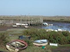
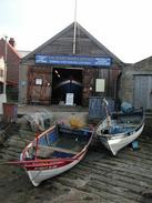
I stopped for a rest and to eat some of my lunch at Muston, where there are some seats overlooking the moored boats. This is a nice spot, and last time I was here there was a sandwich van selling fresh crab sandwiches. Unfortunately it was not prsent today, but this scarcely spoilt the view that I had.
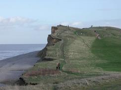
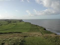
The cliffs which lead from Weybourne Hope to Sheringham are a favourite little spot of mine - for some reason the cragginess of the cliffs really appeal to me. I used a photograph taken on a previous trip of Deadman's Hill as a backdrop on my computer at work for a while, and it was nice to see that the cliffs had hardly changed. These are the first real cliffs that I have encountered since Bridlington, which seems like an eternity ago. This fact alone shows exactly how flat the east coast is. I feel as if I have spent the majority of the last two weeks walking on nothing but sea walls!
On the way up the cliffs I me a couple from Holt who were out on a walk. I chatted to them on the ascent, and it turned out that they were members of the local golf club. At the top of the cliffs near the coast guard lookout post they met some people they knew, and they all gave me a donation towards the charity. This was very nice of them, and we chatted for a few minutes before I made my apologies and started the descent, as I knew that Sam would be waiting for me at the station in Sheringham.
When we got to the campsite in West Runton I was intrigued to see that it was almost directly next to a footpath which I had walked last year when walking to the highest point of Norfolk. The site is in a large cutting in an area of woodland, and it was nce to see that I had already walked in this area.
Directions
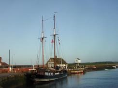
This walk starts off at a campsite that is near the lifeboat station to the north of Wells-next-the-Sea. Leave the campsite and head south until you reach the harbour car park. As this walk mainly follows the North Norfolk Coast Path it is fairly well signposted and the going is easy.
Leave the car park and turn left to follow the B1105 eastwards for a short distance. When the road turns sharply to the right to head southwards away from the sea, continue straight on along a minor road towards the outskirts of the town.
When this road starts to veer to the right, continue on along a well-signposted footpath. This joins some flood banking which continues to the east. When the flood banking starts to veer to the right, follow it and do not attempt to follow the footpath that is marked on the 1:50,000 OS maps as the bridge over the creek is not present. Instead keep to the banking and follow it as after a short distance it turns to the left to head eastwards once more. A gate soon blocks the path at the top of the flood banking, but a footpath descends to the left off the flood banking to join with the footpath off the dilapidated bridge.
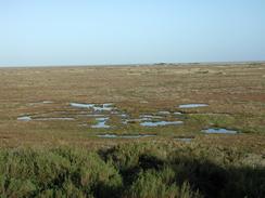
From there the path continues to skirt the southern edge of some wide mudflats, which were empty when I visited but are covered at high tides. It crosses the Warham Greens and proceeds for about three and a half kilometres to the outskirts of Stiffkey.
The path meets end-on with a rough track at a car park in Stiffkey. Continue along this track as it heads eastwards, skirting a creek to the north before meeting end-on with a road coming from the south from the eastern end of Stiffkey village. From here the route follows a footpath that heads for a little over a mile across Stiffkey greens, before it ascends to the top of a little floodbank.
At the eastern end of the flood bank the track descends and turns sharply to the left to head northwards for a little distance. It then turns to the right and follows a track eastwards to the little settlement of Morston. Head for the car park in Morston, where there are some seats available if you want to have a rest.
The path leaves Mortson by following the top of the flood banking eastwards from the car park. At the eastern end of the flood banking the path descends and can be easily followed across to meet the Agar Creek on the outskirts of the village of Blakeney. The path emerges into Blakeney by a little quay on The Quay road. Once past the quays heads for the car park, from where a path leaves to the left to heads northwards along the flood banking. Do not follow the path that heads north slightly to the west on a lower level, as this is a dead end.
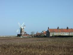
The path on top of the flood banking continues out of Blakeney for about a kilometre before turning to head eastwards to Blakeney Eye. At Blakeney Eye it turns south towards the windmill in Cley-next-the-Sea. All of this section in very easy to navigate along as the path follows the top of the flood bank. The path meets the A149 road and a path takes you down to the bridge over the River Glaven, and soon the village of Cley-next-the-Sea is entered.
Enter the village and walk along the A149 through the village as it turns left and passes the windmill before making a series of small turns to the right. When the junction with a minor road (Beach Road) is reached on the left turn up it and follow it as it heads northwards for a mile to the car park an shingle beach at Cley Eye.
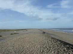
At the car park at Cley Eye climb up to the top of the shingle bank and turn right. Progress in a north-south-easterly direction along the shingle beach which runs between the sea to the left and a nature reserve on the right.
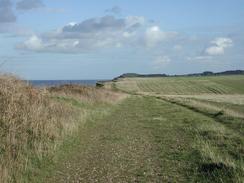
After a few miles the car park at Weybourne Hope becomes visible. Here the walk along the shingle beach ends and the path starts to climb up to the top of the cliffs. Follow the cliffs as they head eastwards from Weybourne Hope, passing just to the southern (inland) side of an old customs house. The path then continues on for another couple of miles, passing a golf course as it ascends to a little hut that is a coastguard lookout post. The path then meets the Esplanade before descending down onto the Promenade in Sheringham.
Continue along the high-level path until it ends, and then descend down some steps to a lower level promenade. Walk eastwards along this promenade past a lifeboat museum. When the path meets a road with the Shannocks Hotel to the right, turn right and head southwards through the town, When a road branches off to the right beside a clock tower continue straight on, and the BR railway station is a short distance ahead on the left, and the car park and North Norfolk Railway station is opposite it on the right had side of the road.
Distances
| From | To | Distance (m) | Ascent (ft) | Descent (ft) |
|---|---|---|---|---|
| Wells-next-the-Sea Campsite | Blakeney | 8.5 | 187 | 180 |
| Blakeney | Weybourne Hope | 7.9 | 220 | 200 |
| Weybourne Hope | Sheringham Station | 3.4 | 381 | 341 |
This makes a total distance of 19.8 miles, with 788 feet of ascent and 721 feet of descent.
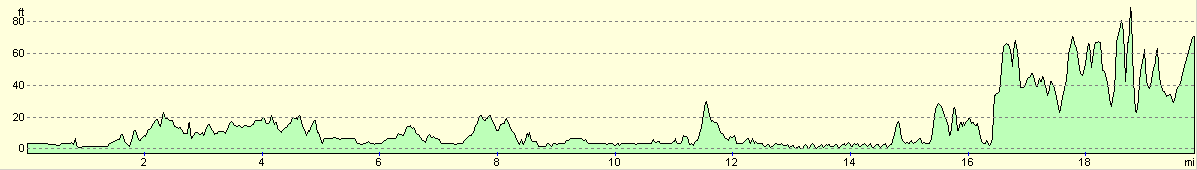
For more information on profiles, ascents and descents, see this page
Accommodation
We stayed at the Camping and Caravanning Club site at West Runton, Holgate Lane, West Runton, Cromer, Norfolk NR27 9NW. They can be contacted on 01263 837544. This is a nice little site that is almost literally in the middle of nowhere, set in a clearing in the middle of trees with an almost unfeasibly long drive needed to get to it.
Disclaimer
Please note that I take no responsibility for anything that may happen when following these directions. If you intend to follow this route, then please use the relevant maps and check the route out before you go out. As always when walking, use common sense and you should be fine.
If you find any information on any of these routes that is inaccurate, or you wish to add anything, then please email me.
All images on this site are © of the author. Any reproduction, retransmissions, or republication of all or part of any document found on this site is expressly prohibited, unless the author has explicitly granted its prior written consent to so reproduce, retransmit, or republish the material. All other rights reserved.
Although this site includes links providing convenient direct access to other Internet sites, I do not endorse, approve, certify or make warranties or representations as to the accuracy of the information on these sites.
And finally, enjoy your walking!
This walk was mentioned in the following routes:
| My walk around the coastline of Britain |
Nearby walks
| # | Title | Walk length (miles) |
|---|---|---|
| 134 | Burnham Deepdale to Wells-Next-The-Sea | 9.5 |
| 160 | Wells-Next-The-Sea to Cley-next-the-Sea | 11.1 |
| 165 | Cley-next-the-Sea to Cromer | 13.1 |
|
|

|