Walk #256: Sheringham to Rudram's Gap
 |
 |
|
General Data
| Date Walked | 04/11/2002 |
| County | Norfolk |
| Start Location | Sheringham Station |
| End Location | Rudram's Gap |
| Start time | 08.00 |
| End time | 14.08 |
| Distance | 15.1 miles |
| Description | This was a relatively short walk following the beach the whole way around the coast eastwards from Sheringham to Cromer and then on southeastwards to Mundesley and beyond. It was a lovely walk, although if the tide is high then you will have to walk over the cliffs instead of along the beach. |
| Pack | Today I carried my 30-litre Karrimor HotRock rucksack, which was filled with my packed lunch, waterproof leggings, water bottle and a couple of spare shirts, together with the usual assortment of odds and ends. |
| Condition | Towards the end of today's walk I started having little aches in both of my ankles. Whilst these were not enough to make me stop the walk early, they were disconcerting and annoying. I also have a little backache, which could be due to my posture when sitting at the computer. Aside from these niggles everything felt fine on this lovely day. |
| Weather | The weather today was lovely, with blue skies for most of the day with only a few threatening grey clouds about. There was no sign of any rain, and there was not much wind to bother me. |
| OS map | Landranger number 133 (North East Norfolk, Cromer & Wroxham) |
 |
 |
|
 |
 |
|
Map of the walk
Maps courtesy of Google Maps. Route for indicative purposes only, and may have been plotted after the walk. Please let me have comments on what you think of this new format. For a detailed table of timings for this walk, please see the table file.
 |
Notes
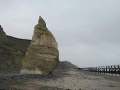
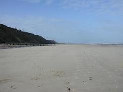
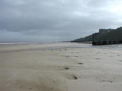
This was a very long walk which was almost entirely along good, sandy beaches. I was very fortunate in that the high tide this morning was at about six, which meant that by the time I had started the walk the tide had receded enough to allow me to walk under the cliffs between Sheringham and Cromer. Some stretches of this beach are not places to get caught out by the tide coming in, and even though I knew it was going out for the majority of the time that I was walking I took care to memorise every place I could climb onto the cliffs in case I did reach a headland that was impassable. By midday the tide was very low, and it was obvious that I would have absolutely no problems by this stage as the tide was so far out that I could walk out and around the end of the groynes.
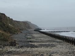
In places (particularly just to the north of Mundesley) the groynes were quite difficult to get past, with one end in the sea and the other end embedded into the cliff. One in particular required a climb of seven or eight feet to get over, which I manages to do after a few seconds though about where the best foot- and hand- holds were. I had exactly the same problem when I last did this walk, and progress would have been much slower if I had had to do this with every groyne.
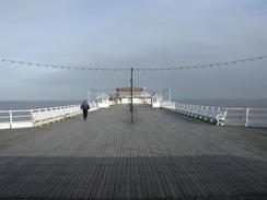
I met Sam in Cromer near the pier so that I could check through my email which my dad had sent to us via the post office poste restante system. There was nothing of any great importance to be dealt with, except for a small cheque that needed paying into my account. Later on we met again at the Ship Inn in Mundesley, as I knew that today was going to be a short day and that I had no need to hurry. I had a pint of Wherry whilst we were there, and when I got towards the bottom of the glass I noticed that there was various detritus (small leaves and other organic matter) floating at the bottom of the glass. I had drunk nearly the whole pint so I could not see much point in complaining, but when we got up to leave I decide to tell the barmaid. Her reply was quite funny: "okay". Not sorry, or any form of apology, but just a fat, okay. It made me wonder if this lack of surprise made it a common occurrence!
Tomorrow I will try to walk down as far as Caister, which is just to the north of Great Yarmouth. This should be about an eighteen-mile day, which I think is just right for how I am feeling. The high tide should be occurring at roughly seven in the morning, which means that the first section to Happisburgh will probably have to be done by walking along the cliff top paths.
Directions
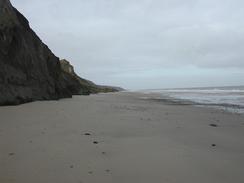
The directions for this walk are very simple if the tide is not high; simply walk down the road from Sheringham Station to the beach, and then turn right. If the tide is high then this route should not be attempted, as it could be very easy to get trapped by the tide; there are other routes available at the top of cliffs in most places. If the tide is low then this is an enjoyable walk with high cliffs present to the right for most of the day that means that escaping from the beach if the tide comes in could be difficult in places.
From the car park by the station in Sheringham turn left and follow the road as it heads northwards towards the seafront, passing a clock tower on the way. When it meets the seafront by the Shannocks Hotel turn right and join the sea wall. Continue walking along the sea wall eastwards out of the town as high cliffs start to rise on the right.
Follow the beach eastwards for about four miles, passing the gaps (places where access to the beach can be made) at West Runton and East Runton. Just before East Runton Gap a little headland is passed and Cromer pier becomes visible in the distance ahead. Continue on into Cromer and climb onto the seawall for the next part of the walk towards the pier.
From the pier continue on along the seawall until it ends. The wall is replaced with some wooden sea defences and groynes. Walk along the beach as it turns to head south-eastwards , passing below Overstrand and Sidestrand before eventually reaching Mundeslsey. There are few if any access points from the beach up onto the top of the cliffs along this stretch, so care is needed not to get trapped by an incoming tide.
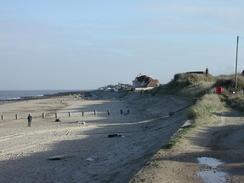
On the outskirts of Mundesley climb up onto the seawall and then turn right up a gap to meet the B1159 road. Turn left along this road, passing a car park on the right, until you reach the Shipp Inn on the left. Just before the Ship In there is a little pathway that leads back down onto the beach. If you do not wish to stop in Mundesley then you can ignore this set of directions and just continue on southeastwards along the beach.
Once on the beach turn right to continue southeastwards, for three miles, passing under the Bacton gas distribution centre (the only part of this visible from the beach are some towers and the fence around the edge of the cliffs). As Bacton Green is approached the cliffs to the right become lower and a sea wall begins. Sam met me about a kilometre further on from Bacton green at a place called Rudram's Gap, where the B1159 road parallels the beach.
Distances
| From | To | Distance (m) | Ascent (ft) | Descent (ft) |
|---|---|---|---|---|
| Sheringham Station | Cromer | 4.3 | 118 | 171 |
| Cromer | Mundesley | 7.0 | 315 | 289 |
| Mundsley | Rudram's Gap | 3.5 | 151 | 187 |
This makes a total distance of 14.8 miles, with 584 feet of ascent and 647 feet of descent.
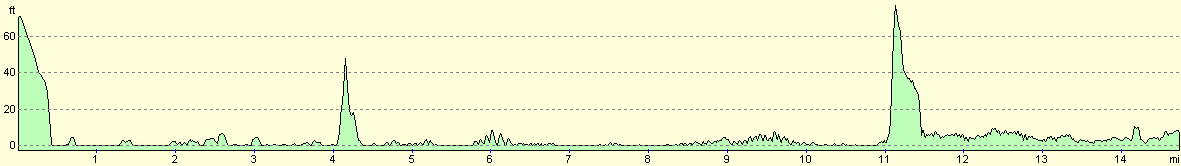
For more information on profiles, ascents and descents, see this page
Accommodation
We stayed at the small site at The Duke of Edinburgh Public House, Coast Road, Bacton, Norfolk NR120EU. They can be contacted on 01692 650280. This site was quite small (it consisted of a few pitches near a pub car park), and the facilities were all in the main part of the pub. Having said that, the shower was hot and powerful, and what facilities there were present were clean and tidy. This is the first of this type of campsite that we have stayed at, and as winter comes along it probably will not be the last. It cost us seven pounds fifty pence for the night.
Disclaimer
Please note that I take no responsibility for anything that may happen when following these directions. If you intend to follow this route, then please use the relevant maps and check the route out before you go out. As always when walking, use common sense and you should be fine.
If you find any information on any of these routes that is inaccurate, or you wish to add anything, then please email me.
All images on this site are © of the author. Any reproduction, retransmissions, or republication of all or part of any document found on this site is expressly prohibited, unless the author has explicitly granted its prior written consent to so reproduce, retransmit, or republish the material. All other rights reserved.
Although this site includes links providing convenient direct access to other Internet sites, I do not endorse, approve, certify or make warranties or representations as to the accuracy of the information on these sites.
And finally, enjoy your walking!
This walk was mentioned in the following routes:
| My walk around the coastline of Britain |
Nearby walks
| # | Title | Walk length (miles) |
|---|---|---|
| 155 | Caister-on-Sea to Sea Palling | 12.5 |
| 163 | Sea Palling to Mundesley | 9.4 |
| 165 | Cley-next-the-Sea to Cromer | 13.1 |
|
|

|