Walk #442: Gretna to Powfoot
 |
 |
|
General Data
| Date Walked | 14/05/2003 |
| County | Cumbria, Dumfries and Galloway |
| Start Location | Gretna |
| End Location | Powfoot |
| Start time | 10.10 |
| End time | 17.34 |
| Distance | 17.9 miles |
| Description | This was quite a strenuous little walk, but one made memorable for the fact that I finished England and re-entered Scotland within a few minutes of setting off. |
| Pack | Today I carried my 30-litre Karrimor HotRock rucksack, which was filled with my packed lunch, waterproof leggings, water bottle and a couple of spare shirts, together with the usual assortment of odds and ends. |
| Condition | I am quite tired after this walk, which is not ver surprising as I was tired when I set off. My legs did not seem to function in the usual way today, and I never really got into the flow. Despite this I had no trouble with either of my ankles, for which I am glad. |
| Weather | Today was quite a sunny day, with only a few clouds in the sky. There was not much wind, and I therefore got quite hot at times. There was no sign of any rain, for which I am thankful. |
| OS map | Landranger number 85 (Carlisle & Solway Firth, Gretna Green) |
 |
 |
|
 |
 |
|
Map of the walk
Maps courtesy of Google Maps. Route for indicative purposes only, and may have been plotted after the walk. Please let me have comments on what you think of this new format. For a detailed table of timings for this walk, please see the table file.
 |
Notes
The day started of quite strangely, with two radio interviews, one with Radio BBC Scotland, where someone came to interview us outside the Gretna Chase Hotel, and a telephone interview with CFM. Sam and I then walked to the bridge over the River Sark, which marks the border, and I had a celebratory glass of whisky to celebrate entering Scotland.
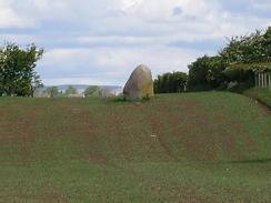
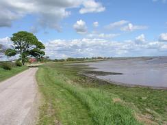
I walked west from Gretna along the side of the estuary, passing the Lochmaben Stone on the way, and eventually running between the large MOD area and the Solway Firth. This MOD area is part of a massive munitions complex built in the First World War when not enough munitions were being made. Apparently before this time Gretna was a small village, but virtually overnight the population grew to 15,000, servicing the plant that ran from Longtown in the east to Eastriggs in the west. This is a massive area, and it is interesting to see that much of it is still in use; I passed a large munitions storage area to the west of Longtown yesterday, and today I passed another one. I suppose that munitions storage requires large areas of land, as you do not want massive amounts of munitions stored together just in case an accident happens, so you spread them about in scattered buildings. This means that if one storage unit goes up, it is les likely to spread to others.
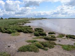
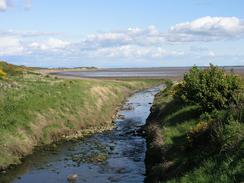
The going along the foreshore was quite difficult, and in places it was alternately marshy, muddy or shingle. There is a track marked on the map running past the MOD area, but for much of the time this is nonexistent on the ground. This was quite tiring, and the lowest moment came when I reached a stream between Dornockbrow and Dornock Cottage. The stream was not very full, but it would be difficult to cross as it was in a deep channel that would be difficult to climb up. Fortunately there were two old railway rails, heavily rusted, spanning the stream. I put my foot on one of the rails to test how firm it was, and then put my other foot on the other rail, which was slightly to one side and below the other one. Satisfied that the whole construction would not slip down into the stream, I started to slowly and carefully cross. Unfortunately when I neared the halfway point the rails were flexing so much that the top rail was descending and trapping my left foot against the bottom rail, so I was forced to walk only on the top rail, which was much harder for me to balance on. I eventually made my way to the other side, and I could turn back to look over the little acrobatic journey I had just made.
It was with some relief that I reached the outskirts of the little town of Annan. I met Sam near to the station, and we walked together into the centre of the town, which has some lovely buildings in it, including a superb clock tower. We went into the Queensberry Arms Hotel so that I could have a rest and a drink, which was much needed. Eventually we left the pub and Sam walked with me to the bridge over the River Annan, where I left her and walked down the western bank of the river.
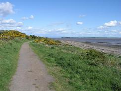
The going on the next stretch of the walk to Powfoot was much easier going than the section to Annan had been, and I enjoyed the walk along the track down to Barnkirk Point and then along the coast. I relaxed and walked relatively slowly, enjoying the views in the sunshine. Eventually I reached Powfoot, and I found Mervan waiting for me outside the Golf Course Hotel.
This evening I went into the bar of the hotel next to which we stayed, and had a quick drink. The bar was quite smoky, and it made my stomach, which was already feeling queasy, do a little jump. When I got back we had a visit from Margaret Barbour, who runs an RDA group in the local area. She is an amazing lady, and we chatted for a couple of hours about life in the local area. During the foot and mouth outbreak in 2001 she placed herself in quarantine with her flock of pedigree sheep for eighty-one days until the crisis was over, eating little else but bread and jam. She kept a diary during that time, and this is apparently being put into a book with other experiences of the crisis. Due to this I went to sleep much later than usual for the fourth night in a row, which means that I shall be very tired in the morning.
Directions
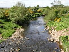
This walk starts off by the Gretna Chase Hotel, on the English side of the River Sark. Leave the hotel and turn right to head northwestwards along the B7076 road, immediately crossing over the river and heading on into Gretna. Immediately adjacent to a little petrol station a road leads off to the left; turn down this road and immediately turn to the left down another road, which heads southwards for a couple of hundred yards before turning to head southwestwards. When the road curves once more to head westwards turn left down a track, which climbs over an old railway embankment and under some power lines, before a path leads over a metal ladder stile to the left, signposted for the Lochmaben Stone. Follow the path around the edge of the marshes, until the mouth of Kirtle Water is reached. Turn right and follow the eastern bank of Kirtle Water northwards; a little way off to the right is the Lochmaben Stone. Continue on along the bank of the river, passing under some power lines and past the abutments of an old railway bridge before a road is met.
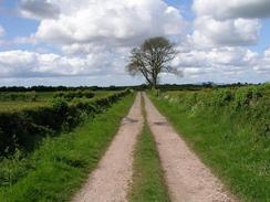
Join the road and turn left to cross Kirtle Water on a bridge, and then continue on for westwards along the road for about half a mile until a road junction is reached on the left. Turn down this road and head south until Redkirk is reached, where a track can be taken to the right. Follow this track westwards; initially it is well surfaced, but it soon becomes a green lane, until it reaches a junction with another track near Bauch. At Bauch turn left to head southwards down a track that leads southwards to meet the side of the Solway Firth.
Turn right and follow a rough track southwestwards along the edge of the marshes. Initially the track is easy to follow, but when it approaches the MOD explosives area at Browhouses it becomes much more indistinct. Continue on southwestwards along the foreshore towards Torduff Point, keeping the high fence of the MOD area to the right. The going becomes increasingly harder as the foreshore comprises shingle, marsh or mud, but eventually you can reach the end of the MOD area at Dornockbrow. Pass the end of the road and continue on across fields towards Dornock Cottages. Unfortunately there is a stream to be crossed, and the only visible means of crossing this is using two old railway rails, which I would not recommend, but I managed it. There may be another route, such as a bridge, further upstream, and an exploration may be useful.
Continue along the coast past Dornock Cottage and Battlehill, before joining he foreshore for a little under a kilometre westwards to Whinnyrig. From here a track led southwestwards for a couple of hundred yards until an old railway embankment is reached, the northern abutment of the old railway bridge over the Solway Firth. Climb up onto the top of the embankment and walk northwards along it, until you reach a little bridge, where you can descend to the left and climb over a fence to reach a flood bank. Follow this flood bank westwards; progress was hard, so when I reached Summergate Lane I followed this northward for a kilometre until the station is reached. Cross over the railway line and head up to the B721 road through the town. Turn left and walk westwards to cross a lovely arched bridge over the river. On the other side turn left and descend down some steps onto a cycle path that heads southwards along the western bank of the River Annan. The path passes under a new footbridge over the river and then a railway bridge, and when it turns to the right away from the river follow it into Newbie.
When a road junction is met in Newbie continue straight on down a track that heads southeastwards past a factory towards Barnkirk Point, where the track curves to the right to head westwards. When the track meets a road at Newbiebarns follow this inland until a crossroads is reached, and then turn left to head southwestwards towards Newbie Mains. Follow the track as it skirts the coastline to Newbie Cottages, and then follow a green lane on along the coast. When this became indistinct I dropped down onto the foreshore, and walked along this until the eastern side of Pow Water is reached. Follow the river upstream for a short distance until a road bridge is reached, and then turn left to cross the river on the bridge. Head straight on along the road into Powfoot, and this road ends on the right at the Powfoot Golf Hotel.
Distances
| From | To | Distance (m) | Ascent (ft) | Descent (ft) |
|---|---|---|---|---|
| Gretna | Annan | 12.6 | 338 | 328 |
| Annan | Powfoot | 5.3 | 381 | 381 |
This makes a total distance of 17.9 miles, with 719 feet of ascent and 709 feet of descent.
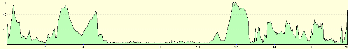
For more information on profiles, ascents and descents, see this page
Accommodation
We parked Mervan on the road outside the Powfoot Golf Hotel, in Powfoot. This was handy for the pub, but there were not many other facilities in the area.
Disclaimer
Please note that I take no responsibility for anything that may happen when following these directions. If you intend to follow this route, then please use the relevant maps and check the route out before you go out. As always when walking, use common sense and you should be fine.
If you find any information on any of these routes that is inaccurate, or you wish to add anything, then please email me.
All images on this site are © of the author. Any reproduction, retransmissions, or republication of all or part of any document found on this site is expressly prohibited, unless the author has explicitly granted its prior written consent to so reproduce, retransmit, or republish the material. All other rights reserved.
Although this site includes links providing convenient direct access to other Internet sites, I do not endorse, approve, certify or make warranties or representations as to the accuracy of the information on these sites.
And finally, enjoy your walking!
This walk was mentioned in the following routes:
| My walk around the coastline of Britain |
Nearby walks
| # | Title | Walk length (miles) |
|---|---|---|
| 438 | Allonby to Angerton | 24.1 |
| 439 | Angerton to Burgh by Sands | 17.3 |
| 440 | Burgh by Sands to Cargo via Carlisle | 17.3 |
|
|

|