Walk #584: Doveridge to Longport
 |
 |
|
General Data
| Date Walked | 30/12/2003 |
| County | Derbyshire, Staffordshire |
| Start Location | Doveridge |
| End Location | Longport |
| Start time | 08.02 |
| End time | 15.30 |
| Distance | 21.7 miles |
| Description | This was a long and fairly undistinguished road and canal towpath walk westwards from my home in Doveridge. |
| Pack | Today I carried my 30-litre Karrimor HotRock rucksack, which was filled with my waterproof leggings, water bottle, trainers and a couple of spare shirts, together with the usual assortment of odds and ends. |
| Condition | I feel absolutely fine after this walk, and I could easily have walked further if there had been more daylight. |
| Weather | The weather today was fairly overcast, with some periods of light snow, and even ten minutes of a heavier snow shower. It did not really go much above freezing all day, but there was little wind to chill me, so all in all it could have been far worse. |
| OS map | Landranger number 128 (Derby & Burton upon Trent), Landranger number 127 (Stafford & Telford, Ironbridge) and Landranger number 118 (Stoke-on-Trent & Macclesfield) |
 |
 |
|
 |
Map of the walk
Maps courtesy of Google Maps. Route for indicative purposes only, and may have been plotted after the walk. Please let me have comments on what you think of this new format. For a detailed table of timings for this walk, please see the table file.
Notes
As of this morning I only had 19.9 miles to complete before doing 5,000 miles this year, and as I only had two days in which to do the distance I felt as though I had better do the distance today. I really did not feel like driving anywhere, and so I planned to do a gentle stroll to Stoke-on-Trent instead, which I estimated would be about the correct distance. I could see from the map that the vast majority of this walk would be along roads and it would not be what could ever be called a classic walk, but at least it would get me into some new terrain.
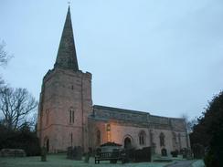
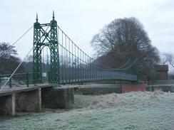
There had been a fairly heavy frost overnight and the temperature was still low as I set off, heading through Doveridge to the church (passing the ancient Yew tree in the churchyard, which is reputedly where Maid Marion and Robin Hood got married), before descending to the lovely suspension bridge over the River Dove. This is a lovely and tranquil spot, the only disturbance being a low rumble from the nearby A50 road. A short stroll along the raised pathway across the floodplain took me to the A50 bridges, and the old Dove Bridge (from which Doveridge got it's name) behind it.
This marked the start of what was a long road walk westwards all the way into the centre of Stoke. The firs thing of any real note was the Checkley, a village I had not been to since I was a teenager. One of the pubs in the village, the New Broom, has as it's sign a brush and a curling stone - a sport I associate more with Scotland than rural Staffordshire! The church in Checkley is also quite nice, although I did not go in for a look around. The road carried on through Lower and Upper Tean, and in the latter I left the main road (which was quiet enough with not much traffic) and took a minor road that headed west. In Totmonslow this passed over the old Cheadle branch railway line; when I looked down onto the line from the bridge over it I was amazed to see that, although the track was still in place and technically the line was disused, trees were growing from the track to above the height of the bridge! The line has obviously not been used for some years, and I doubt that it will ever be used again without the track being re-laid.
In Blythe Bridge I stopped outside the Black Cock pub, intending to go inside for a drink as I was halfway though the walk. As I was standing outside writing my location down in my notebook a man came out gruffly stating that the pub was shut during the day, despite the fact that I was standing by a board stating that it was open all day. I was not too bothered, and I walked on towards Blythe Bridge station. On this stretch it started to snow, and I had the first real snowstorm of the winter - large flakes came raining down, and it even made a fairly dismal place such as Blythe Bridge seem magical. The snow put a spring in my step, and it cheered me up as I approached the conurbation of the five towns of Stoke-on-Trent. On the outskirts of Meir the way became blocked by the A50 dual carriageway running in a cutting and tunnel, but fortunately there were side roads and cycle paths that ran parallel to the A50(T) on the top of the cutting.
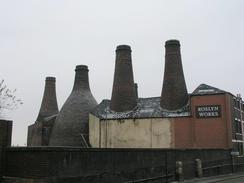
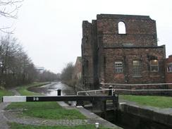
These roads took me through Longton and past a set of old pottery bottle kilns, a once ubiquitous sight in the Potteries but now sadly becoming rarer, to Longton Station, before I eventually reached the station in Stoke-on-Trent. The station was quite architecturally interesting, and I had a quick look around, and I also got a timetable for the Crewe to Derby railway line, which I would have to use later on in the day. As I had not yet completed the necessary 19.9 miles for the day I decided to join the Trent and Mersey canal, and follow this northwestwards to Longport. The initial stretch of the canal walk was fairly grotty, with concrete walls on either side shoring up the local road network. Past the first lock, however, things improved, and although it was a fairly standard inner-city canal towpath walk, at least the concrete walls had disappeared. At Etruria Junction I passed the place where the Caldon canal heads off towards Leek and the Peak District - another canal that I should really walk along sometime.
It was getting late as I passed the disused steelworks at Shelton - the massive buildings had not yet been demolished, but they were silent and deserted - a sad sight. I decided that I would not be able to make Kidsgrove, another couple of miles along the canal, before it got dark, and so I decided to stop the walk at Longport. I went to the station to check on the train times, and then went into the Railway Inn to have a quick pint and while away twenty minutes. I left ten minutes before the train was due, and when it had not arrived half an hour later I phoned up National Rail Enquiries, only to have them tell me that the trains no longer serve the station and I had to take a bus service instead. It said that the next bus would go at 16.50 from the car park by platform two, and yet the information signs at the station stated that there was no car park! There were no notices stating that bus services were running instead of trains, and so I started to get quite annoyed. When the time came I stood on the station footbridge, where I saw a minibus arrive beside Platform one! Fortunately I caught it (saving another hour-long wait), and it deposited me at Kidsgrove, where I could finally get a train back to Uttoxeter. This was an annoying and highly frustrating to a notable day, and I could frankly have done without it. Still, I managed to reach the 5,000-mile target for 2003, which cannot be a bad thing!
Directions
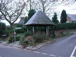
This walk starts off at the lay-by outside the primary school in Doveridge. turn left to head north for a few yards, and then follow the road as it curves to the left by the Methodist chapel. The rpad then heads westwards through Doveridge, passing to the right of the post office / shop. The road ends at a crossroads by the village well; here continue straight on with the well on the left and a pond on the right, up to the church. Here you can either follow the road as it curves steeply downhill to the left, or you can walk through the churchyard past the ancient Yew tree and church instead. Whichever route you take you will emerge at the bottom of the hill, where a path leads off westwards; it soon crosses a metal bridge over an old millstream before reaching a distinctive suspension bridge over the River Dove. Cross the bridge and then continue straight on along a raised embankment that heads northwestwards to meet the A50(T) by Dove Bridge. Once the A50(T) is reached turn left and follow a cycle path that runs along the southern side of the A50(T) for a few hundred yards; when it meets the A518 road cross the A518 and continue on along the cycle path as it passes The Racecourse pub and heads on westwards. It passes under an overbridge and reaches a roundabout with the B5030 road.
Once the roundabout is reached turn right and walk along the B5030 for a few yards before taking an old road that heads off to the left, crossing a small bridge over the River Tean before reaching a proper road. Continue straight along this road as it heads northwards through Spath (also passing the site of the first automatic rail crossing in Britain - sadly the railway has now gone). The road curves to the northwest and enters Stramshall, from where it heads westwards to cross the River Tean once again before ending at the A522 road in Beamhurst. Trunk right and follow the A522 road as it heads in a roughly west-southwesterly direction through Fole, Checkley (where the church is worth a look) and Lower Tean. In Upper Tean the A522 curves sharply to the left; when it heads off to the right continue straight on along a minor road that heads westwards to Totmonslow and Draycott-in-the-Moors. As the road approaches Blythe Bridge it becomes dual carriageway and turns to the left; when it does this turn right to essentially continue straight on northwestwards along the A521 road, past Blythe Bridge Station and onwards until it meets the A50(T).
Pedestrians are understandably banned from walking along the A50(T), and so instead follow side roads and cycle paths that run parallel to it as it heads northwestwards through Meir. In Normacot a junction with the old A50 is reached on the right; turn down it and follow it as it heads northwestwards to a large junction by Longton Station. Continue straight on keeping the station to the left, and follow the road northwestwards into Fenton. Continue across two roundabouts and then onwards for another kilometre to another roundabout. Here turn right to head northwestwards with a railway line to the left. When a road junction is met continue straight on to head northwestwards for a few hundred yards until Stoke-on-Trent railway station is met on the left. Head past the station and at the bottom of the road turn left to pass under the railway line; a few yards further on this road reaches a complex junction making a roundabout; below the middle of this roundabout runs the Trent and Mersey Canal. The towpath runs on the far side of the canal, so after you descend to the side of the canal you have to cross a footbridge to get to the towpath.
Once on the towpath turn to the tight to follow the Trent and Mersey Canal as it heads northwards through Stoke-on-Trent. After about a kilometre Etruria junction with the Caldon Canal is reached; here remain on the Trent and Mersey canal as it heads northwards; after a few hundred yards the towpath switches onto the eastern side of the canal for a short distance before swapping back over to the western bank for the rest of the way. The canal passes right by the Shelton steelworks, the buildings still being extant but the works themselves are sadly and almost eerily silent. Shortly after the Middleport Pottery on the other side of the canal a road overbridge is reached; here turn left and follow the road as it passes between two pubs, before taking Station Road off to the right, which leads southwestwards to Longport Station, where this walk ends.
Distances
| From | To | Distance (m) | Ascent (ft) | Descent (ft) |
|---|---|---|---|---|
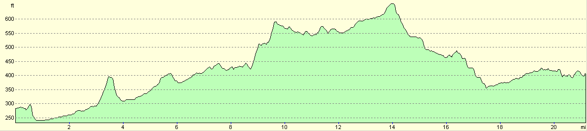
| Doveridge | Checkley | 7.2 | 358 | 220 |
| Checkley | Longton | 8.5 | 459 | 390 |
| Longton | Stoke-on-Trent | 2.3 | 49 | 174 |
| Stoke-on-Trent | Longport | 3.7 | 148 | 102 |
This makes a total distance of 21.7 miles, with 1014 feet of ascent and 886 feet of descent.
For more information on profiles, ascents and descents, see this page
Transport
There would be regular train services between Longport and Uttoxeter, and then bus services run hourly from Uttoxeter bus station back to Doveridge. Unfortunately (see above) train services were not stopping at Longport, and so I had to catch a bus to Kidsgrove and get the train from there, an annoying and frustrating delay.
Disclaimer
Please note that I take no responsibility for anything that may happen when following these directions. If you intend to follow this route, then please use the relevant maps and check the route out before you go out. As always when walking, use common sense and you should be fine.
If you find any information on any of these routes that is inaccurate, or you wish to add anything, then please email me.
All images on this site are © of the author. Any reproduction, retransmissions, or republication of all or part of any document found on this site is expressly prohibited, unless the author has explicitly granted its prior written consent to so reproduce, retransmit, or republish the material. All other rights reserved.
Although this site includes links providing convenient direct access to other Internet sites, I do not endorse, approve, certify or make warranties or representations as to the accuracy of the information on these sites.
And finally, enjoy your walking!
Nearby walks
| # | Title | Walk length (miles) |
|---|---|---|
| 24 | The Weaver Hills | 6.0 |
| 68 | Willington to Doveridge | 12.6 |
| 69 | Doveridge to Thorpe | 14.9 |
|
|

|