Walk #645: Tonbridge to Edenbridge
 |
 |
|
General Data
| Date Walked | 23/01/2005 |
| County | Kent |
| Start Location | Tonbridge Station |
| End Location | Edenbridge Station |
| Start time | 08.00 |
| End time | 14.00 |
| Distance | 17.1 miles |
| Description | This was a nice linear walk following the Eden Valley Walk through Kent. |
| Pack | Today I carried my 70-litre Craghoppers WildPlaces rucksack, with full camping kit minus spare clothes, food and cooking equipment. |
| Condition | I feel absolutely fine after this walk, and I did not suffer from carrying a heavy load for the first time in months. |
| Weather | Today was quite a sunny day. with scarcely a cloud in the sky. It was quite cold, however, particularly when I was exposed to the chilly wind. |
| OS map | Landranger number 188 (Maidstone & The Weald, Royal Tunbridge Wells) and Landranger number 187 (Dorking, Reigate & Crawley area) |
 |
 |
|
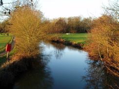 |
Map of the walk
Maps courtesy of Google Maps. Route for indicative purposes only, and may have been plotted after the walk. Please let me have comments on what you think of this new format. For a detailed table of timings for this walk, please see the table file.
Notes
I was well aware that it had been some time since I had last done a walk in Kent, and so I dug out an old printout of a walk that I planned last year in Kent, and found myself driving down the M11 and around the M25 in the dark. It did not take me as long as I was expecting to reach the start of the walk in Tonbridge, and I was relieved to find that the car park near to the railway station was free on Sundays. Because I am starting training for a long, tough walk in May, I had decided to carry my large rucksack with basic camping equipment in. Although this was not full weight (as I chose not to carry spare clothing or food) it was still appreciably heavier than the packs that I had been carrying recently.
The centre of Tonbridge was deserted as I walked along the main road through the town, and the only people about were a couple of workmen beside the road. One of them commented that I was well kitted up, and I ended up chatting to them for a couple of minutes about the walking that I do - they seemed quite interested, and it was nice to be able to chat to someone. I soon reached the site of Tonbridge Castle, and this was shining beautifully in the early morning sunshine. It was here that navigation became slightly difficult - I had to join the Eden Valley walk, and it was not clear on the ground which way it went, I walked in a rough westerly direction beside the river, passed some toilets and crossed a stream before walking beside some playing fields. Eventually I reached the railway line to the west of the town, and here I managed to join the proper route.
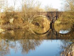
A muddy path took me on through some patchy, scrubby woodland, with the river flowing away on the left. The path soon crossed over to the other bank, and dived under a railway line before skirting a flood barrier and reaching a soaring, dramatic bridge that carries the dual carriageway over the river. Here I saw the first proper signposts for the Eden Valley Walk, as it headed along the edge of a lake and squeezed between the river and another lake. This was a highly enjoyable stretch of the walk, and there were many people out walking their dogs. I felt slightly out of place with my heavy rucksack on, and I managed to overtake most of the walkers as the path headed westwards through a band of trees. Here the way markers went slightly awry as they pointed away from the obvious path through the trees and into a field to the left; I followed them into the field, but it soon became obvious that they were taking me south towards the farm at Ensfield. I left the path and paralleled the trees westwards until I reached a road, where I met the Way once more.
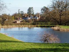
Here the Way crossed a bridge over the river and headed along the northern bank of the river for a short distance before climbing uphill to meet a track by the farm at Killick's Bank. The track led southwestwards towards Well Place Farm, which it bypassed and I joined a footpath that led down a field with some glorious views towards the outstanding views of the buildings of Penshurst Place in the distance. I soon found myself passing these buildings, although a high wall prevented me from getting a very good view of them, and I soon reached the village of Penshurst itself, which was a picturesque little village with an attractive church.
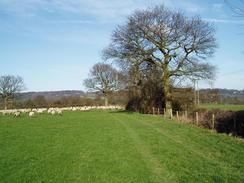
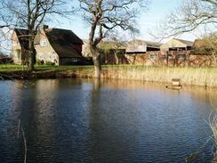
Leaving the village I took a track that headed westwards, crossing the river once more before climbing uphill and reaching a road. A path led me on towards Hill Hoath, and on along some very muddy tracks westwards to Hever. This was another picturesque place, and the path passed right by the church before depositing me on the road near the pub. A little road walking took me on to a bridge over a railway line near Hever Station, and a path led on across some fairly undistinguished fields to Lydens Farm, where there was a strange, ruinous building consisting of three circular rooms. The River Eden was crossed for the last time immediately to the north of Delaware Farm, and a footpath took me on across some nice fields towards Edenbridge. The initial parts of the town that I passed through were not very attractive, but one I reached the church and the centre of the town it improved dramatically. Once I reached the centre of the town I left the Eden Valley Walk and instead walked along roads northwestwards out of the town, passing under a railway line at Spitals Cross before taking a footpath the crossed a railway line in a cutting.
I had plenty of time before the next train, so instead of heading straight for the station I decided to divert off uphill to visit a trig point that is on a hillside to the north of the town. A footpath took me from the farm at Hilders straight past the trig pillar, but I soon found that it was buried deep between two hedges, and I could only just get a photograph of it from the footpath. Immediately to the north the footpath joined a road, and I joined this before going into the next field to see if I could get a better look at the pillar. From this side I got a better view, but it was still not possible to make out the flush bracket number. Disappointed, I rejoined he road and followed it down Marlpit Hill to Edenbridge Station, where I had a short wait for the next train back. It was not a classic walk but enjoyable nonetheless, and it was nice to know I could carry substantially more weight than I was used to with few problems.
Directions
This walk starts off at the railway station in the centre of Tonbridge. Leave the station and turn left to start heading northwards along the B2260 High Street; just before the castle is reached on the left turn left down New Wharf Road and join the Eden Valley Walk, which this route will follow for most of the day. Initially finding the waymarked path on the western side of Tonbridge is difficult as the path head northwestwards along the bank of a stream past playing fields before cutting westwards to reach a railway line embankment. The path passes under the railway line and heads into an area of rough scrubby trees; the path then becomes easier to follow as it meets the northern bank of the River Eden. Follow the rivers southwestwards until just before a flood barrier is reached; the path crosses the river on a bridge and then heads under another railway embankment before turning to the right to head westwards alongside a large flood bank.
When a grassy clearing is reached climb the flood bank and descend the other, western, side to head under a large viaduct carrying a dual carriageway overhead. Once the edge of a lake is reached on the other side turn right to follow the eastern edge of the lake northwards and then turn left to follow the northern edge westwards. The path than skirts the southern edge of another lake and is well signposted as it joins the southern bank of the river for an enjoyable woodland stretch to a road. At the road turn right to cross the river via a bridge and once on the other side turn left. Initially the path follows the northern bank of the river southwestwards before heading of to the right to climb a bank and reach a farm at Killick's Bank. Here turn left to join a track that heads southwestwards; when it junks to the left towards Well Place Farm continue straight on along a footpath that descends down a field to the southwest before reaching a road.
Turn right and follow this road as it heads westwards and then southwestwards as it skirts past Penshurst Place before ending at the A2176 road in Penshurst. Continue straight on as the road curves to the right past the church to head northwestwards, before turning left down a track. This track winds around but takes a rough westerly coruse in doing so, crossing the river on a bridge before ascendng the hill on the other side. It passes a farm at Wat Stock where it joins a track that soon ends at a road. Here a path continues on northwards, slowly curving to head northwestwards towards the end of a road at Hill Hoath. Turn right along this road for a few yards before tuning left, to take another footpath that head roughly westwards through patches of woodland; it joins a track north of Lockskinners Farm that eventually ends at a road by Hever Church. Join the road and follow it as it heads westwards for a few hundred yards before ending at a T-junction.
At the junction continue straight on along a footpath that heads southwestwards for about half a kilometre before ending end-on with another road that heads down to a crossroads. At the crossroads continue straight on to a bridge over a railway line; here turn right to follow a footpath that skirts the top of the cutting northwestwards before diverting off to the left to head westwards across fields towards Lydens Farm. Pass the farm and join a road; turn right along this road for a hundred yards before turning to the left to join a footpath that heads northwards across a filed, passing under a railway line and then continuing on to a road. Turn right along this road for a few yards and then turn left up a track that passes Delaware Farm before crossing the river once more. The path continues northwards for another hundred yards before turning to the left to take a more westerly course, heading to the south of Skinners Farm before joining another footpath that heads southwestwards.
This footpath crosses a railway line and, once on the other side, becomes a track that leads up to meet a road. Follow this road as it passes a graveyard and Edenbridge Church until the B2026 road is reached. Here the Eden Valley Walk is left for the day. To follow my route turn right and head north along the B2026 through the centre of the town until Stangrove Road is reached on the left; turn left and follow this road as it heads westwards before curving to the right to head northwestwards, passing under a railway bridge and continuing on to a sharp left-hand bend. At the bend take a footpath off to the right that heads northwards for a few yards across a field to the southern edge of a high railway cutting, Take the steps down into the cutting, carefully cross the railway line and then climb up the steps on the other side. Cross another short field and exit out onto a minor road.
Turn left to follow this road westwards for about fifty yards until Hilders Farm is reached on the right. Turn right along a track that heads up the middle of the farm; when the track ends continue uphill along a footpath that eventually levels out before reaching a road. Turn right and follow this road eastwards for a few hundred yards until it ends at the B2026 road. Once there, turn right and started following the B2026 road southwards as it heads downhill through Marlpit Hill; when the road passes under a rail bridge turn right to head up to Edenbridge railway station, where this walk ends.
Distances
| From | To | Distance (m) | Ascent (ft) | Descent (ft) |
|---|---|---|---|---|
| Tonbridge Station | Penshurst | 5.7 | 207 | 187 |
| Penshurst | Edenbridge Station | 11.1 | 738 | 673 |
This makes a total distance of 16.8 miles, with 945 feet of ascent and 860 feet of descent.
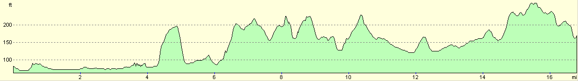
For more information on profiles, ascents and descents, see this page
Transport
There are regular train services between Edenbridge to Tonbridge, which run hourly on Sundays. The journey takes a quarter of an hour, and costs about three pounds fifty pence.
Disclaimer
Please note that I take no responsibility for anything that may happen when following these directions. If you intend to follow this route, then please use the relevant maps and check the route out before you go out. As always when walking, use common sense and you should be fine.
If you find any information on any of these routes that is inaccurate, or you wish to add anything, then please email me.
All images on this site are © of the author. Any reproduction, retransmissions, or republication of all or part of any document found on this site is expressly prohibited, unless the author has explicitly granted its prior written consent to so reproduce, retransmit, or republish the material. All other rights reserved.
Although this site includes links providing convenient direct access to other Internet sites, I do not endorse, approve, certify or make warranties or representations as to the accuracy of the information on these sites.
And finally, enjoy your walking!
Nearby walks
| # | Title | Walk length (miles) |
|---|---|---|
| 591 | Maidstone to Tonbridge | 15.7 |
| 601 | A circular walk along the North Downs from Whyteleafe | 21.6 |
|
|

|