Walk #818: Cosham to Nutbourne
 |
 |
|
General Data
| Date Walked | 09/06/2008 |
| County | Hampshire, West Sussex |
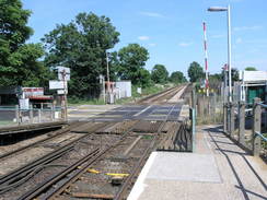
| Start Location | Cosham station |
| End Location | Nutbourne station |
| Start time | 07.08 |
| End time | 15.05 |
| Distance | 20.5 miles |
| Description | This was a pleasant walk, following the easternmost nine miles of the Wayfarer's Walk, and then the coast around Thorney Island. |
| Pack | Today I carried my 30-litre Karrimor rucksack, filled with waterproofs, a book and other odds and ends. |
| Condition | I was very hot after this walk, but after a little rest I could easily have walked further. |
| Weather | Today was an exceptionally hot day, about 27 degrees. There was hazy cloud overhead, but this did not seem to reduce the temperature at all. There was not much of a breeze. |
| OS map | Landranger number 196 (The Solent & The Isle of Wight, Southampton & Portsmouth) and Landranger number 197 (Chichester & The South Downs, Bognor Regis & Arundel) |
 |
 |
|
 |
 |
|
Map of the walk
Maps courtesy of Google Maps. Route for indicative purposes only, and may have been plotted after the walk. Please let me have comments on what you think of this new format. For a detailed table of timings for this walk, please see the table file.
 |
 |
|
 |
 |
|
Notes
Over the last few months I had walked most of the Wayfarer's Walk, and I wanted to finish off the last, southernmost stretch. Fro this reason I found myself driving east along the M27 towards Cosham station, situated to the north of Cosham. The car park there was nearly empty, with only a couple of other cars and a road-rail digger for company. I had to buy a parking ticket at the ticket office as there was not ticket machine, but soon I was heading northwards through the town.
Cosham was fairly quiet at seven in the morning, and there were no shops open in which I could purchase any food. Some people were starting to set out market stalls, but I walked on and joined the A3 for the long walk uphill. I had been expecting this to be a steep climb onto Ports Down, but it turned out to be a surprisingly easy walk, perhaps because the main road angles up the steep slope.
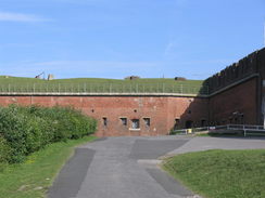
Once at the top I turned left along a road to meet the point I had left the Wayfarer's Walk on my previous trip, then started heading east along the road. There were occasional good views south over Portsmouth and Langstone Harbour, and soon I was passing Fort Purbrook. My map showed the path passing immediately to the north of the fort, but I reached the eastern edge of it before I saw another Wayfarers Walk sign - I had walked to far.
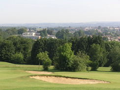
Instead of heading back up the road I turned around and followed the path around the edge of the fort in the wrong direction. You get a good view of the front of the fort before joining a long path that skirts around the edges; the views of the red-brick walls of the fort itself are fragmentary, but there are some pleasant views over the golf course to the north. Eventually the path settles to head westwards behind houses, before rejoining the road. There was a Wayfarer's Walk sign here that I had missed when I had walked past.
I walked back down the road eastwards, enjoying the occasional good views to the south as I passed the entrance to Farlington Redoubt and crossed the M3 on a high bridge. Once past this I was in Bedhampton, and I continued on for about half a mile until the Wayfarer's Walk turned off to the right to head south. Just before this I nipped into a newsagents to buy some food - the nice girl serving behind the counter fond it hard to believe that I had already walked five miles today.
I had walked the next stretch of the trail on several different occasions, and I headed south along a narrow footpath before entering some recreation grounds and a church. I put myself on autopilot as the path followed a railway line and then headed southeastwards towards the A27(T). Despite having walked along here on three different occasions, this was the first time that I actually followed the correct route, which for a short distance skirts the base of the embankment of the A27(T) before crossing over into Brockhampton.
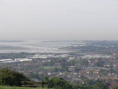
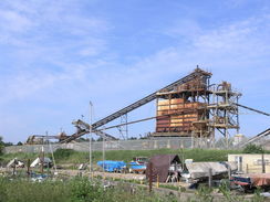
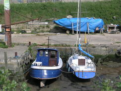
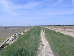
A stream took me south from Brockhampton, slowly getting wider until large expanses of tidal mudflats were visible. Boats were moored on the mud, with the rather inauspicious backdrop of a gravel and sand stockyard, the large, rusting machinery stretching high into the sky. This industrial view changed the moment a bend was curved, and suddenly I was walking along the shoreline of the northern edge of Langstone harbour. The tide was out, but the large expanses of mudflats did not detract from the view. It felt good to be walking beside the sea once more.
On the way to Langstone there was a place where the seawall carrying the path had been eroded away, causing the path to be diverted by a couple of feet. The tide was so far out that it was hard to believe that large enough waves could reach here to cause such damage. The I was in Langstone, and I diverted off the Wayfarer's Walk for a short distance to go down to the car park by the bridge - a far better route than the official one. I headed along the foreshore in Langstone, rejoining the official route and following it up to Warblington churchyard.
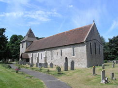
Warblington is a pleasant spot, with the remains of the castle sticking finger-like into the air to the north. I went into the church for a quick look around - on the three previous occasions that I have walked past it I have never been inside. It was nice inside, and another advantage was that it was cool, the temperatures increasing as the day progressed. From Warblington the path took me along Church Path, which followed field boundaries away from the shoreline, passing through an area of scrub woodland.
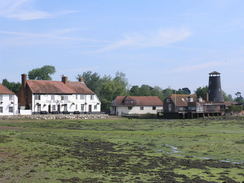
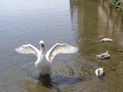
The shore was rejoined on the western extremity of Emsworth, and followed through the town to the tidal pond. There were plenty of swans and other bird life around to look at, and there were also plenty of people about enjoying the sunshine. The area around the tidal pond is very picturesque, and I walked around it until I reached an ice-cream shop. I nipped in, bought myself a large ice cream, and discovered that this part of the tidal pond marked the end of the Wayfarer's Walk. The ice cream felt like a suitable way to celebrate.
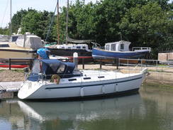
I followed the foreshore around to the marina in Emsworth, but there did not seem to be a way up there, so I walked along roads inland towards the A259, then headed back southwards towards the marina. This was fairly large and quite busy, and, as is often the case, I revelled in studying all the contraptions that lay about, including the huge machines that are used to lift boats out of the water.
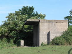
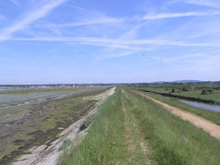
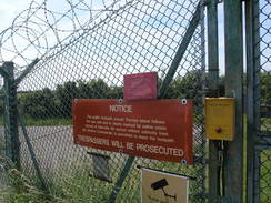
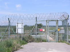
After the marina I joined the Sussex Border Path and followed it around Thorney Island. Initially this headed dead-straight down towards Wickor Point, but immediately after passing the lake called the Great Deep I reached a large gate. Thorney Island was once an RAF base, but although the airfield has closed down the base is still in use by the military. The path runs around the outside, and to get in you have to give them your name, address, contact phone number and a number of other pieces of information. Once they have that information, the gate opens and you can walk through.
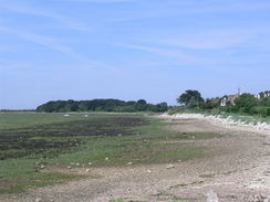
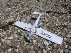
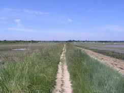
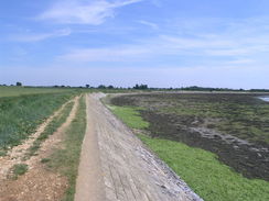
The path around the island is very well waymarked, but basically all you have to do is keep just inland of the foreshore. The path passed Marker Point, and shortly after this I decided to drop down to walk along the rocky foreshore as a change from the banking. About halfway along I came across an odd object on the beach - a large radio-controlled airplane, sans part of the tail, but with a petrol engine that still turned if I moved the propeller. I guess that someone lost control of it and it crashed into the sea, before being washed up here.
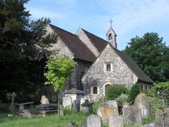
After this I rejoined the path and followed it as it passed the old marker lights for the main runway of the RAF base, and then headed up along paths that had recently been strimmed to reach the village of Thorney. The church in Thorney is a surprisingly large structure, quite long with a small, squat tower that barely reaches above the main roof line.
By this stage I was very hot and was slowly running out of my supply of water. Instead of hanging about I walked on reaching the Great Deep and the gate that led out of the base. When I had walked around the island previously, just before Christmas 2002, the guards had not been able to open the gate, and some young squaddies had had to come out by Land Rover to give it some tender loving before it would open. This time I pressed the buzzer on the intercom and no-one answered. I waited around for well over five minutes before eventually they answered and buzzed me through the gate. It feels like this is the only army base in Britain where they are keen to let you on, but not to let you leave!
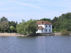
The path led north to Prinsted Point, then on to a large marina, crossing channels leading to the inland berths on rickety bridges. A short distance on was the end of a road in Prinsted; there were some benches here and I sat down for a few minutes, but it was so hot that I decided to stroll on. It was a simple stroll eastwards along the flood banks towards Chidham. I had planned to walk around the little peninsular on which Chidham sits, but the heat had been getting to me. Instead I left the coast as it started to turn southwards, and headed eastwards along a track towards a lane.
From there a road took me northwards, and I phoned Sencan to get the train times from Nutbourne station. I had some time to spare, so I nipped into the Barleycorn pub, positioned right beside the A259. I got two pints of orange and lemonade and sat down slowly letting myself cool down as I drank. I spent about half an hour there before eventually getting up and heading the short distance to Nutbourne station, the sun still beating down onto my head. The journey back to Cosham was simple; I had to change once, but at no time did anyone come along to convert my permit-to-ride to a proper ticket.
It had been a good day's walk, and given the temperature I was very glad that I chose not to extend it. It also cemented the fact that I love the coast.
 |
 |
|
 |
 |
|
Directions
This walk starts off at Cosham station. Leave the station and turn right to head north along the High Street. Continue straight on northwards, following it as it becomes pedestrianised. At the other end of this stretch it becomes London Road; this soon crosses Havant Road and ends at the A3. Turn right and start following the A3 uphill northeastwards for a little over half a mile. When a slip road leads off to the left, follow it and then turn left to join the B2177 road westwards for fifty yards until a junction with the Wayfarer's Walk is reached on the right.
Turn around and start following the B2177 eastwards. Almost immediately it crosses the A3(T) on a bridge, and after a quarter of a mile a footpath leads off to the left, just before a junction on the right with a road from Drayton. Turn left along this path as it heads northwards before almost immediately turning to the right to head eastwards behind some houses. The path approaches Fort Purbrook, and then turns left to walk right the way around the outside of the fort. Once the access driveway is reached on the eastern side of the fort, turn left and walk down it until it ends at a junction with the B2177.
Turn left to start heading east along the B2177 for 1.4 miles; it crosses the A3(M) on a bridge and then enters Bedhampton. When a complex road junction between the B2177, B2149 and B2150 is reached at SU703066, turn right directly opposite the junction and take a footpath that heads southwards. This soon enters a recreation ground; continue on past a building and then angle right, to walk diagonally across a car park to reach Bidbury Lane. Cross the lane, and on the other side start walking southwards along Mill Lane.
This lane rises up to cross over a railway line on a bridge; on the southern side of the bridge turn right to join a footpath that heads down under the bridge before running northeastwards alongside the railway line. When a track is reached on the right follow it, and when it almost immediately ends at a gate, turn left down a footpath that runs along with a stream on the right. When a bridge across a stream is reached on the right, cross it and then cross two stiles to enter an area of meadowland.
Cross the meadowland southeastwards, keeping a set of power lines immediately to the left, and when this ends at a road in an industrial estate cross the road and continue on along a footpath. This squeezes past a car park before turning to the left to run eastwards along the foot of the embankment of the A27(T), before turning to the left once more. This leads shortly to some steps that leads up to a road. Turn right along this road and follow it southwards as it crosses the A27(T) on a bridge and reaches a roundabout.
Here turn right for a short distance, and then immediately after crossing over a stream turn left to follow a footpath southwestwards. Soon a bridge over the stream is reached; cross this, and follow the southern bank of the stream onwards. The stream becomes a tidal creek, and the path opens out. Continue walking along the footpath around the seawall. Near Langstone it dives in along a creek; at the top of this turn right to cross a footbridge and walk eastwards along a driveway past an old mill on the left. Shortly after some houses on the right the road curves to the left; here continue straight on along a path that leads out onto the A3023.
Turn right and follow the B3023 southwards for a short distance until a car park is reached on the left. Enter the car park, and walk past the Inn before following the path around the foreshore. Near a large, black columnar building the path diverts on the inland side, before rejoining the foreshore. Continue on around the foreshore until a metal clapper-gate is reached on the left. Go through this, and walk diagonally across a field to reach Warblington churchyard. Walk through the churchyards towards the church, and then take a path that heads off eastwards immediately to the south of the church.
This path, called the Church Path, heads eastwards for a little over a mile, entering and leaving an area of woodland before joining the foreshore near Emsworth. Continue on along the coast to the tidal Mill Pond, and follow the wall into the centre of Emsworth, where the Wayfarer's Walk ends. Here turn right and drop down onto the foreshore to walk eastwards towards the marina.
When the way ahead is blocked climb up and follow King Street northwestwards towards the centre of the town. Take the first road off to the right, Queen Street, and follow this until it ends at the A259. Follow the A259 eastwards for a short distance, and then take a footpath that leads off to the right, following Slipper road southwards to a marina. Enter the marina and then at the end of the water turn right to gain access to the seawall. At the seawall turn left, and start following the path south along the western side of Thorney Island.
The way will be blocked by a gate; press the buzzer and tell them what they want to know and you should be let in. Follow the path as it heads for five miles around the coast, sticking closely to the marked path. At all times it stays close to the coast, except for a high-water diversion that runs slightly inland in West Thorney.
When another gate is reached after five miles, exit through it and head on up the coast, passing Prinsted Point on the way. The path passes immediately in front of a marina, crossing an entrance on a small footbridge, and the path curves around to reach the end of a road in Prinsted. Here turn right to continue along the coast eastwards for a little over a mile until a footpath junction is reached near SU780048.
Turn left along this footpath, and follow it as it immediately curves to the left. When a track is met after a short distance turn right to follow it eastwards for 0.4 miles until Cot Lane is reached. Turn left to follow this lane northwards; when it ends at the A259 road cross the road and continue northwards along another road for a short distance until Nutbourne station is reached on the left.
 |
 |
|
 |
 |
|
Distances
| From | To | Distance (m) | Ascent (ft) | Descent (ft) |
|---|---|---|---|---|
| Cosham station | B2177 | 1.2 | 269 | 0 |
| B2177 | Langstone | 6.8 | 223 | 502 |
| Langstone | Emsworth | 2.5 | 36 | 36 |
| Emsworth | Prinsted | 7.9 | 131 | 131 |
| Prinsted | Nutbourne station | 2.1 | 23 | 10 |
This makes a total distance of 20.5 miles, with 682 feet of ascent and 679 feet of descent.
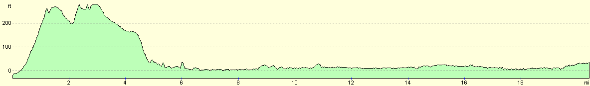
For more information on profiles, ascents and descents, see this page
Transport
There are regular train services between Nutbourne and Cosham; however, few are direct. Where you change depends on which service you get, but a common one appears to be Havant. See the Network Rail website for more information.
 |
 |
|
 |
 |
|
 |
 |
|
Disclaimer
Please note that I take no responsibility for anything that may happen when following these directions. If you intend to follow this route, then please use the relevant maps and check the route out before you go out. As always when walking, use common sense and you should be fine.
If you find any information on any of these routes that is inaccurate, or you wish to add anything, then please email me.
All images on this site are © of the author. Any reproduction, retransmissions, or republication of all or part of any document found on this site is expressly prohibited, unless the author has explicitly granted its prior written consent to so reproduce, retransmit, or republish the material. All other rights reserved.
Although this site includes links providing convenient direct access to other Internet sites, I do not endorse, approve, certify or make warranties or representations as to the accuracy of the information on these sites.
And finally, enjoy your walking!
Nearby walks
| # | Title | Walk length (miles) |
|---|---|---|
| 301 | Pagham to West Itchenor | 19.4 |
| 302 | West Itchenor to Chidham | 14.9 |
| 303 | Chidham to Langstone | 16.0 |
|
|

|