Walk #861: Bognor Regis to Lancing
 |
 |
|
General Data
| Date Walked | 07/07/2010 |
| County | West Sussex |
| Start Location | Bognor Regis car park |
| End Location | Lancing station |
| Start time | 09.07 |
| End time | 15.28 |
| Distance | 18.2 miles |
| Description | This was a pleasant and easy walk following the south coast eastwards. |
| Pack | Today I carried my 30-litre Karrimor rucksack, filled with water, my waterproofs, a couple of books and other odds and ends. |
| Condition | I feel absolutely fine after this walk. |
| Weather | The day was a mixture of sunshine and cloud; there was enough of the former for my arms to get slight sunburn despite the liberal application of suntan lotion. |
| OS map | Landranger number 197 (Chichester & The South Downs, Bognor Regis & Arundel) and Landranger number 198 (Brighton & Lewes, Haywards Heath) |
 |
 |
|
Map of the walk
Maps courtesy of Google Maps. Route for indicative purposes only, and may have been plotted after the walk. Please let me have comments on what you think of this new format. For a detailed table of timings for this walk, please see the table file.
 |
 |
|
Notes
It had been some time since I had last done a walk, and I wanted to get a quick one done. Last weekend we visited the Festival of Speed at Goodwood near Chichester, and it reminded me of this stretch of coast. Last year I walked a stretch up to Bognor Regis, so it seemed sensible to walk the next stretch eastwards. I set off later than expected, and pulled up at a car park near the railway station just before nine. The car park ticket was a quite reasonable price for the day, so I got my kit together and walked the short distance to the seafront.
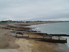
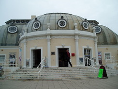
Bognor Regis had not changed much in the previous year, except for the somewhat unusual exercise machines on the promenade to do push-ups and the like on the promenade. It was far too energetic for me, especially as I still had a long way to walk today. I passed the Butlins camp and continued on until the promenade ended near Middleton-on-Sea. The beach here was shingle, but it was ruined by the stench of what looked like tons of seaweed that the sea had thrown up. It was hardly the first flotsam to be washed ashore here; in January 2008, 2,000 tons of wood got washed off the Ice Prince. I think the smell from the timber would have been preferable!
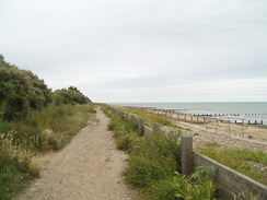
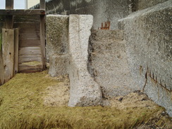
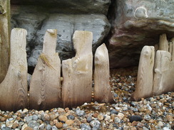
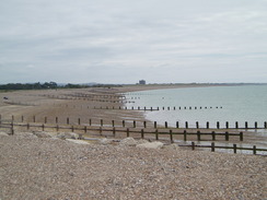
A path continued behind the beach for a short while, and when it ended I had to go down and walk along the shingle. This is always hard walking, and I was soon weaving around in a vain attempt to find the firmest shingle to walk over. To make matters worse, there were frequent groynes that needed to be negotiated. Fortunately some kind-hearted engineer had built concrete steps by the sea wall to help people over; unfortunately these had been eroded by the shingle so that some were almost smooth. It was a salutary lesson about the power of the sea. It was fairly easy to negotiate these steps with care, but they will only get worse with time.
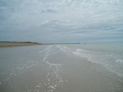
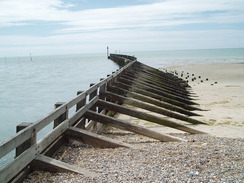
On the eastern side of the town I found a path at the back of the shingle beach, although in places this was still hard going. This took me on past Atherington, and from there I varied walking through the surf on the beach or the top of the banking. Eventually sand dunes unexpectedly appeared on my left as a large wooden pier stretched out to sea to the right.
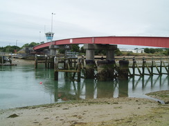
This marked the mouth of the River Arun, on the other side of which was Littlehampton. A road took me from the car park up the western bank of the river to a footbridge over the river. This was built in the 1980s to replace an earlier swing bridge, which itself replaced a chain ferry. A strange pit on the western bank of the bridge shows where it slides to allow yachts to pass under.
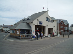
Littlehampton lies on the other side of the bridge, and I followed the river south, passing the lifeboat station on the way. There was an unusual and welcome detail on the way; a series of fish recipes etched into polished stone. I took a few photographs of them, and may try to make one or two in the future. An amusement park appeared on the left before I reached the river mouth once again; it had been a diversion of about a mile and a half just to go a hundred yards across the river.
The beach area of Littlehampton was buzzing as I headed east along the promenade. I passed an area that was barricaded off, behind which was a large metal structure. This turns out to be a long bench that was under construction. A road joined to the left as I went through Rustington, and when this dived off inland a footpath continued onwards towards Kingston Gorse and Ferring. Parts of this path were along a green area that squeezed between grand houses on the left and the shingle on the right; many of the houses were hidden behind high walls and hedges that must have blocked any sea views from the downstairs windows. It seemed rather pointless to spend a fortune on houses this near the sea to then block out the views!
A good path took me onwards towards Worthing, with a nearby road curving sinuously, sometimes being near the path and beach and at others being some distance away. I had parked here a few weeks before to take a short stroll along the beach, and it felt somewhat different approaching it on foot rather than by car - better, as though I had thoroughly earned the view.
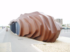
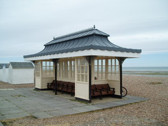
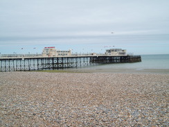
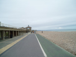
Too soon, the promenade in Worthing began and I passed a series of beach shelters that were both elegant and well-maintained, a combination that is unfortunately all too rare. I resisted the temptation to sit down and instead strode on, the pier growing larger in front of me. The promenade was wide and made for easy walking, something I was fairly glad of by this time. Worthing Pier was grand, a good example of its kind. The front fabric looked as though it could do with a paint, but the pier itself seemed to be in a fair condition.
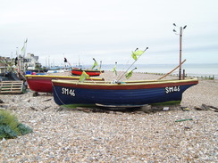
Small boats were hauled up onto the shingle a little further on, a slightly incongruous sight against the backdrop of large buildings. Soon the A259 was accompanying me as I strode eastwards, and the promenade became the road's pavement. I had wanted to go as far as Shoreham today, but that was still three miles away and I decided to cut the day short. There was a station at Lancing, and so I headed through a rather decrepit area of town towards it - all run-down or closed shops. I had a few minutes to wait for my train, so I nipped into the Asda next door to get a bottle of orange juice. As I sat down and waited for my train, I looked back on what had been a very enjoyable day's stroll by the sea. It had hardly been classic scenery, and had been as flat as a pancake, but neither of these factors had spoilt the day.
 |
 |
|
Directions
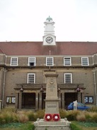
This walk starts off at the Lyon Street car park in Bognor Regis, which is just to the southeast of the railway station. Leave the car park and turn right to head down Lyon Street towards the sea. Pass the Town Hall on the right and continue on along another road until it ends at The Esplanade is reached. Carefully cross the road and join the Esplanade. Turn left to start following the Esplanade eastwards out of the town. The rest of the route never strays far from the sea, following either the beach or paths and roads alongside it.
When the promenade ends, a footpath continues behind the shingle beach until Middleton Point, SZ975 998. If the tide is high you will need to go inland and find road routes; otherwise, drop down onto the shingle beach and follow it eastwards fort about a mile. A path starts behind the shingle beach at SU991 001;follow this eastwards for a mile and a half, passing the car park at Atherington on the way. The footpath joins a track; when this curves to the left to head inland, join the beach and follow it eastwards until the West Pier is reached in Littlehampton.
Turn left and leave the beach, keeping the river on the right. Join a road that heads northwards, passing a car park. After three-quarters of a mile the road curves to the left at TQ021020; here turn right and cross the footbridge over the River Arun (note that the footbridge opens on average twice a day). On the other side of the bridge turn right and start following a road southeastwards; when a large circular sculpture is reached on the right, turn right and head along to the riverside promenade. Turn left to start heading southwards with the river on the right; the promenade passes the lifeboat station and a fairground on the left.
Just before the East Pier is reached turn left and start following the promenade eastwards. It parallels the B2140 for a mile; when this turns away to the left a track continues on eastwards through Rustington and West Kingston. The footpath ends at TQ069014; continue on along the shingle bank for half a mile, after which another path starts behind the shingle bank. Continue eastwards along this path for three miles as it passes through Ferring and Goring-by-sea and reaches West Worthing.
Continue on as the path becomes a promenade through West Worthing to reach Worthing itself. Pass the pier and continue onwards; when the promenade ends join the pavement beside the A259 road and follow it eastwards.
Leave the A259 in South Lancing by turning left up the A2025 South Street. Follow this road as it heads northwards; pass a couple of churches on the left and then turn left up the B2222 road. This immediately curves to the right and Lancing Station is a short distance ahead. Trains back to Bognor Regis leave from the platform on the south side of the level crossing.
 |
 |
|
Distances
| From | To | Distance (m) | Ascent (ft) | Descent (ft) |
|---|---|---|---|---|
| Bognor Regis | Littlehampton | 7.2 | 52 | 66 |
| Littlehampton | Lancing station | 11.0 | 62 | 52 |
This makes a total distance of 18.2 miles, with 14 feet of ascent and 118 feet of descent.
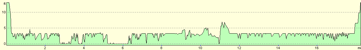
For more information on profiles, ascents and descents, see this page
Transport
Regular trains run between Lancing and Bognor Regis; you have to change at Barnham for the Bognor Regis branch line.
 |
 |
|
 |
 |
|
 |
 |
|
 |
 |
|
 |
 |
|
 |
 |
|
 |
 |
|
Disclaimer
Please note that I take no responsibility for anything that may happen when following these directions. If you intend to follow this route, then please use the relevant maps and check the route out before you go out. As always when walking, use common sense and you should be fine.
If you find any information on any of these routes that is inaccurate, or you wish to add anything, then please email me.
All images on this site are © of the author. Any reproduction, retransmissions, or republication of all or part of any document found on this site is expressly prohibited, unless the author has explicitly granted its prior written consent to so reproduce, retransmit, or republish the material. All other rights reserved.
Although this site includes links providing convenient direct access to other Internet sites, I do not endorse, approve, certify or make warranties or representations as to the accuracy of the information on these sites.
And finally, enjoy your walking!
Nearby walks
| # | Title | Walk length (miles) |
|---|---|---|
| 299 | Peacehaven to Worthing via Brighton | 20.5 |
| 300 | Worthing to Pagham | 18.7 |
| 301 | Pagham to West Itchenor | 19.4 |
|
|

|