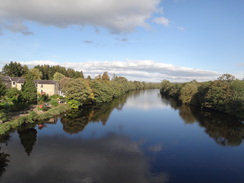
Walk #930: Hadrian's Wall Path: Greenhead to Chollerford
 |
 |
|
General Data
| Date Walked | 25/09/2011 |
| County | Cumbria, Northumberland |
| Start Location | Greenhead |
| End Location | Chollerford |
| Start time | 07.13 |
| End time | 15.48 |
| Distance | 20.2 miles |
| Description | This walk is perhaps one of the most spectacular stretches of any of the national trails. Great views, magnificent terrain and ancient history sit cheek-by-jowl. This walk passes the most spectacular stretches of Hadrian's Wall, and the only problem is that it does not give time to visit any opf the museums. It may well be worth splitting this day into two to allow time to explore more of the Roman sites. |
| Pack | Today I carried my 30-litre Karrimor rucksack, filled with water, my waterproofs, a book and other odds and ends. |
| Condition | This was a fairly strenuous walk, but I have no problems to report after it. The undersides of my feet, which have been aching over the last few walks, were fine today. |
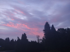
| Weather | Today generally bright day with some cloud; there was no sign of any rain, although there was a fierce breeze at times. |
| OS map | Landranger number 86 (Haltwhistle & Brampton, Bewcastle & Alston) and Landranger number 87 (Hexham & Haltwhistle) |
 |
 |
|
Map of the walk
Maps courtesy of Google Maps. Route for indicative purposes only, and may have been plotted after the walk. Please let me have comments on what you think of this new format. For a detailed table of timings for this walk, please see the table file.
 |
 |
|
Notes
Wow, what a day! I had done much of this walk before whilst doing the Pennine Way, but the memories did not do justice to the scenery, history or simple magnificence of the trail. I set off early, trying not to awaken the four snoring and well-lubricated Irishmen in the room. I also took time to ensure that today, unlike yesterday, I had everything with me. I faffed around at my car for a while as I got my boots and gaiters on, but soon was heading up the road to the point that I had left the trail yesterday.
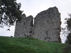
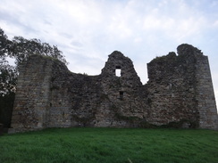
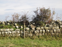
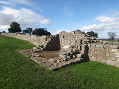
After crossing the railway line and a stream Thirlwall Castle came into view, and here I made a silly mistake, continuing up the hill rather than crossing a footbridge. The mistake at least allowed me to take more photos of the castle. A long and sometimes steep climb followed, during which grand views unfolded to the west along the terrain that I had crossed at the end of yesterday's walk. The trail joined a road and entered a car park at the site of an old quarry where I saw the first walker of the day - a woman and her dog.
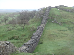
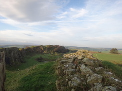
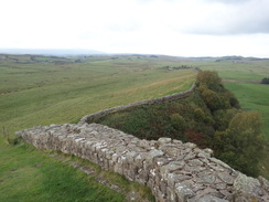
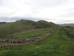
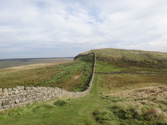
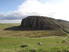
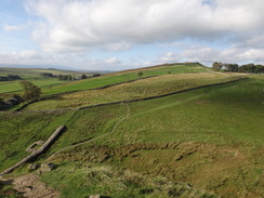
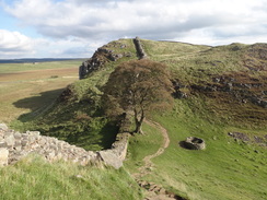
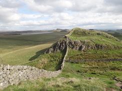
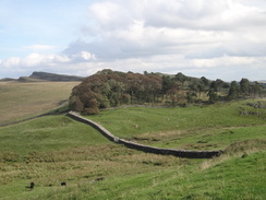
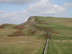
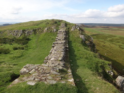
Immediately afterwards another climb took me higher and gave me my first sight of the wall today. What followed was a superb walk along the very edge of the crag as the wall rose and fell, sticking to the very edge of the precipice. It was not easy going but the views, even at this early hour, were superb. Unfortunately it made for slow going, and soon I was down at just 2.3 MPH, far less than the 2.9 MPH I needed in order to get the bus I wanted. Instead of pushing myself on I walked and let the views sink in.
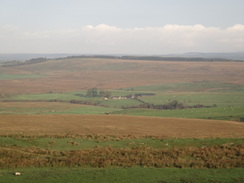
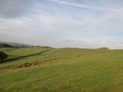
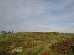
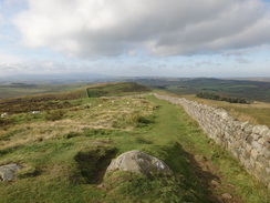
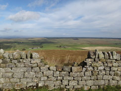
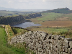
The trail passed a couple of houses that must have great views, even if they are rather remote, then headed down to another old quarry that was overlooked by a half-excavated sharp-pinnacled hill. More climbing followed along this, the most famous stretch of the wall, and slowly and surely more people started to appear. Whereas almost everyone I met further west had been walking the trail, through-walkers were now a rarity and most people were out enjoying the scenery for the day. And who could blame them, for the views across to Kielder Forest in the north and across Northumberland to the south were absolutely superb.
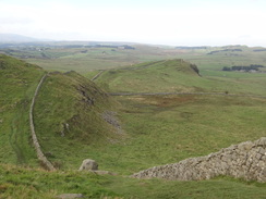
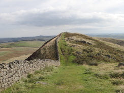
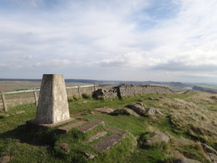
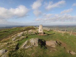
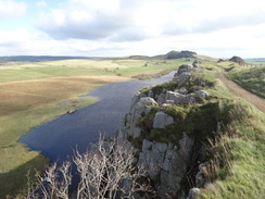
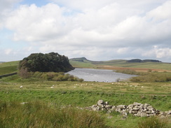
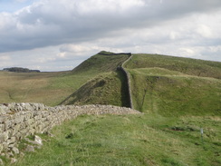
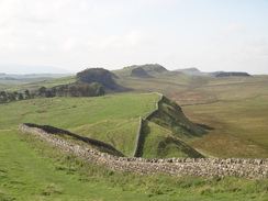
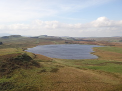
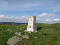
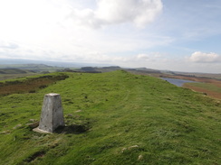
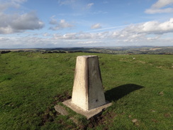
The trail led me up to the trig pillar on Windshield Crags, which I remembered fondly from my stroll along the Pennine Way. Grand views unfold in every direction as you reach the pillar, but it was a little too windy to hang around for too long. Instead I followed the trail as it descended to meet a road. More fevered ascents and descents followed, all rewarding me with great views and history that I could literally reach out and touch. The trail passed the blue water of Crag Lough far below and crossed Hotbank Crags before descending to a gap where the Pennine Way headed off to the north.
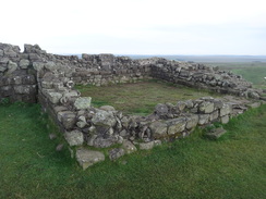
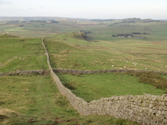
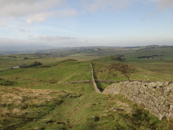
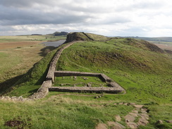
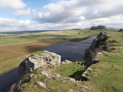
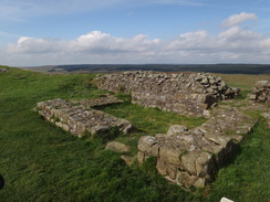
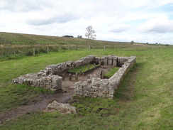
For the first time in the day I was in virgin territory, and what territory it was. The trail passed the famous Housesteads museum (on the site of the Vercovicium roman fort) and then climbed and fell with Broonlee Lough off to the west. It was heavenly, if somewhat slow, walking. It passed Sewingshield Crags and then started to settle down, becoming levelling off as it started to parallel the B6138 road. This would have been boring after the sheer joy of the high crags, had it not been for the remnants of the wall and ditch that frequently came into view.
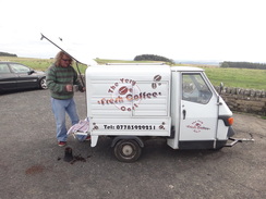
The trail diverted off to visit a sacred well before heading back towards a car park, where a little three-wheeled van was selling coffee. I had a hot chocolate and rather lovely flapjack which quickly disappeared as I continued walking.
The bus came past when I was at least an hour away from Chollerford. Ordinarily I would have been disappointed by this, but not even this inconvenience could put a damper on my mood. It was a glorious day and I was feeling as high as a kite.
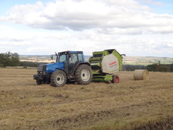
I caught up with a group of kids doing Duke of Edinburgh's bronze award near Milecastle 30, and another at a trig pillar a little further on. A chat ensued in which, for some strange reason, we started talking about CVs. One lad asked me if sending a CV in on yellow paper would make it more distinctive! The answer was yes, but perhaps not the correct sort of distinctiveness... It was a good conversation, but soon I left them behind and strolled on. I was feeling fine, buoyant in fact, and watched as a tractor and bailer disgorged large round bales of hay. Soon I was on the road and passing Chesters, which is now a museum.
There was a bus stop beside the road, but as there was still half an hour before the bus was due it seemed sensible to continue down the hill into Chollerford. I got there in plenty of time, assisted by the downhill slope, but the bus stop was not visible. After walking over the bridge to no avail I headed into the cafe, who told me that it was unmarked on the slip road from the garage. I waited there with not a little trepidation before the bus came, and the driver was kind enough to drop me off at the end of the road that led down into Greenhead, saving me a walk.
This was by far the best day's walk that I had done for some time, although it may better if it were shorter, to allow time to explore some of the sights along the route. In the end I constrained myself rather too much into walking on and on, a mistake that will have to be rectified by revisiting the area in the future. All in all it was a stellar day.
 |
 |
|
Directions
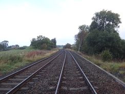
This walk starts off at the Greenhead Hotel. Leave the hotel and turn left to follow the road up a slight slope which soon passes over the railway line. A road junction is reached immediately after the bridge, turn right down the B6318 road and follow it as it parallels the railway line on the right; the pavement soon ends and you are forced onto the road. However there is not much traffic and the road is safe enough. After a third of a mile, a row of red-brick cottages is reached on the right.
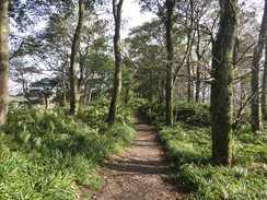
Pass the cottages and then turn right through a metal gate. Pass the cottages on the right; at the end of the cottages go through a wooden clapper gate and then carefully cross the railway line. On the other side go through another clapper gate and descend to a footbridge over a stream. Ignore a cycle bridge on the right and instead go through a wooden pedestrian gate. The path continues on with a stream on the right and a fence on the left, and soon Thirlwall Castle becomes visible on a bluff to the right. Go through another wooden pedestrian gate and then immediately turn sharply right to pass some houses on the left to reach a footbridge over the stream.
Continue up a track that soon curves to the left with a wall on the right; keep the wall on the right as it curves around. Near the top of the hill go through a wooden gate and continue on with a ditch on the right, the first obvious sign of the Wall complex today. Some grand vistas unfold behind towards Gilshead, making the climb worthwhile. At the top of the field climb a ladder-stile and continue on along another field, still with the ditch on the right.
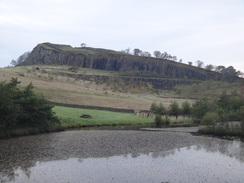
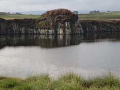
The gradient slackens slightly and some stone slabs lead to a wooden clappergate; go through this onto a road. Turn right to head south down this road for 150 yards and then turn left through the entrance into Walltown Quarry (do not take the entrance a little further on, which carries the Pennine Way). Immediately turn to the left and take a path that heads out of the northern corner of the car park (do not pass the public conveniences).
A path curves to the right past a little mound on the right before settling on a northeasterly course uphill; it goes through a kissing gate and then a wall on the right to reach the crags at the top of the quarry. Alternatively, another pleasant walk can be made past the lake (part of the remains of the old quarry).
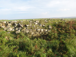
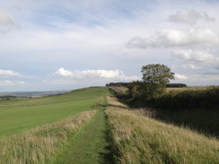
What follows is a wonderful stroll with Hadrian's Wall running along the top of the crags to the left; the wall dips and rises in rhythm with the escarpment and care is needed in places. The path is not necessarily obvious on the ground, but navigation is easy: just keep the wall (and if that is missing the escarpment) to the left as it heads across Walltown Crags. After three-quarters of a mile it descends steeply to reach Walltown Gap in the escarpment at NY680665.
Cross a ladder stile over a wall and climb steeply uphill, still keeping the edge of the escarpment to the left. The path soon reaches a dramatic summit near Turret 44B and then starts slowly falling. It crosses a ladder-stile over a stone wall to enter a band of woodland on Cockmount Hill; the path follows a wide gap through the trees. The path curves to the right when it reaches the end of the trees. Keep a field wall on the left and the trees on the right until it reaches a ladder-stile over the wall.
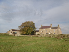
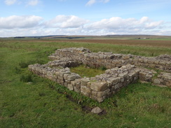
Cross this and on the other side follow the path as it passes immediately to the south of a cottage that must have superb views in all directions. Keep a field wall on the left as you cross small fields; ladder-stiles take you over the field walls. This leads onto a farm called Chesters, which is partly built on site of the old Aesica Roman Fort. Pass a barn on the left and aim for a ladder-stile in a field wall. Cross this and continue on with a field wall a short distance to the left. It crosses a couple more ladder-stiles as it crosses the small fields and starts to head slightly downhill. 2.25 miles after leaving Walltown Gap, the path passes Burnhead Cottage on the left before reaching a stone stile ahead; cross this to reach a surfaced road at NY711665.
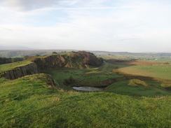
Turn right and follow the road as it crosses the Haltwhistle Burn on a bridge and then immediately turn left down a surfaced track that leads towards Cawfields car park. After a short distance turn right into the car park, and then left to keep the northern edge of the car park on the left. At the end of the car park continue straight on along a path that skirts a lake on the right (the remains of Cawfields Quarry).
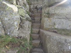
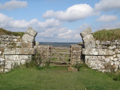
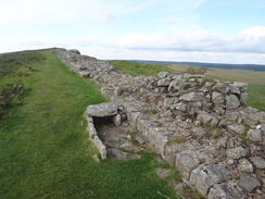
Follow the path as it passes the eastern end of the lake; go through a clapper gate and follow an obvious path that curves half-right uphill to reach a wooden clappergate through Hadrian's Wall. On the other side turn left and follow Hadrian's Wall as it starts to climb, immediately passing the site of the well-preserved Milecastle 42. Continue climbing past Cawfield Crags with the wall to the left and cross any stiles that you come across; a mile after the car park at Burnhead the path reaches a wooden clapper gate. Go through this to reach the road in Caw Gap at NY727668.
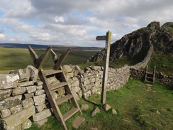
Cross the road, and on the other side go through another clappergate. Climb some stone steps to reach the wall on the left, and continue following this along as it rises and falls. The gradient slackens slightly as it continues climbing with the wall on the left, passing through a series of gates on the way. A little over a mile after leaving Caw Gap, the trig pillar on Windshield Crags is reached. Pass the trig pillar and continue following the wall for another half mile. It descends to a gate and continues with a low stone wall on the left. Cross a stone stile with a field gate on the left, and head towards a clump of trees on the left. Go through a wooden gate to reach a road at Steel Rigg at NY750675. It climbs a stone stile to reach the road, with a car park a short distance to the north.
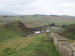
Turn left for a few yards along the road, and then turn right through another clappergate and continue on, this time with a stretch of turf-topped Clayton Wall on the right. The path continues to a gate in a field wall before curving to the right and falling rapidly down steps into Peel Gap. It climbs up steps on the other side onto Peel and Highshield Crags, starting what is perhaps the hardest stretch of the trail so far.
On the other side climb steeply uphill to a ladder-stile and then turn left, keeping the Wall to the left. The gradient levels off before the path descends down stone steps to reach a ladder-stile over a stone wall. On the other side it climbs once again as the Wall disappears. All too soon it descends once more down stone steps towards Milecastle 39 before climbing once more. It reaches a summit and then descends down steep steps into Sycamore Gap.
At the bottom turn left to cross the wall and then turn right to head steeply uphill. At the top cross a ladder-stile and continue with the wall on the right. The path passes high above Crag Lough, which lies down a steep slope to the left. It passes through an area of trees, still with the Wall on the right. It starts to descend some steps to reach a ladder-stile over a wall to leave the woodland. At the bottom, cross a ladder-stile and then turn left across a track and go through a gate in the stone wall.
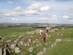
Continue up some stone steps and follow the path as it curves to the left towards Hotbank Farm on the left, and then turn right, joining a line of stone slabs. At the top go through a wooden clapper gate and continue climbing with the Wall on the left. It descends steeply down steps to a ladder-stile over a wall and then slowly descends into Rapishaw Gap, where the Pennine Way leads off to the left. The path generally falls (with a few short, steep ascents as well) across Housesteads Crags, eventually passing Milecastle 37. Keep the Wall on the left; go through a gate in a field wall to enter some woodland and approach the walls of Housesteads Fort. Descend down some steps on the left and walk on, with the wall on the right.
At the northeastern corner of the fort, the trail drop sharply down into a little valley. At the bottom it crosses the Knag Burn and turns right, crossing a wooden gate in the Wall. On the other side turn left to start following the Wall uphill. After a short distance it crosses a stone-stile to enter a small band of woodland. Continue on uphill and leave the woodland via a ladder stile, then head on with Hadrian's Wall on the left. It descends into and climbs out of a couple of gaps, going through some gates on the way; it climbs up Clew Hill and then King's Hill before descending steeply into a valley at NY798694.
Another steep climb northwards reaches a trig pillar at the top of Sewingshields Crags, before curving to take a more easterly course as it slowly descends past Turret 35A and then Milecastle 35. A pedestrian gate in a stone wall leads into Sewings Shields Wood; the path descends through the trees, passing Sewing Shields Farm on the right. It emerges out of the woodland through a similar gate and continues along grass, keeping a couple of cottages to the left. Cross a track beside the cottages and head on; the path passes Turret 34A on the left and then immediately goes through a gate and head towards a clump of trees.
Keep a walled enclosure of trees on the left, and follow the obvious path as it curves slightly to the left. The Wall on the left becomes little more than a triangular mound before finally disappearing. It joins the Wall Ditch on the left and crosses a ladder-stile. 1.5 miles after leaving the trig pillar on Sewingshields Crags, it approaches the B6318 road at NY822705.
Sadly the road has mostly obliterated the Wall in this area, and the trail instead follows the Wall's ditch. The road itself becomes an ever-present fact until Heddon-on-the-Wall, many miles away. At NY848710 the path diverts to the left to avoid the house at Carraw, then turns right across a ladder-stile over a field wall to head eastwards across some stone flags, with a wall and trees on the right. Follow the wall as it curves to the right to rejoin the ditch on the far side of Carraw.
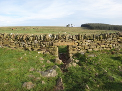
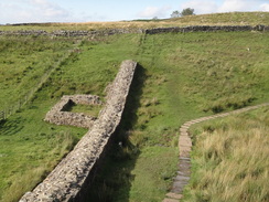
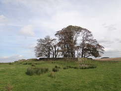
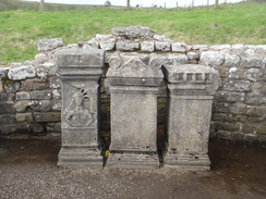
Continue on alongside the ditch for another third of a mile until a track is reached at NY855712. Cross a ladder-stile over a field wall onto the track and then turn right to reach the main road. Carefully cross this, and on the other side cross another ladder-stile. The trail curves half-left and crosses a boggy area on flagstones to reach a stile. Cross this to reach a ladder-stile that leads to Coventina's Well, a well-reserved Roman shrine. Pass the shrine and turn left to join a fence on the left; this soon turns to the left to head towards a car park at NY859712.
Do not enter the car park, and instead turn right to head eastwards uphill for another quarter of a mile. Just before a stone field wall is reached ahead, turn left across a stone stile to reach the main road. Carefully cross the road and on the other side turn left for a few yards to a track; turn right up this track and then turn right across a stile into a field. The path continues on beside the ditch; it crosses ladder-stiles over field walls before reaching a stile in a fence at NY872715.
Here the path starts to curve away from the road to the end of the ditch amongst a spectacular pile of boulders called Limestone Corner. Pick a route past the boulders, either along the bottom of the abortive ditch or immediately to the south; the path slowly curves to the right, crossing a ladder-stile over a stone wall before reaching a trig. Continue on downhill with the road on the right; some patches of Wall become visible on the left. After a third of a mile it crosses a stone stile to reach a surfaced lane at NY883713.
Cross the lane and another stone stile to enter a field, initially with a stretch of Wall and Turret 29A on the left. The wall sadly soon ends and the path continues on across the field to reach a clappergate. Go through this, cross a small farm access driveway and then another clappergate to enter a field. Continue on for another third of a mile with a wall on the right, passing the site of Milecastle 29 (now little more than bumps in a field) until an area of woodland is approached. Here the path curves to the left, keeping the woodland on the right. It goes through a pedestrian gate and crosses a stile as it runs with a fence on the left; it curves to the right to cross through a gap into a stone wall onto a road at NY891709.
Turn right down the main road for a few yards towards the main road, then turn left across a ladder-stile and head across a field with a field wall on the right. It crosses a ladder-stile over a stone wall beside a field gate and continues across a second field; when this ends follow the path as it curves to the left, keeping the field wall on the right. The path crosses the ditch and then turns right to cross a ladder-stile beside another field gate. Head on with a field on the left; cross a stile to enter another field. Turn half-left and follow an obvious path across this field; it approaches a patch of woodland on the right and continues across a gap through a field wall. The woodland on the right soon ends; continue on with a fence on the right until a ladder stile leads across a stone wall to reach a road at NY903708.
Turn right and follow the road southwards for a fifth of a mile until it reaches a junction with the B6318 once again. At the road turn left and follow it downhill; there is a good pavement on the left. After a quarter of a mile it curves to the left to continue downhill to the east. The road passes the entrance to Chesters Roman Fort on the right before finally reaching the roundabout with the B6320 in Chollerford at NY918705, where this walk ends.
 |
 |
|
Distances
| From | To | Distance (m) | Ascent (ft) | Descent (ft) |
|---|---|---|---|---|
| Greenhead Hotel | Cawfield Quarry | 5.0 | 886 | 728 |
| Cawfield Quarry | Housesteads | 5.6 | 1411 | 1115 |
| Housesteads | Temple of Mithras | 5.0 | 440 | 607 |
| Temple of Mithras | Chollerford | 4.6 | 217 | 761 |
This makes a total distance of 20.2 miles, with 2954 feet of ascent and 3211 feet of descent.
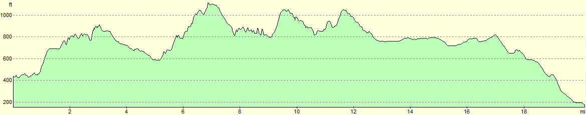
For more information on profiles, ascents and descents, see this page
Transport
The Hadrian's Wall bus operates four services a day between Greenhead and Carlisle in the summer months (generally between April and October). More services stop short of Greenhead at the Roman Army Museum in Walltown; it is about a mile from the musuem down to Greenhead along a minor road and then an off-road cycle path.
Accommodation
I spent the night at the Greenhead Hostel, which is part of the Greenhead Hotel complex. This ex-YHA hostel is roomy and well-equipped, and hearty food is available from the hotel.
 |
 |
|
 |
 |
|
 |
 |
|
 |
 |
|
 |
 |
|
 |
 |
|
 |
 |
|
 |
 |
|
 |
 |
|
 |
 |
|
 |
 |
|
 |
 |
|
 |
 |
|
 |
 |
|
 |
 |
|
 |
 |
|
 |
 |
|
 |
 |
|
 |
 |
|
 |
 |
|
 |
 |
|
 |
 |
|
 |
 |
|
 |
 |
|
 |
 |
|
 |
 |
|
 |
 |
|
 |
 |
|
 |
 |
|
 |
Disclaimer
Please note that I take no responsibility for anything that may happen when following these directions. If you intend to follow this route, then please use the relevant maps and check the route out before you go out. As always when walking, use common sense and you should be fine.
If you find any information on any of these routes that is inaccurate, or you wish to add anything, then please email me.
All images on this site are © of the author. Any reproduction, retransmissions, or republication of all or part of any document found on this site is expressly prohibited, unless the author has explicitly granted its prior written consent to so reproduce, retransmit, or republish the material. All other rights reserved.
Although this site includes links providing convenient direct access to other Internet sites, I do not endorse, approve, certify or make warranties or representations as to the accuracy of the information on these sites.
And finally, enjoy your walking!
Nearby walks
| # | Title | Walk length (miles) |
|---|---|---|
| 44 | Slaggyford to Once Brewed | 18.0 |
| 45 | Once Brewed to Bellingham | 15.4 |
| 929 | Hadrian's Wall Path: Carlisle to Greenhead | 22.2 |
|
|

|