Walk #929: Hadrian's Wall Path: Carlisle to Greenhead
 |
 |
|
General Data
| Date Walked | 24/09/2011 |
| County | Cumbria, Northumberland |
| Start Location | Carlisle bus station |
| End Location | Greenhead |
| Start time | 07.50 |
| End time | 16.14 |
| Distance | 22.2 miles |
| Description | This walk follows Hadrian's Wall Path eastwards. Initially it follows the River Eden eastwards, before climbing into the Pennine Hills. It starts passing isolated stretches of the Wall before coming across long intact stretches. Some of the views from the second half of the walk are superb. |
| Pack | Today I carried my 30-litre Karrimor rucksack, filled with water, my waterproofs, a book and other odds and ends. |
| Condition | I have a little chaffing after this walk, but the biggest problem is with the underside of my feet, which were aching a great deal at the end of the day. |
| Weather | Today was a dry but breezy day, with a mixture of sunshine and cloud blown by the strong breeze. |
| OS map | Landranger number 85 (Carlisle & Solway Firth, Gretna Green) and Landranger number 86 (Haltwhistle & Brampton, Bewcastle & Alston) |
 |
 |
|
Map of the walk
Maps courtesy of Google Maps. Route for indicative purposes only, and may have been plotted after the walk. Please let me have comments on what you think of this new format. For a detailed table of timings for this walk, please see the table file.
 |
 |
|
Notes
I woke up early so that I could get the bus to Carlisle. Not wanting to wake my sleeping Spanish roommate I tried to do as much as possible in the dark, including getting dressed before doing a last-minute check with my head torch and walking to my car to get my boots on. It was then simply a case of walking to the bus stop, which was about a quarter of a mile away on the other side of the railway line. I arrived a good fifteen minutes before the bus was due, but no sooner had I got there than the bus arrived. Surprised, I flagged it down and got on.
Once on the bus I decided to call Sencan. However I could not find my phone anywhere - it was not in my coat or in my backpack. Annoyed, I had little choice but to head to Carlisle and hope I would find it in the hostel when I returned.
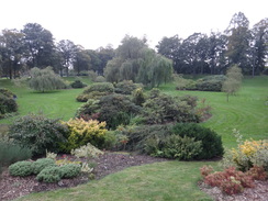
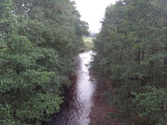
Carlisle was quiet this early on a Saturday morning, and I set out from the bus station to find the bridge where I had left the trail yesterday. Ominous clouds loomed overhead as I joined the trail, which initially followed the river's edge as it looped around, passing through a fairly wild area that was festooned with pink flowers.
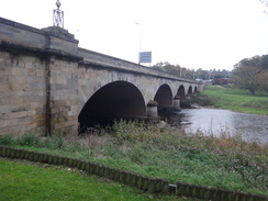
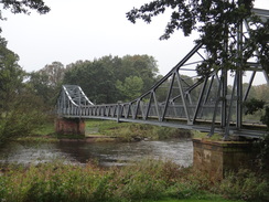
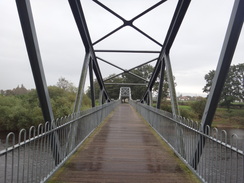
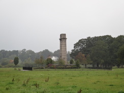
A strange stone sculpture hove into view on the other side of the river - marked as a war memorial on the map - and soon the rather industrial-looking memorial bridge was reached across the river. This was not named after the war memorial in the park, but instead was a war memorial itself, being completed in 1922. It had no real beauty or elegance, but is certainly made an impact on the area.
It started to rain as I crossed the bridge, and it was one of those occasions when I was unsure whether to stop to put my coat on. The rain was not quite heavy enough to force me to stop, and it looked as though it would hopefully end soon. A man passed me in the other direction with a Black Labrador on a lead; the dog was panting heavily, sounding exactly like a steam train going fast - pant,pant,pant,pant. I felt quite sorry for the poor beast, which did not seem to be particularly happy.
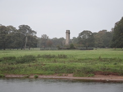
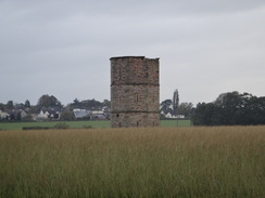
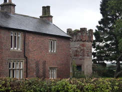
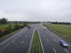
After walking through Rickerby Park and on towards the village of Rickerby itself, where a strange tower could be seen in a field to the left - apparently a previous landowner in the area had been rather fond of follies, and a rather ornate gatehouse beside the road was another example of his work. So far today I had seen little of Hadrian's Wall, and indeed the current route was well south of the wall's course. Another massive construction soon became apparent in the form of traffic noise from the M6. After crossing the motorway the trail passed through Linstock and past Linstock Castle, where another Peel Tower (a fortified tower house rather than a real castle) became visible to the left of the path. Like most extant peel towers this had been heavily converted into part of the farm.
The trail entered the village of Cosby-on-Eden before crossing the A689 on a bridge. Here I met my first east-to-west walkers of the day, a couple of ladies whose dog carried its own food in side-saddles, I expect much to their (if not the dog's) relief. They had had a really enjoyable trip and were bursting with energy and joy; they could not stop telling me how wonderful the next couple of days would be. Hadrian's Wall certainly seems to excite people, and I decided I could hardly wait to see it again.
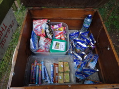
Another track took me north to a road, and here I joined the course of Hadrian's Wall for the first time in the day, although there was nothing to see at this point besides a ditch at the side of the road. A wooden box at Bleatarn Farm denoted itself as the famous stall on the wall'; it operated as an honesty box, but sadly I had no need for any of the items within.
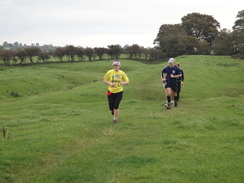
Soon afterwards I noticed someone alternately running and walking from behind. It was a young lad who was attempting to run the trail - he had set off before five in the morning, but his partner had twisted her ankle at Carlisle. He had already wrenched his knee and had left his map with his partner - he seemed sadly ill-prepared and after a discussion he seemed to settle on Hexham for an evening stop. I wished him luck, but even that seemed to be a long way for the lad.
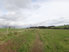
The trail passed the aptly-named hamlet of Oldwall and started to ascend as it headed northeastwards into Newtown. After crossing a main road it continued across a series of fields towards Walton, the halfway point along the trail. On this stretch I started to see what I thought might be parts of the wall, in the form of blocks that had tumbled out of a grassy hedgeline. The trail descended down to Dovecote Bridge, after which there was a footpath diversion - the map showed it heading to the north, but the signs showed it following the road. The signs were official so I followed them until a path led off to the right. It turns out that the diversion is official, although it is hoped that the route marked on the map will soon be opened again.
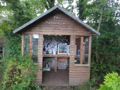
I was now on Hadrian's Wall proper, and there were indications of it in the hedge in the form of small stone blocks. The ascent was steep, and I was surprised to see a sign for refreshments ay Haytongate - a hut selling refreshments via an honesty book. More surprising was an adjacent hut that sold t-shirts about the trail! A couple were sitting on a bench outside and I joined them for a while as a group of charity walkers streamed past.
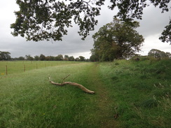
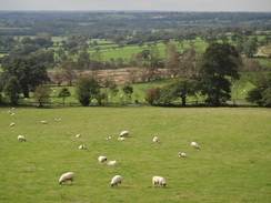
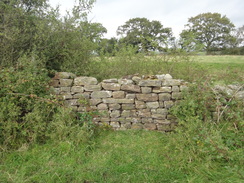
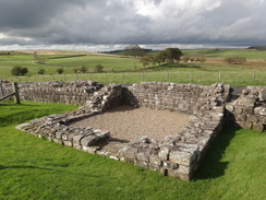
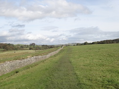
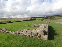
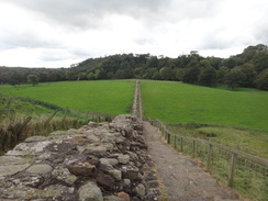
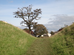
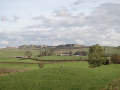
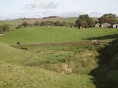
The top of the hill was soon reached, and what followed was a wonderful stretch of path with lots of Roman items to be seen as the trail paralleled a minor road, including regular turrets and mile stations joined by stretches of Wall. Some of these seemed relatively intact whilst others were little more than drystone field walls. It was superb and I felt a literal spring in my step as I walked along.
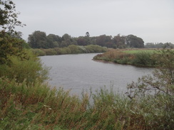
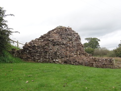
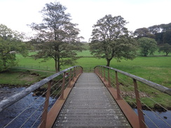
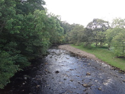
The next few miles were in the same vein, with lots of things to see. In reality there was too much to see, and this trail deserves time to stop and explore. A descent took me down to the River Irthing, where a new bridge crossed beside the remains of the old Roman bridge, which itself was fascinating to walk around.
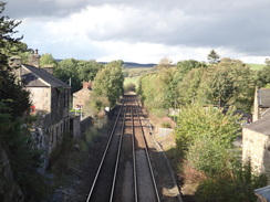
I was getting footsore by now, and had been surprised by how long it had taken me to walk this part of the trail. It seemed prudent to forego the pub at Gilsands and I instead continued along the trail, which left the wall for a short period as it crossed a railway line before rejoining it on a wonderful stretch that granted great views over the crags ahead. Soon I reached the B6318 and headed back to the bunkhouse in Greenhead, where I found my mobile down the backseat of the car.
A wedding party was in the hotel tonight, but the food was good and timely and the company riotous. Talking of which, I am sharing a room tonight with four Irishmen, which should be fun...
 |
 |
|
Directions
This walk starts off at Carlisle bus station at NY403559. Leave the bus station and turn left to head east down Lonsdale Street, and then turn left up the A7 Spencer Street. Stay on the let-hand side of the road; when it reaches a crossroads carefully cross the new road and then continue on along the A7, which is now a dual carriageway. This reaches a roundabout; head through a underpass below the roundabout, aiming for the exit that resumes on the left-hand side of the A7. Do not continue along the road, and instead take a path that parallels the road through a park. This slowly curves to the left before reaching Hadrian's Wall Path beside a road bridge at NY400565.
Turn right to immediately head under the road bridge, and on the other side continue along the path, with the River Eden immediately to the left. The path soon becomes unsurfaced as it follows the river in a big loop to the north, including a short stretch along stone slabs before passing a golf course on the right. After four-fifths of a mile the golf course is replaced by school playing fields; when they end turn left along another path with the river on the left; when this forks take the left-hand path along a path that continues beside the river. After a short distance this reaches the southern end of the Memorial Bridge at NY411564.
Cross the bridge and go through a gate on the northern side. Take the second track off to the right (the first surfaced path); this heads slightly east of north across the parkland, with the large war memorial some way off to the left. After a third of a mile the path ends at a small car park and joins a surfaced road with a cattle grid to the right. Cross the road and then turn right through a gate that leads onto a cycle path. The path immediately crosses a footbridge over Brunstock Beck and continues on parallel to the road in a rough easterly direction past the village of Rickerby and a series of follies; after 0.6 miles it approaches a cottage at NY419572 the cycle path ends and turns right to join the road.
Turn left and follow the road northeastwards; after half a mile it curves around to cross a bridge over the M6. Continue along the road for another couple of hundred yards and then take the first road off to the right; this immediately turns to the left to head northeastwards along another road through the village of Linstock. After a quarter of a mile the road curves to the left; as it does so continue straight on along a rough track, signposted for Crosby.
The path curves to the right and then left to continue northeastwards between hedges past the farm at Linstock Castle, passing under high-tension power lines on the way. Shortly after the castle the track jinks to the left (ignore another track coming in from the right) and continue on until a clapper gate is reached beside a field gate. Go through the gate and turn right to head down another track with a hedge on the right.
Follow this track southeastwards for 250 yards until it approaches the northern bank of the River Eden; at the end of the field turn left; soon afterwards it climbs up onto the top of a bank that gives good views over the river to the right. This path curves to the right and eventually becomes a track; this goes through a metal clapper gate and crosses a concrete bridge over a stream near Eden Grove (NY440591). On the other side of the bridge the path curves to the right and to follow the stream on the right until it reaches the river once more. Here turn left to follow a path with the river on the right. It passes under another set of high-tension power lines to reach a cream building at the end of the field; here it curves to the left, passing the building on the right. Go through a clapper gate to join a track called Green Lane. This heads northeastwards to end at a T-junction with a road in Crosby-on-Eden at NY446594.
Turn right and start following the road eastwards through the village for half a mile, passing the church and leaving the village. Just before a road comes in from the right, turn left through a clapper gate and follow a path north, with a fence on the left and a hedge on the right. After a short distance it goes through another gate to reach a concrete track. Head across this to a third clapper gate that leads to a path that continues on between fences, with the track over the fence to the left. The path climbs up the approach ramp to a bridge and then turns left through a fourth gate to join the track as it heads over a bridge over the A689 road. Immediately on the other side of the bridge turn right through anther gate to join a narrow path with a fence on the left; this soon ends at final gate beside a track junction at NY453599.
Turn hard right to join the new track and follow it as it curves to the left with some woodland to the right. This ends at a stile beside a field gate; cross the stile to reach a T-junction with another track called Sandy Lane. Turn left and follow Sandy Lane as it heads north, initially with some woodland on the left. After half a mile it ends at a T-junction with a public road at NY453608, alongside the course of Hadrian's Wall although, sadly, no sign of the wall is in sight.
Turn right and follow this road east-northeastwards for a third of a mile; as the road curves to the right beside Wall Head Farm continue straight on along a surfaced track with a hedge on the left. After 300 yards the track curves to the left; continue straight on along a grassy footpath, initially with a hedge on the left. It crosses a clapper gate through a hedge and heads on; the hedge curves away to the left as the path heads straight on across a lumpy and bumpy area of ground.
It crosses a couple of clapper gates at the end of this field, with Bleatarn Farm a short distance away to the right before continuing on along a path between hedges. After a short field go through another clapper gate and turn left down a track for about five yards before turning right up some stone steps to another clapper gate. Go through another couple of clapper gates across fields keeping a hedge on the left.
At the end of the next field go through a clapper gate and turn left, keeping a hedge on the left across another field. At the end of the field go through another clapper gate and continue on, still with the hedge on the left. When this field ends go through a gate, cross a footbridge over a stream to another gate and continue on, still with the hedge to the left. Finally go through another clapper gate that leads onto a road at Oldwall at NY479616.
Cross the road and continue straight on along a surfaced track; as this curves away to the left cross a stile and continue straight on along grass with a hedge on the right and Oldwall Farm on the left. It reaches a gate that leads into a green lane with hedges on either side; a third of a mile after leaving the farm this emerges through a clapper gate into a field at NY487617. Turn half-left to keep the hedge on the left as it winds slightly before taking a northeasterly course.
Cross a clapper gate and head on with a hedge on the left. This field is long; cross another clapper gate at the top left-hand corner of this field and continue straight on with a fence on the left. Cross a clapper gate to enter another field and head on with a fence and intermittent hedge on the left. At the end of this field go through a clapper gate and head on, now with the fence on the right. After a short distance go through another clapper gate and continue with the fence still on the right; at the end of this field turn right through a clapper gate to reach a bend in a road at NY495623. Head straight on along this road to head northeastwards for 0.4 miles until it ends at a T-junction with the A6071 in Newtown at NY500627.
Carefully cross the main road and on the other side continue on along a track. It turns right into a little courtyard area and then left, keeping a fence on the left and a low wall on the right. This immediately curves to the left to squeeze between a shed and a fence, before heading across some grass to a clapper gate. On the other side continue on with a fence and then a shed on the right to another clapper gate. Go through this and continue with a fence on the left to a third gate. Continue straight on across a field. At the end of this field go through another clapper gate and follow the path as it curves slightly to the right to join a fence on the left; Heads Wood Farm is beyond the fence.
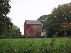
Skirt a lovely stone house on the left and then head steeply downhill along stone steps to reach a clapper gate through a hedge at the bottom. Cross some stone slabs and continue on with a hedge on the right until it approaches The Beck Farm at NY505634. At the farm turn left and then right, keeping a barn to the right to reach a clapper gate through a hedge. On the other side turn right with a fence on the right and a stream on the left; after about twenty yards a footbridge over the stream is reached.
Turn left to cross the footbridge and go through a clapper gate to enter a field. Keep a hedge on the right towards the farm at Cambeckhill. At the end of the field go through a field gate and pass a barn on the left before reaching the farm proper at NY507636.
Continue through the farmyard and then turn right down a track for a few yards before turning left through a clapper gate into a field. Do not go through a gate ahead, but continue on with a fence on the right to a clapper gate that leads into another field. Another clapper gate leads into a third field; on the other side turn left along a broad path through trees. The path descends some stone steps to reach a footbridge over the Cam Beck at NY510639.
Turn right to cross the arched footbridge and follow the path as it climbs up steps on the other side to reach a stile. Go through this and turn half-left to follow a path, keeping a fence on the right and the field on the left. This heads up a slight hill; at the top of the field go through a clapper gate over a fence and turn left north along a track for about five yards to reach two gates. Go through the right-hand gate and follow the track northeastwards with a hedge on the left. It passes a large barn on the left to reach a track that soon reaches a cattle grid that leads onto a public road. Take a clapper gate to the right of the gate and then turn right down another track that leads south towards the farm at Sandysike.
Just before the farm is reached, turn left across a clapper gate to join a path that heads through an area of woodland. The obvious path curves to the right as it heads through the trees to descend to cross a slab bridge over a stream. Go through a clapper gate on the other side and start following a path across a field with a hedge on the right. At the end of this field the path becomes a track with gardens the left; it goes through another clappergate before ending in a road at Walton at NY521642.
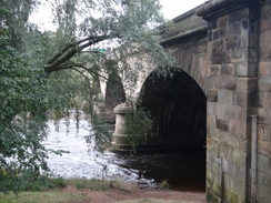
Turn left and follow the road as it heads northeastwards; as the road curves to the left opposite the Centurian Inn (now closed?) and head straight on along another road. This immediately curves sharply to the right and descends downhill to cross King Water at Dovecot Bridge. The trail will soon head off to the left on the other side, but a long-standing diversion continues up the road for exactly half a mile until the line of the Wall is rejoined at NY534643.
When a whitewashed cottage is reached on the left, pass a track on the right and then turn right through a wooden clapper gate to enter a field. Head eastwards across a field keeping a hedge on the right; it goes through a clapper gate to continue with a hedge on the right; small pieces of the Wall can be seen below the hedge. At the end of this field go through a clapper gate and continue across a field with a fence on the left towards another clapper gate. Go through this and descend onto a surfaced lane at NY539643.
Cross the lane and go through a clapper gate on the other side. Head on eastwards across a field, keeping a hedge to the left. It descends stone steps and crosses a stone bridge over a boggy area before heading on up the field. Near the top of the field turn left and then immediately right through a clapper gate; on the other side turn left into a field, keeping a fence to the left. The path soon curves to the right to head eastwards with a fence on the left to reach a clapper gate that leads out onto a road at NY543644.
Turn right to head south along the road for about eighty yards, and then turn left through another clapper gate to head down some stone slabs. At the end of this field it goes through a clapper gate and continues on for a short distance to another clapper gate. Go through this and continue with a hedge on the left. The path heads downhill; pass through a clapper gate halfway down the field and then another at the bottom of the field. This leads to a footbridge and then a clapper gate, after which the path starts heading uphill.
At the top of the hill go through a clapper gate and continue with a fence on the right and a hedge on the left. Go through a pedestrian gate to reach Haytongate Farm. A few yards further on there are some benches and the rather infamous Haytongate honesty hut, where food and drink can be bought and Wall-specific clothing ordered. Continue on uphill from the farm, keeping a drystone wall on the left, crossing stiles and gates on the way as the views unfold in all directions. The gradient slackens; at the end of a field cross a ladder-stile and continue on with a hedge and wall on the left. Go through a clapper gate and continue on as it approaches the farm at Hare Hill.
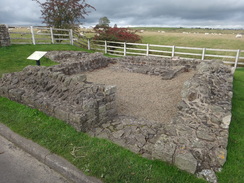
Do not go through the farm gate ahead, and instead turn right beside it, keeping a fence to the left. At the end of the field go through a clapper gate and turn right along a farm access track; this heads steeply downhill, passing Milecastle 53 on the left before ending at the road in Banks at NY565646.
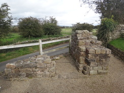
Turn left along the road and after a short distance turn right along another road that starts to climb uphill once more. When the road ends at a T-junction turn left to continue straight on uphill along the road as it heads eastwards through Banks. At NY572646, cross a stile to the right and follow a path with a wall and the road to the left. This leads to the first stone stile of the day that leads back onto the road beside a good remnant of the Wall, including Turret 52A. Turn right, keeping the Wall to the left, and head towards a car park. Cross this and go down some steps on the other side to continue on with a drystone wall to the left and a fence to the right. At the end of the path go up some steps towards reach Pike Hill Signal Tower, which is at an angle to the Wall.
Just before the ruins of the signal tower are reached, turn right through a clapper gate and head on along a path which heads across rough ground below a stone wall. Walk along the field with the wall on the left; at the end of the field cross another stone stile onto the road and turn right to follow the road eastwards, passing a farm on the right. After passing the farm turn right through a clapper gate at NY580649 and turn left, with a wall and the road to the left.
At the end of this long field climb a stone stile and enter another field, still with the wall on the left. Soon afterwards go through a stile to enter another field; at the end go through another stone stile to rejoin the road. Turn right to follow the road east-northeastwards, passing Turret 51A on the left. When a road comes in from the left, turn right, initially down the driveway into a cottage and then down a footpath. After a short distance turn left along a footpath that heads through some woodland.
As the woods end, go through a clapper gate and continue across stone slabs and then between fences; this stretch has been realigned, and could be in the future. The path soon curves to the left, heading back towards the road. It then runs parallel to the road with a fence to the right. The path curves to the right, crossing a little footbridge before turning to the right to join a track. Turn right down the track; after a short distance turn left through a gate and climb up some steps to enter a field. Head east across this field, paralleling the bumps of the ditch of the original turf wall on the right.
At the end of this path head through a clapper gate and continue on with a fence on the right; it crosses several more clapper gates as it slowly rises before meeting a stone wall at NY609659. Climb the stone stile over the wall and then immediately turn left, keeping the wall on the left as the path heads downhill. At the bottom of the hill it meets a stone wall; here the path turns to the right, paralleling the wall and with the road on the other side. Pass a turret on the left and continue on uphill; at the top of the field go through a clapper gate and head on, still with the fence and wall to the left.
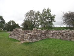
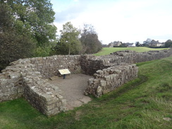
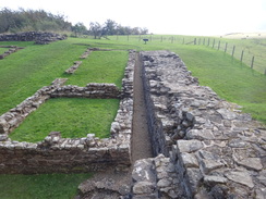
Near the top of the field the path curves slightly to the right, aiming for a clapper gate near a tower house. Go through the gate and follow the path as it curves to the left and then the right to go through a clapper gate and join the road at NY614663. Turn right and follow the road as it heads past the entrance to Birdoswald Roman Fort (now in the care of English Heritage). After passing the entrance to the fort, turn right off the road and the left to follow a good path with the Wall to the left and a fence to the right. After passing the walls of the fort on the right, go through a clapper gate and enter a field, with the Wall to the left.
When the road curves away to the left, continue straight on with the Wall to the left. At the bottom of the field go through a clapper gate to enter Milecastle 49. Follow the path as it curves to the right past the milecastle; it soon turns right down a steep gravel track. About two-thirds of the way down, turn left down some stone steps. At the end of the steps continue on with a fence on the left to more steps. Turn right through a gate and turn left to reach a footbridge over the River Irthing at NY621663.
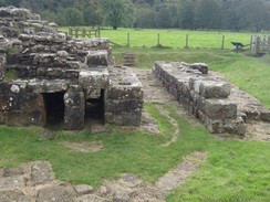
Cross the footbridge, keeping an eye out for the remains of the abutments of the Roman bridge to the left. On the other side of the bridge turn left through a pedestrian gate and follow the path, initially alongside the river before curving to the right across slabs to another gate. Go through this to head to a clapper gate to reach the startling remains of the Roman bridge.
As soon as you go through the gate turn left, keeping the ruins to the right to another gate. Continue along a path that leads to some steps that lead steeply uphill. Go through a gate and climb the steps with the wall to the right. The path levels out; go through a pedestrian gate and continue along a track with Willowford Farm to the right. After a few yards climb up some wooden steps to rejoin the wall on the left.
Keep the wall on the left and go through a gate to reach a turret and continue on. All of a sudden the Wall ends; go through a gate and continue on along a farm track with a low stone wall to the left. The Wall soon restarts as the track climbs to reach another turret. Shortly after this the Wall jinks to the left; when it reaches a barn turn right through a little gate to reach a road beside a cattle grid in Gilsland at NY630662.
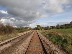
Turn right down the road for a few yards and then turn left through a clapper gate to join another path that initially runs along some stone slabs, but then runs along grass as it curves to the left to reach a little stone bridge over a stream. On the other side of the bridge the path continues to curves to the left to reach a clapper gate, then climbs uphill to reach a railway line. Carefully cross this and go through a clapper gate on the other side before turning to the left to parallel the railway line.
Go through a gate and turn left to climbs a few steps, with Milecastle 48 on the right. Go down some more steps; at the bottom cross a footbridge over a stream; off to the left is a very tall arch of a railway viaduct. Climb up some more steps, cross a tiny footbridge and curves to pass what used to be a railway station on the left. Turn right through a gate and then a clapper gate to follow a fence on the left. At the top of the hill turn left through a gate and continue across a field. At the end of the field go through a gate to reach a road at NY636662.
Immediately turn left up a track and then right up some stone steps to reach a gate. Head on along the course of the ditch to reach a ladder-stile over a wall. Walk past some gardens on the right to reach a gate; go through the gate and continue across a small field to a clapper gate that leads onto a road. Turn right down this road for a few yards and then left over a ladder-stile to continue across another field. Go through a gate and head down a slight slope, still following the Wall on the right. At the end of the field cross a ladder-stile over a wall and continue down a track through a farm. Follow the track as it curves to the right and then turn left through a gate which leads to a path that passes the farm. Go through another few gates and cross a footbridge over a stream.
On the other side of the footbridge turn left; join a wall on the right and follow this to a clapper gate; go through this and continue with the wall still on the right. At the end of this field go through another clapper gate and continue on, with a deep ditch to the left and the wall on the right. Descend down into the ditch when you safely can and follow this as it heads downhill to a footbridge over a stream.
Cross a clapper gate on the other side of the stream and continue straight on across a field; the ditch and wall now have more or less disappeared. Go through a clapper gate and continue with a wall on the left; this descends downhill to a ladder-stile. Cross this and descend some steps to reach the B6318 road. Turn right to follow this road southeastwards; after a couple of hundred yards the trail heads off to the left beside some cottages at NY657659.
However today's route heads on along the B6318 for a little under half a mile into the village of Greenhead. When it ends at a T-junction with another road, turn left and follow this road as it immediately crosses over a railway line. This walk ends at the Greenhead Hotel on the right, at NY659653.
 |
 |
|
Distances
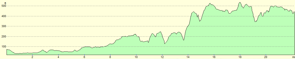
| From | To | Distance (m) | Ascent (ft) | Descent (ft) |
|---|---|---|---|---|
| Carlisle bus station | Crosby-on-Eden | 5.3 | 112 | 118 |
| Crosby-on-Eden | Walton | 6.6 | 384 | 200 |
| Walton | Gilsland | 8.3 | 1060 | 843 |
| Gilsland | Greenhead Hotel | 2.0 | 131 | 161 |
This makes a total distance of 22.2 miles, with 1687 feet of ascent and 1322 feet of descent.
For more information on profiles, ascents and descents, see this page
Transport
The Hadrian's Wall bus operates four services a day between Greenhead and Carlisle in the summer months (generally between April and October).
However, a much more frequent service is operated by Arriva Bus. Their Service 685 runs between Newcastle and Carlisle, but does not call at Greenhead. However it does call at a bus stop on the A69 about a quarter of a mile south of the village; a track leads south past the church to reach a pedestrian crossing over the railway line. Cross the railway and take a bridge under the main road, then turn left to reach the bus stop beside the road. This is a much more convenient service than the Hadrian's Wall bus.
Accommodation
I spent the night at the Greenhead Hostel, which is part of the Greenhead Hotel complex. This ex-YHA hostel is roomy and well-equipped, and hearty food is available from the hotel.
 |
 |
|
 |
 |
|
 |
 |
|
 |
 |
|
 |
 |
|
 |
 |
|
 |
 |
|
 |
 |
|
 |
 |
|
 |
 |
|
 |
 |
|
 |
 |
|
 |
 |
|
 |
 |
|
 |
 |
|
 |
 |
|
 |
 |
|
 |
 |
|
Disclaimer
Please note that I take no responsibility for anything that may happen when following these directions. If you intend to follow this route, then please use the relevant maps and check the route out before you go out. As always when walking, use common sense and you should be fine.
If you find any information on any of these routes that is inaccurate, or you wish to add anything, then please email me.
All images on this site are © of the author. Any reproduction, retransmissions, or republication of all or part of any document found on this site is expressly prohibited, unless the author has explicitly granted its prior written consent to so reproduce, retransmit, or republish the material. All other rights reserved.
Although this site includes links providing convenient direct access to other Internet sites, I do not endorse, approve, certify or make warranties or representations as to the accuracy of the information on these sites.
And finally, enjoy your walking!
Nearby walks
| # | Title | Walk length (miles) |
|---|---|---|
| 44 | Slaggyford to Once Brewed | 18.0 |
| 45 | Once Brewed to Bellingham | 15.4 |
| 439 | Angerton to Burgh by Sands | 17.3 |
|
|

|