Walk #131: Ipswich to Wickham Market Station
 |
 |
|
General Data
| Date Walked | 30/12/2000 |
| County | Suffolk |
| Start Location | Ipswich Station |
| End Location | Wickham Market Station |
| Start time | 09.17 |
| End time | 15.32 |
| Distance | 16.7 miles |
| Description | This was a very nice walk, initially road walking but later following paths along estuary and riverside banking before heading across fields. |
| Pack | Today I carried my Craghoppers 70-litre rucksack with no tent. |
| Condition | I have a couple of slight hotspots on both of my feet, but nothing that will turn into blisters. I am slightly fatigued, but this is to be expected after a long walk with only one stop. When I got back to Ipswich Station I had to walk back to my car, and I was felt fine for that walk. |
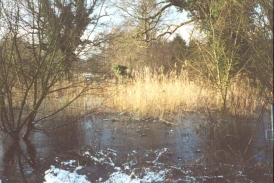
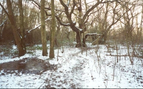
| Weather | Cold! There was still snow and ice on the ground from the storms earlier in the week. It was warm in certain places if I was out of the wind and the sun was shining on me, but in places exposed to the wind it got fiercely cold despite my fleece. At one stage there were some snow flurries in the air, but it was generally a sunny day. |
| OS map | Landranger number 156 (Saxmundham, Aldeburgh & Southwold) and Landranger number 169 (Ipswich & The Naze, Clacton-on-sea) |
 |
Map of the walk
Maps courtesy of Google Maps. Route for indicative purposes only, and may have been plotted after the walk. Please let me have comments on what you think of this new format. For a detailed table of timings for this walk, please see the table file.
Notes
This was a lovely walk, despite the initial section of it being along roads. Fortunately the roads either had pavements or were relatively quiet which meant that I felt relatively safe. I made a mistake at the start of the day by parking at the University College car park (a car park that is open on Saturdays only), and having to walk from here to the railway station before I could start my walk. This mistake did allow me to view the area around the docks which was very interesting, particularly the way it has recently been regenerated.
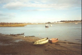
Between Woodbridge and Melton I met a nice local lady whom I chatted to about the local area. At one time she worked in Cambridge, so we also talked about the Fens. The river Debden on this section had many boats on it, some of which were half-sunk and rotting. Apparently every few years a clear-out of all the hulks is performed, and the river is clear of them until the next big storm when another one or two sink! There were also some small ex-navy gunboats on the river which had been converted into homes. They were both painted in a dour navy grey, but looked very homely nonetheless.
The highlight of the walk was definitely the section between Martlesham and Woodbridge, where I walked along the northern bank of Martlehsam Creek to Kingston, and then along the western bank of the River Debden. At the western end of Martlesham Creek was a sign saying that this path was liable to become flooded at Kinsgton at high tides. Since the tide was quite high I asked a local birdwatcher if it would be okay. He said that it only flooded at very high tides, and so I put my fears to one side and walked along. It really is a beautiful section of estuary walking.
The path between Woodbridge and Melton met a road at Wilford Bridge on the A1152. The OS map shows a track and later a path heading off here to the north-northwest which was the direction that I wanted to head. I searched for this path for a period, concentrating on the area alongside the pub, but unfortunately I did not find the path. This meant that I had to extend the walk by walking into Melton and then north up the B1438 for a short distance. Whilst this extended the walk, I was not too bothered as long as I had time to get to the station in time.
I wanted to catch the 16.04 train from Wickham Market Station, so I was in a bit of a hurry for the section of the walk north from Melton. Fortunately I got to the station about half an hour before the train was due to set off. This meant that I had a very cold wait in the shelter on the platform, as when the sun went down the temperature dropped rapidly. I would have gone into the pub that is outside the station to keep warm but unfortunately it was shut.
Mud has been a recurring feature during my walks over the last few months, but fortunately it did not feature too strongly on this walk due to the fact that the ground was mostly frozen. Only in a couple of places did my feet sink through to any mud, and these were mainly in wooded areas around the western end of Martlesham Creek.
This walk was the first stage of a four day walk north up from Ipswich to Lowestoft, which in turn is part of my walk around East Anglia. It is nice to be start a new section of this walk, and hopefully by the end of January I will have reached Lowestoft and be ready to start the walk to Great Yarmouth and Cromer.
Directions
This walk started at the College University car park in Ipswich, a Saturdays-only car park that was easy for me to get to. My first aim was to get to the main railway station in Ipswich, which was a little over a mile away to the northwest on the other side of the river. To do this I turned left out of the car park and headed down road Cliff Lane. At the T-junction I turned right down Holywells Road and then immediately left down another road to meet Cliff Road. I then turned right down Cliff Road for a short distance before turning left down Launch Road to meet the side of a quay. From here I turned right and followed the side of the quay northwards past some warehouses until I met Bridge Street beside a bridge over the river. Turn left and cross the river and then turn right down Burrell Road. The railway station is about 500 metres ahead on the left-hand side of Burrell Road
From the railway station head straight ahead to the north and cross the river by the bridge carrying Princes Street. Pass under the roundabout where Princes Street meets Civic Drive using the subway and straight ahead. Take the first road to the right and continue eastwards along Tacket Street. Continue straight over Bond Street along Rope Walk and follow it until it ends at a T-junction.
Turn right along St Helens street and when the road bends sharply to the left continue straight on up Spring Road. Pass under a high railway viaduct and follow the road until it meets Woodbridge Road. Follow this Woodbridge Road eastwards past two roundabouts and then take the first road to the left, called Playford Road. Head north-eastwards up Playford Road as it passes Playford Heath and slowly makes its way up to the top of Beacon Hill. Continue along the road as it passes over the A12(T) and descends to a crossroads.
Cross over the crossroads and head straight ahead along School Lane. Just after the first road to the right a footpath leads off to the left. Take this footpath as it heads eastwards through an area of woodland. When it meets Martlesham Creek take another footpath to the left that leads past the end of the creek. Turn right at the other side of the Creek and follow another footpath along the northern edge of the Creek. The path then bends around at Kingston and follows the seawall of the western bank of the River Debden northwards into Woodbridge, where the station can be found to the left of the path.
Continue north following the riverside path which winds northwards through the marina area of Woodbridge. After a short distance it breaks out of this area and starts following the seawall once more northwards until it meets the A1152 road just east of Melton railway station. Turn left down the A1152 and follow it past the station. Take the first road to the right (Station Road) past the church to a T-junction with Yarmouth Road. Turn right along Yarmouth Road and head uphill. Near the top of the hill turn right along a road that heads eastwards towards a church. The road bends around to the north at the church (the corner can be cut off by using a footpath that heads across a golf course) and ends at a T-junction in the village of Ufford.
Turn left down Lower Street and follow it as it bends around to the north, becoming Barrack Lane in the process. Shortly after the junction with East Lane take a footpath to the right that heads north-northeastwards across fields to meet a track near Loudham Hall. At the track the path veers off slightly to the right to meet another track at a T-junction. Head straight down this track to the northeast through Park Farm to meet Loudham Hall Road.
Follow Loudham Hall Road as it twists around a lake beside a mill. When the road bends sharply to the right just past the lake take a footpath that heads straight on to meet another road. Cross the road and take the footpath opposite that leads across fields to meet the railway line and follow it into the little village of Campsey Ashe. Just past some allotments take the first road to the left and then turn right along a road for a shot distance to meet the B1078. Campsey Ashe station is a short distance ahead on the right.
Distances
| From | To | Distance (m) | Ascent (ft) | Descent (ft) |
|---|---|---|---|---|
| Ipswich College University Car Park | Woodbridge Station | 10.1 | 318 | 341 |
| Woodbridge Station | Wickham Market Station | 6.6 | 289 | 217 |
This makes a total distance of 16.7 miles, with 607 feet of ascent and 558 feet of descent.
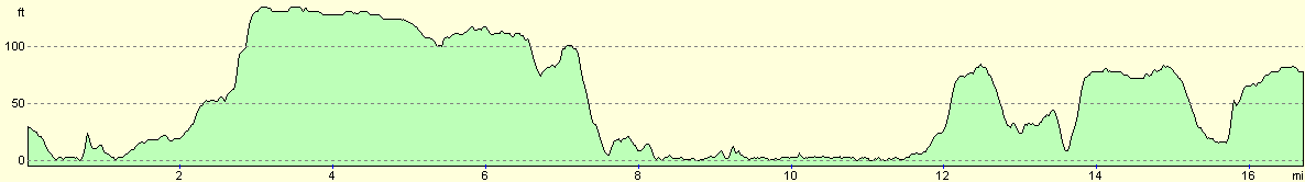
For more information on profiles, ascents and descents, see this page
Transport
There are train services between Wickham Market and Ipswich stations, calling at Melton and Woodbridge on route. These services run every couple of hours. Note that Wickham Market Station is actually situated at Campsey Ashe, a few miles east of the town.
Disclaimer
Please note that I take no responsibility for anything that may happen when following these directions. If you intend to follow this route, then please use the relevant maps and check the route out before you go out. As always when walking, use common sense and you should be fine.
If you find any information on any of these routes that is inaccurate, or you wish to add anything, then please email me.
All images on this site are © of the author. Any reproduction, retransmissions, or republication of all or part of any document found on this site is expressly prohibited, unless the author has explicitly granted its prior written consent to so reproduce, retransmit, or republish the material. All other rights reserved.
Although this site includes links providing convenient direct access to other Internet sites, I do not endorse, approve, certify or make warranties or representations as to the accuracy of the information on these sites.
And finally, enjoy your walking!
This walk was mentioned in the following routes:
| A walk around East Anglia |
Nearby walks
| # | Title | Walk length (miles) |
|---|---|---|
| 107 | Stowmarket to Ipswich | 16.1 |
| 132 | Wickham Market Station to Darsham Station | 12.7 |
| 261 | Aldeburgh to Chillesford via Orford | 17.8 |
|
|

|