Walk #207: Shippea Hill to Thetford
 |
 |
|
General Data
| Date Walked | 23/07/2002 |
| County | Cambridgeshire, Suffolk, Norfolk |
| Start Location | Shippea Hill Station |
| End Location | Thetford Station |
| Start time | 07.51 |
| End time | 15.16 |
| Distance | 20.2 miles |
| Description | This was a walk of two halves; a first half along the flat Fens with expansive views to Brandon was followed by a riverside walk through forestry land to Thetford. |
| Pack | I carried my Karrimor 30-litre rucksack which contained a coat, fleece, spare batteries and the usual odds and ends. |
| Condition | I feel relatively fine after this walk. I had some of the pain under my left shoulder that has been troubling me occasionally since before Christmas, so I decided to take it easy. The biggest problem I had was with my feet, and I had two large blisters on the fourth toes on each foot, which was caused by the fact that I was using my old pair of boots for the first time in many walks. |
| Weather | The weather was nearly ideal for walking, with a mainly cloudy sky giving occasional glimpses of the sun. There was a little wind that helped cool me down, and there was no sign of any rain. It was fairly warm, but not enough to make me sweat too much (which was helped by the fact that the route was fairly flat and I therefore did not have to exert myself too much). |
| OS map | Landranger number 143 (Ely & Wisbech, Downham Market) and Landranger number 144 (Thetford & Diss, Breckland & Wymondham) |
 |
 |
|
Map of the walk
Maps courtesy of Google Maps. Route for indicative purposes only, and may have been plotted after the walk. Please let me have comments on what you think of this new format. For a detailed table of timings for this walk, please see the table file.
 |
 |
|
Notes
This walk is the latest part of my sectional walk from Ely up to Norwich and then the northeast Norfolk coast. It was very much a walk of two halves; the first half was a nice stroll along flat fenland, and the second half was through woodland and along the Little Ouse river.
For the first time in a few walks I was using the pair of Salomon boots which I used on the Pennine Way, which are usually fairly comfortable. However fairly early on my feet felt cramped, and before I reached Brandon I could feel a blister starting to form on the fourth toe on my right foot. It is unusual for me to get a blister so early on in the walk, and I am at a loss as to why this walk caused one to form.
As I approached the village of Brandon I was greeted with a flight of five planes coming in to land at the US air force base at Lakenheath. They all circled around as one by one they came in to approach, and this made an impressive if noisy sight. It made me wonder exactly how the people who live in the village cope with all the noise. Is suppose that some of the effects of the noise are offset by the extra trade that the airbase brings into the surrounding area, and I would think that you would get used to it after a while.
I stopped off at The Bell public house in Brandon so that I could have a drink and a short rest. Once I had sat down I found that I could not really relax and I felt an urge to continue the walk, so I cut the rest period short and set off once more. This was a strange decision as I was not under any pressure time-wise, so I am at a loss as to why I felt the need to hurry.
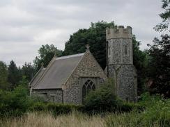
The last part of the walk from Brandon to Thetford was probably the nicest stretch of the walk, with a mixture of forestry and riverside walking. In particular the little church at Santon was very nice - it used to be the centre of a medieval village but now only one house remains apart from the church. The church itself was very nice, with an unusual spire setting off it's rural location.
As I walked into the centre of Thetford I was greeted with a surprise - Thetford priory is marked on the map but when I reached it I found that the ruins were very similar to those at Bury St Edumunds to the south. I walked around the ruins for a few minutes before heading out to the 14th-century gatehouse, which was a most impressive structure that was nearly complete. It is very nice seeing such a complete part of a priory as most such buildings are now mostly or completely ruined. The priory was dedicated to St Mary, and was a Cluniac Priory. It was built in 1104 by Roger Bigod, a friend of William the Conqueror.
The way marking on the route was absolutely terrible. The Hereward Way to the west of Ely was fairly well signposted, but I could not find any signposts on this stretch. This could be due to the fact that the walk is in a different county(Suffolk and Norfolk as opposed to Cambridgeshire), and indeed I found general signposts on the Suffolk stretches to be fairly poor.
I had a choice to make when I got to the southern end of Stallode Wash by Russell Farm. I could either continue along the road into Lakenheath, or I could walk up the eastern side of the wash, following the Hereward Way. After weighing up the alternatives I decided to continue along the road that was a slightly shorter but less scenic route. Unfortunately this choice involved walking along the B1112 road, which was busier than I had thought it would be. It was not dangerously so, but I must admit that the Hereward Way route would probably have been preferable.
When I got to the station I was relieved to see that a train was due in about ten minutes. Unfortunately as I sat on a platform bench I could see that it was progressively getting later. The train eventually came in at about twenty past four, which was fifty minutes late, and it got into Ely about an hour late, which meant that Sam had been waiting to pick me up for twenty minutes.
I am now set up to reach Norwich in another two day's walking; firstly by walking from Thetford to Attleborough and then from Attleborough to Norwich. I hope that I can complete these two walks sometime in the next few weeks, so I can then concentrate on connecting Norwich with the Norfolk coast.
Directions
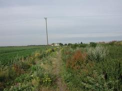
This walk starts off at Shippea Hill station, which is on the Norwich to Peterborough line, and it follows the Hereward Way in part. Leave the station car park to meet the A1101 road. Immediately opposite the entrance to the car park is a green track that leads off eastwards to the south side of the railway line. There was no signpost marking this path, but as it was marked on the map as being part of the Hereward Way I assume that it is a public right of way.
The track follows the railway line for two kilometres until it reaches a large barn, crossing the border between Cambridgeshire and Suffolk on the way. Here the track becomes surfaced and starts to head away from the railway line across Sedge Fen. Continue along the road, past a surprisingly modern-looking church until the road ends at a sharp bend to the left. At the bend continue straight on along a track that passes a house with a modern extension before turning to the right to head south to meet a road near Russell Farm.
Join the road and follow it past Russell Farm. It makes a sharp bend to the left before turning to the right. At this bend the road meets the end of Stallode Wash, where an alternative footpath route can be used to get to Lakenheath Station avoiding road walking. If you choose the road route, then follow it from Saltlode Wash southeastwards to cross a bridge over the cut-off channel, which is immediately followed by a T-junction with the B1112 road in Lakenheath.
At the junction turn left and follow the B1112 as it heads north for a short distance before turning to the right to head north-eastwards out of the village. Whilst the road is in the village there is a pavement, but once outside it ends, leaving you to the mercy of the road traffic. The road curves around to head northwards and meets the cut-off channel once more, before heading north for two kilometres towards Lakenheath Station.
Just before the station is reached, turn right beside Hiss Farm and follow a track that leads eastwards. This crosses the cut-off channel once more before skirting the southern side of the railway line for a couple of miles. The track approaches the railway line before it turns slightly to the right to head away from it. At a junction with another track turn left to head eastwards along Chalk Road past Foord House towards Brandon. At another T-junction take a footpath that continues straight on across a field and ends at Manor Road in the town.
Turn left onto Manor Road and continue on towards the church. When the road turns to the left continue straight on down Church End. When the church is reached pass through the churchyard and out onto Church Road once more on the other side. Follow this road past the graveyard until it ends at a junction with the A1065 London Road. Turn left and follow the A1065 for a short distance until it meets the main crossroads in the town. At the crossroads turn left to head north along the A1065 High Street towards the station for a short distance.
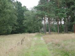
When Whitehouse Lane is reached on the right turn down it and follow it. At another junction it ends but an unsurfaced road, Gashouse Dove, continues straight on eastwards out of the town. After a while the houses to the right stop and the track becomes rougher. Follow it as it turns to the left to head northwards past a stables where it turns to head north-eastwards and enters a wooded area - part of Breckland Forest. Enter the forest and when the track turns sharply to the right to head southeastwards, continue straight on along a footpath that follows St Edmunds Way. This eventually leaves the forest and enters the little village of Santon Downham.
In the village join the road and follow it as it passes the church. A few hundred metres further on a track leads off to the left through the forest. Follow this track as it heads in a roughly easterly direction. A little under a kilometre along the track a path leads off to the left, crossing the Little Ouse river and emerging at a car park on a road. Turn right and follow the road until it ends at Santon Church.
At the church join St Edmund Way, which will be followed all the way to Thetford, as it heads to the left, passing through a small cattle creep under the railway line; on the other side of the bridge turn right along a track that heads eastwards through the forest, with the railway line down below to the right. The track ends at the A134 road; turn right to head southeastwards down the A134 for a short distance before turning right down another track, signposted for a Cub and Scout camp.
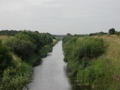
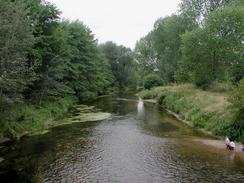
When the track immediately forms take the left-hand fork, and head under a low bridge under the railway line to reach a large expanse of ground. Walk down towards the river, and then turn left to walk along the ground towards a large factory. Head to the right of the factory along a footpath that squeezes between the river and the factory grounds, and on the other side cross some waste ground, with the river out of sight below to the right. The path soon leaves the waste ground and enters woodland, plunging southwards through the trees. After half a mile in the trees the path turns slightly right to meet the river bank, and continues south with the river in close company to the right to reach Abbey Heath Weir.
The river continues to twist around, eventually passing some lakes on the left and passing under the A11 dual carriageway bridge to reach the outskirts of Thetford. Continue along the path as it settles on a more easterly course for about a mile from the A11; when the surfaced path ends head on along the grass with the river on the right until a large road bridge is reached near the ruins of the priory. Here turn left to join London Road which runs over the bridge, and head northwards along the road, which soon curves to the right. After a short distance turn left up Station Road, and follow this up to the railway station, where this walk ends.
Distances
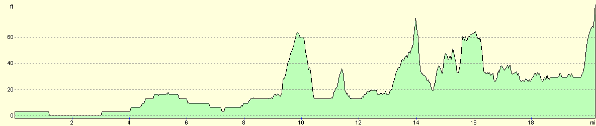
| From | To | Distance (m) | Ascent (ft) | Descent (ft) |
|---|---|---|---|---|
| Shippea Hill Station | Brandon | 11.5 | 108 | 89 |
| Brandon | Stanton Downham | 2.3 | 46 | 23 |
| Stanton Downham | Thetford | 6.4 | 243 | 200 |
This makes a total distance of 20.2 miles, with 397 feet of ascent and 312 feet of descent.
For more information on profiles, ascents and descents, see this page
Transport
There are regular train services from Thetford to Ely. There is a railway station at Shippea Hill, but only one train calls there in each direction every day. You may find it easier to walk from Ely Station to Brandon Station, and then from Brandon to Thetford in two walks. Brandon has much better train services than Shippea Hill.
Disclaimer
Please note that I take no responsibility for anything that may happen when following these directions. If you intend to follow this route, then please use the relevant maps and check the route out before you go out. As always when walking, use common sense and you should be fine.
If you find any information on any of these routes that is inaccurate, or you wish to add anything, then please email me.
All images on this site are © of the author. Any reproduction, retransmissions, or republication of all or part of any document found on this site is expressly prohibited, unless the author has explicitly granted its prior written consent to so reproduce, retransmit, or republish the material. All other rights reserved.
Although this site includes links providing convenient direct access to other Internet sites, I do not endorse, approve, certify or make warranties or representations as to the accuracy of the information on these sites.
And finally, enjoy your walking!
Nearby walks
| # | Title | Walk length (miles) |
|---|---|---|
| 3 | Littleport to Downham Market | 14.0 |
| 169 | Shippea Hill to Littleport via Ely | 15.6 |
| 208 | Thetford to Attleborough | 16.9 |
|
|

|