Walk #1024: Buxton to Macclesfield via Cheeks Hill, Shining Tor and Shutlingsloe
 |
 |
|
General Data
| Date Walked | 24/10/2018 |
| County | Derbyshire, Staffordshire, Cheshire |
| Start Location | Buxton marketplace |
| End Location | Macclesfield station |
| Start time | 07.43 |
| End time | 14.57 |
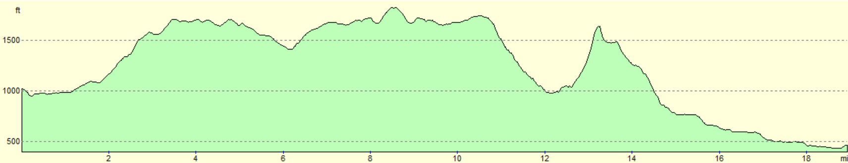
| Distance | 18.8 miles |
| Description | This was a very enjoyable stroll over the western Peak District and into Cheshire, taking in the highest points in Staffordshire and Cheshire on the way. |
| Pack | Today I carried my 30-litre Karrimor rucksack, filled with water, my spare waterproofs, a book and other odds and ends. |
| Condition | I feel absolutely fine after this walk. |
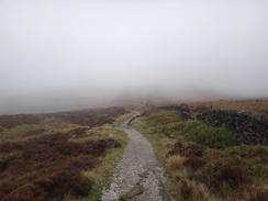
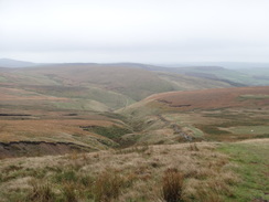
| Weather | Today was very windy, and my westwards walk had to cope with a stiff headwind all day. Although it wasn't warm, it was also not too chilly. Sadly there was also low cloud for much of the day, meaning there were few views to be had from the hills. |
| OS map | Landranger number 119 (Buxton & Matlock, Bakewell & Dove Dale) and Landranger number 118 (Stoke-on-Trent & Macclesfield) |
 |
 |
|
Map of the walk
Maps courtesy of Google Maps. Route for indicative purposes only, and may have been plotted after the walk. Please let me have comments on what you think of this new format. For a detailed table of timings for this walk, please see the table file.
 |
 |
|
Notes
After nearly 20 years of walking, this was my 1024th (or 2 to the power 10th) walk. In that time I have walked the entire coast of Britain, and all bar two of the national trails. I have gained so much from my walking life, and it seemed fitting that this milestone was reached on a walk that took me back to the ground where I did walk #1. I had actually intended to do this walk yesterday, but wimped out due to the weather and went to Nottinghamshire instead. Today’s forecast was not much better with light rain and strong breezes forecast, but this was the last day of this short break available for walking, and so I got into my car and drove in the dark to Buxton.
Light rain was falling as I pulled up in the market place car park and went to buy a ticket. I placed this on the dashboard, but as I was getting the rest of my kit together it blew off. I spent a few minutes trying to find it, eventually locating it under the passenger seat. Hoping it wasn’t a bad omen for the day, I set off.
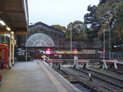
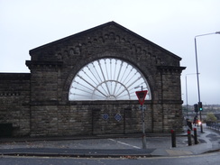
I had three aims for today: to connect previous walks I had done to Buxton and Macclesfield, to walk to Staffordshire’s highest point on Cheeks Hill, and then on to Cheshire’s at Shining Tor. I had done both of these high points before, but felt like doing them again, especially as my first walk on this website had been to Shining Tor. Before any of these, I decided to divert off to Buxton railway station. This is dominated by a large stone gable end wall complete with fanlight; one of two that once marked the twin Midland and LNW railway stations. The current station is sadly just a shadow of its old self, as a model inside the ticket office showed. My map fell out of its case as I crossed the road and I had to dodge traffic to retrieve it, which I took to be another ill omen.
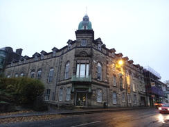
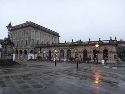
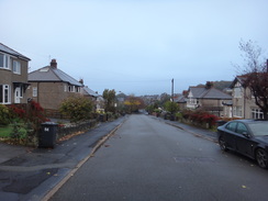
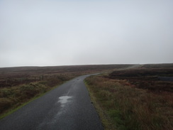
Roads led me southwestwards out of Buxton, slowly climbing past a series of attractive buildings, including the famous opera house. Buxton can sometimes look a little dreary on a wet day like today, but the town seems cleaner and generally more pleasant than it did a couple of decades ago. Children were strolling up and down the road heading for school, and I headed off along a residential road, called the Old Macclesfield Road. The new main road to Macclesfield takes a looping route around the hillsides to reach the tops, whilst this old road takes a more direct, steeper route.
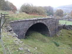
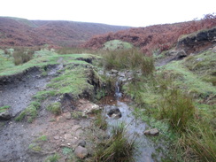
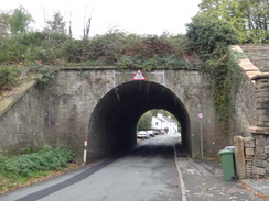
When the tarmac ended I came across the first treat of the day: what looked like a tunnel portal under the track, with a curving embankment leading to it across a small valley. This was a remnant of the old Cromford and High Peak Railway, this portion of which closed in 1892, making it a very early railway closure.
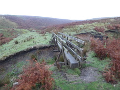
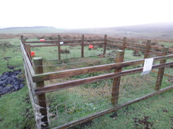
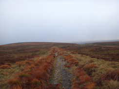
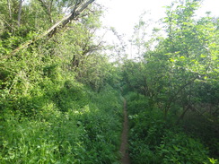
Shortly after this, a path left the old road (barely more than a rough track at this point) and headed off across the moors, crossing a gully on a footbridge before climbing. I have not had to use my compass for years, and I decided to do a little practice on the fairly featureless moors. My navigational skills led me up to a series of little wooden stockades. A sign on one said it was monitored by a coal authority, and is one of several small coal pits dotted around the bleak moor. Several are believed to be hidden, and a sign warned walkers to stick to the paths and report any sudden holes that may appear. It is not an area that would ordinarily be associated with coal mining, and shows what a small-scale affair it used to be, before the old railways and headstocks such as the ones I saw on the last walk started to dominate the industry and landscape.
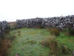
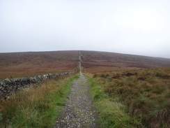
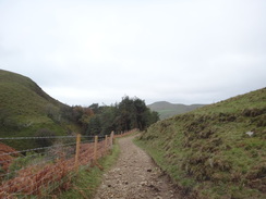
My route took me across the main road and up onto Axe Edge Moor, following a good track. The clouds were low and there were few views, but it felt good to be back on the moors. I made good time to reach a reach a road at Dane Head, which I know to be glorious in sunshine, but today felt bleak in the wind and drizzle. A minor path took me south from the road, and I then diverted up, following a stone wall to reach a small sheepfold at the corner of two walls. This marks Staffordshire’s highest point, and I tried to find the highest point in the fold on which to stand.
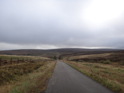
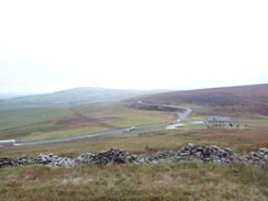
Whereas many county point are literal high points and command grand views, Staffordshire’s is a bit of a disappointment as it is situated on the flank of a hill. It was doubly so in the cloud that surrounded me, so I quickly set off once more along a path that headed back to the road at Dane Head. This took me on to the junction of the Macclesfield and Leek roads, the latter of which is shut for 16 weeks for roadworks. A van guarded the closed road, which I crossed to reach the Macclesfield Road. I could have followed this up to the Cat and Fiddle Inn, but the road is busy and winding. Instead, I took a minor road that descended towards Derbyshire Bridge, before climbing up once more to reach the Cat and Fiddle.
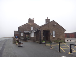
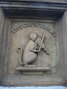
I have many happy memories of this inn, which is the second-highest in England (behind the Tan Hill Inn on the Pennine Way). Unfortunately it has been shut for several years, and appeared securely boarded up as I passed, with the carving of a cat and its fiddle by the door looking rather sorry for itself.
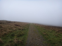
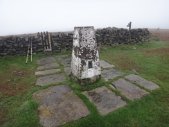
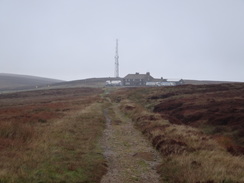
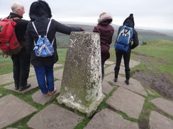
My next target for the day was Cheshire’s highest point at Shining Tor, and I took a trail and then path that led to the summit. The ladder-stile that once provided access to the trig pillar had been replaced with a gate, and I went through to reach the highest point. Grand views are often available from Shining Tor, with the Cheshire Plains and even the massive radio telescope at Jodrell Bank visible; but not today, with the low cloud blocking any such views.
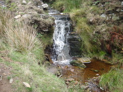
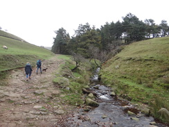
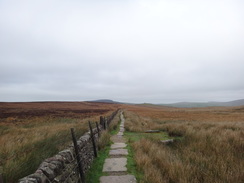
Slightly disappointed, I made my way back to the Cat and Fiddle before following a good track south across the moors. This soon joined a gully on the left, which became a steep-sided valley containing a fast-flowing stream. I took a wrong turn in crossing to the other side of the valley, but soon made my way down to the correct route near what appeared to be broken-down ruins of an old hut. The going was hard but enjoyable, with a slippery jumble of stones underfoot. The gradient slackened and the path became wider as another trail joined, although the stones underfoot were just as slippery.
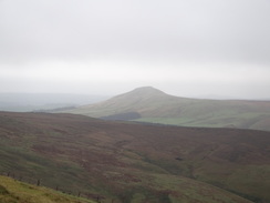
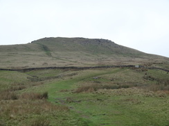
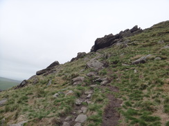
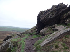
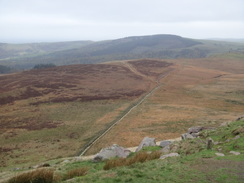
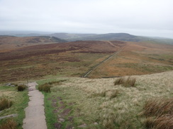
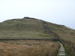
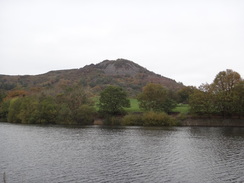
This led down to a farm, and I started a long climb up to the summit of Shutlingsloe, which I had seen through gaps in the clouds from Shining Tor. It is quite a distinctive summit, craggy at one end and smoother at the other, giving rise to its nickname of the ‘Cheshire Matterhorn’. My route rook me up past a large craggy outcrop and on to the trig pillar at the summit, where several other people were standing in the fierce breeze. Not much was to be seen through the cloud, and because of the breeze I decided to make my way down. My climb had been along a tough path, but the descent felt like a motorway, with steps and a stone causey leading down the hill’s northwestern flank. A steady stream of people were making their way up, and this is obviously a very popular route.
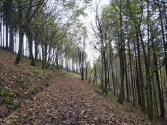
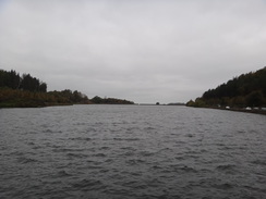
The moorland gave way to the boundary of Macclesfield Forest, the trees giving the area a much darker and gloomier atmosphere to the open moorland. Instead of sticking to the track, I followed a path that plunged downhill through the trees, eventually emerging onto a road by Trentabank Reservoir, which opened in 1929 to provide Macclesfield with a reliable drinking water supply from the headwaters of the River Bollin. Many cars were parked alongside the road, and some must have carried the people who had been climbing up onto Shutlingsloe.
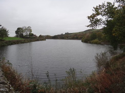
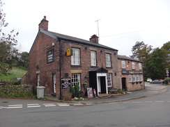
The road took me past Trentabank’s dam, and then on to a second reservoir, Ridgegate. A pub at the end of that reservoir was disgorging a group of merry people, all of whom seemed Cheshire posh, against whom I felt rather dishevelled and unkempt. The road passed a third reservoir, Bottoms, before entering the village of Langley. Here I had a decision to make: I had planned to walk over the summit of Tegg’s Nose and enter Macclesfield from the east, but one look at the summit and the cloud dissuaded me – the hill shall just have to wait for another day. Instead I continued along the road as it headed west towards the southern side of the town.
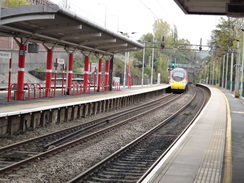
The road passed under the Macclesfield Canal, which I had walked along previously, and this led me to a three-dimensional problem: can I truly claim to have ‘connected’ two walks if one route is directly under the other? Surprisingly there was no way to climb up onto the towpath, so I decided to connect the walks up at Macclesfield railway station instead. The walk north into the town was unremarkable, and I tried to speed up, knowing that a bus was due to leave shortly. I nipped up to the railway station, only to find the bus station, which used to be nearby, had been moved. I strode a short distance through the town to find a spick-and-span bus station, arriving about five minutes before the bus to Buxton was due to leave.
Slightly annoyingly, the clouds parted as the bus climbed past the Cat and Fiddle, allowing the views over the Cheshire Plain that had been denied me from earlier in the day. Despite this it had been an enjoyable day’s walk over both familiar and new terrain.
 |
 |
|
Directions
This walk starts off from Buxton market place at SK05817328. Leave the car park and head onto the main A515 road, and turn left to follow it downhill. When a roundabout is reached at the bottom of the hill, turn right along Station Road and follow it as it swings around to the right to reach Buxton railway station at SK05907374.
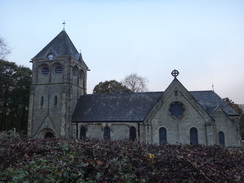
From the station, head back down the road to return to the roundabout, and then head straight on along the A53 St John’s Road. When the road soon curves to the right, continue straight on along the A53. The road passes Buxton Opera House and the Pavillion Gardens on the left, and then crosses the adolescent River Wye on a bridge. The road then starts climbing as it slowly veers to a more southwesterly course; 1.5km after the opera house, it passes Burbage church on the right. Immediately after the church, turn right down Macclesfield Old Road. Initially this falls slightly past houses, before climbing. After 900 metres the surfaced road ends beside a farm at SK03587239.
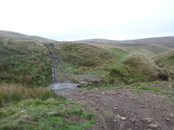
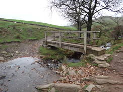
The road becomes a rough, unsurfaced track; follow it as it passes the portal of an old railway bridge below and to the left. Shortly afterwards the track starts to curve to the right, turn left over a stile beside a field gate and follow a rough path that angles away from the track down into a gully, to reach a footbridge over a stream. On the other side continue on to a ford across another stream, and follow the path as it curves left and then gently right to head southwestwards up the other side of the gully, with the A54 road some way away to the left. About 600 metres after the footbridge, wooden stockades guarding old mine workings are reached. Pass between the stockades to reach another stockade beside a track at SK02807167.
Turn left to follow this track south across the moors. Cross a farm bridge over a stream, and when the track curves right towards the A54 road immediately afterwards, veer left to head straight on along a path that soon reaches a stile in a fence. Cross this and continue straight on across rough ground that soon reaches the A54 at SK02897132.
Carefully cross the road, and on the other side cross a stile beside a farm gate to join a track. This soon curves left to head south straight across Axe Edge Moor; as it approaches a road after about 1km it forks; take the left hand branch for a few metres to reach a little gate in a fence that leads onto a road at Dane Head at SK02697032.
Turn left to follow the road eastwards; it crosses a bridge over the River Dane, which is little more than a stream at this point, and after 300 metres and before the crest of the hill, turn right along a path. This doubles back slightly on the road, and is boggy and indistinct in places. It soon veers left to take a more southerly course, and joins a gully away to the left. 650 metres after the road it reaches a gate in a wall; go through the gate and continue on along the rough path down a slight slope. The path soon meets the end of a track. Follow this track for 60 metres, and just before it curves left, turn right up a vague path that climbs northwards. Walls approach on either side; converging at a sheepfold at SK02606988 that marks Staffordshire’s highest point.
Immediately outside the fold, turn left across a stone stile through the wall. On the other side, turn right to follow a vague path northwards. It descends down into a little valley carrying the River Dane, and then climbs up the other side. 530 metres after the sheepfold, the path meets the road near where it was joined earlier. Turn left to follow the road northwestwards across Axe Edge Moor; after 820 metres it ends at a T-junction with the A54. Carefully cross the main road, then turn left for a short distance to reach a road leading off to the right. This in turn soon ends at a junction with the A537 at SK01997098.
Carefully cross the A537, and on the other side head straight on along a minor road. This heads downhill, and after 300 metres curves sharply to the left. It continues to fall, and after another 400 metres ends at a T-junction with a road leading up from Derbyshire Bridge to the right. Turn left up this road, and follow it as it climbs westwards, angling towards the A537. After 1.2km the road ends at a T-junction with the main road. Turn right to follow the A537 northwestwards for a short distance until the Cat and Fiddle is reached at SK00117188.
Carefully head down the A537 away from the inn until you come to a left-hand bend. On the apex of the bend, follow a track that heads straight on northwestwards away from the road. After 250 the track forks; follow the branch that heads off to the right to head north-northeastwards. Go through a clappergate beside a field gate and head on along the track. It passes Stake Farm below to the left, and then reaches a clappergate through a wall. Follow a wall on the left for 170 metres until a clappergate through the wall on the left is reached. Go through this and follow a path that descends down into a little valley before climbing up towards the summit of Shining Tor. After 850 metres the top is reached; go through a gate in the wall ahead to reach Shining Tor trig pillar at SJ99467373. This is Cheshire’s highest point.
From here, return to the Cat and Fiddle. Go through the gate and follow the path that descends southeastwards into a dip, before climbing slightly to reach a clappergate through a wall. On the other side, turn right to follow the wall on the right for 170 metres to reach a clappergate through a wall ahead. Go through this, and on the other side follow a track south, passing Stake Farm below to the right. Go through another clappergate beside a field gate, and follow the track as it curves left, eventually descending slightly to join the A537. Turn left to carefully follow the main road uphill to the Cat and Fiddle Inn at SK00117188.
Carefully cross the main road opposite the pub and go past a vehicle barrier to join a track that heads south across the moors. After 800 metres go through a pedestrian gate in a field gate and continue along the track as it gently curves left for another 300 metres until a junction with a path is reached at SK00107077, signposted for Cumberland Brook and Wildboarclough. Turn right to follow this path as it descends to ford a small stream and then reaches another gate in a gate. Go through this and continue on down the track, as a small valley carrying Cumberland Brook forms on the right. After a while the track curves to the left through a wall on the left at SJ99897037.
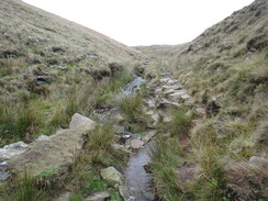
I went wrong here; the next few sentences may have inaccuracies. I have gone with estimated directions as the route I took is almost certainly more dangerous. At the bend, leave the track and continue along a vague path, which soon curves right to descend down into a stream valley. Turn left to follow the stream along, soon crossing it to follow the Cumberland Brook on the right. The path is very rough and stony, and slippery in places as it descends. The path soon fords the stream to follow its western bank, sometimes in the stream, before finally meeting a track at SJ99786997.
Turn right along the track, and immediately cross a stile beside a field gate. The track is rocky and hard on the feet as it slowly descends with the Cumberland Brook off to the left. Cross another stile beside a field gate to reach a footbridge over the brook. Cross this, and continue along the path as it descends past barns on the right to reach a field gate that leads onto a road. Cross the road to head down another road; after a few metres turn left into Clough House’s farmyard at SJ98746977.
Walk to the farmyard’s far left-hand corner, and go through a farm gate into a field. Angle right down the field to reach a footbridge over Clough Brook. Cross the footbridge, and on the other side climb up to reach a road. Cross the road and turn left to cross a stile beside a field gate that leads to a footpath. The footpath follows a wall on the right; when the wall turns right, head straight on for a few metres to a small gate through a wall. On the other side cross a footbridge over a stream and continue along the path as it heads south alongside a wall on the right. The path reaches a gate; go through this and continue on, still following the wall. It passes a barn on the left, and becomes a narrow lane running between walls before passing Banktop farm on the right. The path becomes a track leading from the farm, and soon afterwards a cattle grid is reached at SJ98256907.
Just before the cattle grid, turn right to join a surfaced track that angles northwestwards uphill across a field. As it curves right to go through a wall, turn left to parallel the wall on the right for a few metres to a gap in a stone wall. Continue on up a short, narrow field following a fence on the left. This reaches a footbridge over a small stream and then a clappergate. On the other side of these, heads straight on uphill. At the top of the field, go through a clappergate through a stone wall and continue climbing westwards towards the summit of Shutlingsloe. The path passes below a craggy outcrop of rock on the right, and then turns right to pass the rocks on the right. The path then levels off for the last few metres to the trig pillar at the summit of Shutlingsloe at SJ97636957.
Turn left from the trig pillar and descend some steep stone steps that meet and then follow a wall on the left. This leads to a pedestrian gate; go through this and down some stone steps on the other side to reach a causeyed path that leads northwards. 300 metres after the gate, this reaches a clappergate; go through this and continue along the causey path as it heads northwestwards. After 500 metres the path reaches a clappergate through a stone wall in front of some woodland at SJ97117033.
Go through the clappergate and join a good path that curves left through the trees, before it soon ends at a T-junction with a wider track. Turn left down this track as it slowly falls, and when a fork is reached, take the minor-right hand branch that passes a squeeze stile and starts to fall northwestwards through the trees. At times the descent is steep, but the path is broad. It crosses a track and continues on downhill as a poorer quality path. It approaches Trentabank Reservoir; when a junction with another path is reached turn left, following a fence on the right. This leads to a gate that parallels a road to the right, before a squeeze-stile leads down to the road near a car park at SJ96157117.
Turn right to join a road near Trentabank Reservoir’s dam, and then turn left to follow the road westwards. It curves to the right (ignore a road leading off to the left on the bend), and then passes the eastern end of Ridgegate Reservoir. The road then curves left to pass the northern side of the reservoir, eventually curving left at the far end beside the Leather’s Smithy pub. Follow the road as it passes the pub and heads westwards, passing Bottoms Reservoir on the right and entering the village of Langley, passing the village hall at SJ93937157.
Continue along the road as it heads westwards out of Langley; after 930 metres it reaches the Church House pub in Sutton Lane Ends. The road curves right by the pub to head northwestwards; after another 620 metres the road ends at a T-junction in Gurnett. Turn right to follow another road northwestwards; it soon passes under a bridge carrying the Macclesfield Canal overhead. The road swings right and then left, and crosses a railway line on a bridge before ending after 1.2km at a T-junction with the A523 at SJ92037257.
Turn right to follow the A523 north into Macclesfield. After 450 metres the road forks; do not follow the right-hand branch over a bridge, and instead carefully cross the road to take the left-hand branch that carries the A536 into the town centre. After 180 metres pass the war memorial on the right, and then turn right along Sunderland Street. The road heads north; after 340 metres turn right up Waters Green to reach Macclesfield railway station at SJ91947358.
 |
 |
|
Distances
| From | To | Distance (m) | Ascent (ft) | Descent (ft) |
|---|---|---|---|---|
| Buxton marketplace | Buxton railway station | 0.5 | 33 | 75 |
| Buxton railway station | Cheeks Hill | 4.3 | 971 | 240 |
| Cheeks Hill | Shining Tor | 3.8 | 728 | 597 |
| Shining Tor | Shutingsloe | 4.7 | 991 | 1145 |
| Shutingsloe | MAcclesfield railway station | 5.5 | 105 | 1362 |
This makes a total distance of 18.8 miles, with 2828 feet of ascent and 3419 feet of descent.
For more information on profiles, ascents and descents, see this page
Transport
Centrebus run regular bus services on the High Peak 58 route between Macclesfield and Buxton. See their timetable for more information.
 |
 |
|
 |
 |
|
 |
 |
|
 |
 |
|
 |
 |
|
 |
 |
|
 |
 |
|
 |
 |
|
 |
 |
|
 |
 |
|
 |
 |
|
 |
 |
|
 |
 |
|
 |
 |
|
 |
 |
|
 |
 |
|
 |
 |
|
 |
 |
|
 |
 |
|
 |
 |
|
Disclaimer
Please note that I take no responsibility for anything that may happen when following these directions. If you intend to follow this route, then please use the relevant maps and check the route out before you go out. As always when walking, use common sense and you should be fine.
If you find any information on any of these routes that is inaccurate, or you wish to add anything, then please email me.
All images on this site are © of the author. Any reproduction, retransmissions, or republication of all or part of any document found on this site is expressly prohibited, unless the author has explicitly granted its prior written consent to so reproduce, retransmit, or republish the material. All other rights reserved.
Although this site includes links providing convenient direct access to other Internet sites, I do not endorse, approve, certify or make warranties or representations as to the accuracy of the information on these sites.
And finally, enjoy your walking!
Nearby walks
| # | Title | Walk length (miles) |
|---|---|---|
| 1 | Shining Tor and Cat's Tor from the Cat and Fiddle pub | 7.2 |
| 22 | The Limestone Way from Matlock to Pomeroy | 16.9 |
| 23 | The Limestone Way from Pomeroy to Castleton | 14.0 |
|
|

|